

<< Our Photo Pages >> Caer Kief - Ancient Village or Settlement in England in Cornwall
Submitted by Bladup on Thursday, 13 April 2017 Page Views: 2415
Multi-periodSite Name: Caer KiefCountry: England
NOTE: This site is 0.299 km away from the location you searched for.
County: Cornwall Type: Ancient Village or Settlement
Map Ref: SW782525
Latitude: 50.330579N Longitude: 5.117831W
Condition:
| 5 | Perfect |
| 4 | Almost Perfect |
| 3 | Reasonable but with some damage |
| 2 | Ruined but still recognisable as an ancient site |
| 1 | Pretty much destroyed, possibly visible as crop marks |
| 0 | No data. |
| -1 | Completely destroyed |
| 5 | Superb |
| 4 | Good |
| 3 | Ordinary |
| 2 | Not Good |
| 1 | Awful |
| 0 | No data. |
| 5 | Can be driven to, probably with disabled access |
| 4 | Short walk on a footpath |
| 3 | Requiring a bit more of a walk |
| 2 | A long walk |
| 1 | In the middle of nowhere, a nightmare to find |
| 0 | No data. |
| 5 | co-ordinates taken by GPS or official recorded co-ordinates |
| 4 | co-ordinates scaled from a detailed map |
| 3 | co-ordinates scaled from a bad map |
| 2 | co-ordinates of the nearest village |
| 1 | co-ordinates of the nearest town |
| 0 | no data |
Be the first person to rate this site - see the 'Contribute!' box in the right hand menu.
Internal Links:
External Links:
")
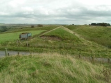
Caer Kief is a Sub-rectangular earthwork enclosure of the iron age with an entrance on the eastern side. Most recently interpreted as a prehistoric round. It measures 120 metres by 125 metres enclosed by a bank 1.2 metres high and 4.2 metres wide fronted by a ditch with an average width of 4 metres.
You may be viewing yesterday's version of this page. To see the most up to date information please register for a free account.
")
")
")
")
")
")
")
")
")
Do not use the above information on other web sites or publications without permission of the contributor.
Click here to see more info for this site
Nearby sites
Key: Red: member's photo, Blue: 3rd party photo, Yellow: other image, Green: no photo - please go there and take one, Grey: site destroyed
Download sites to:
KML (Google Earth)
GPX (GPS waypoints)
CSV (Garmin/Navman)
CSV (Excel)
To unlock full downloads you need to sign up as a Contributory Member. Otherwise downloads are limited to 50 sites.
Turn off the page maps and other distractions
Nearby sites listing. In the following links * = Image available
582m WSW 237° Caer Dane* Ancient Village or Settlement (SW777522)
2.0km N 349° Piran's Round* Ancient Village or Settlement (SW779545)
3.1km NNE 20° Twelve barrows* Barrow Cemetery (SW794554)
4.1km NNW 344° St Piran's Cross* Ancient Cross (SW7722156450)
4.1km NNW 338° St. Piran's Lost Oratory* Early Christian Sculptured Stone (SW768564)
4.7km SSW 202° Kenwyn Four Burrows* Barrow Cemetery (SW762482)
5.1km NNE 14° Cubert Round* Ancient Village or Settlement (SW796574)
5.3km N 2° Cubert.* Early Christian Sculptured Stone (SW786578)
6.0km NNW 335° Ligger Point Barrows* Barrow Cemetery (SW759580)
6.0km SE 126° Bishops Wood Fort* Hillfort (SW82914873)
6.3km S 177° Bosvisack Round* Hillfort (SW78254624)
6.4km WSW 252° St Agnes Cornish Cross* Ancient Cross (SW720508)
6.4km N 350° Trevornick Farm* Holy Well or Sacred Spring (SW7733958890)
6.5km ENE 75° Warren's Barrow* Barrow Cemetery (SW846539)
6.6km SSE 167° Penventinnie Round* Ancient Village or Settlement (SW79374603)
6.9km N 356° Cubert Common Tumulus* Round Barrow(s) (SW78055943)
7.0km NNW 338° Penhale Point Cliff Castle* Promontory Fort / Cliff Castle (SW758591)
7.3km SW 218° Two Burrows Round Barrow* Round Barrow(s) (SW735469)
7.4km WSW 244° Bolster Bank* Misc. Earthwork (SW714496)
7.5km WSW 251° St Agnes Beacon* Barrow Cemetery (SW710503)
7.6km SSE 149° Kenwyn* Holy Well or Sacred Spring (SW819458)
7.7km NNW 346° Holywell Bay* Holy Well or Sacred Spring (SW76636002)
7.9km N 3° Crantock* Holy Well or Sacred Spring (SW789604)
8.0km S 191° Saveock Water Archaeology Modern Stone Circle etc (SW76324476)
8.2km N 2° St Ambrusca's Well* Holy Well or Sacred Spring (SW789607)
View more nearby sites and additional images


 We would like to know more about this location. Please feel free to add a brief description and any relevant information in your own language.
 Wir möchten mehr über diese Stätte erfahren. Bitte zögern Sie nicht, eine kurze Beschreibung und relevante Informationen in Deutsch hinzuzufügen.
 Nous aimerions en savoir encore un peu sur les lieux. S'il vous plaît n'hesitez pas à ajouter une courte description et tous les renseignements pertinents dans votre propre langue.
 Quisieramos informarnos un poco más de las lugares. No dude en añadir una breve descripción y otros datos relevantes en su propio idioma.