 with our Megalithic Portal iPhone app")


<< Our Photo Pages >> West Highland Museum - Museum in Scotland in Highlands
Submitted by caradoc68 on Thursday, 05 July 2012 Page Views: 4901
MuseumsSite Name: West Highland MuseumCountry: Scotland
NOTE: This site is 23.301 km away from the location you searched for.
County: Highlands Type: Museum
Nearest Town: Fort William
Map Ref: NN102738
Latitude: 56.816845N Longitude: 5.11127W
Condition:
| 5 | Perfect |
| 4 | Almost Perfect |
| 3 | Reasonable but with some damage |
| 2 | Ruined but still recognisable as an ancient site |
| 1 | Pretty much destroyed, possibly visible as crop marks |
| 0 | No data. |
| -1 | Completely destroyed |
| 5 | Superb |
| 4 | Good |
| 3 | Ordinary |
| 2 | Not Good |
| 1 | Awful |
| 0 | No data. |
| 5 | Can be driven to, probably with disabled access |
| 4 | Short walk on a footpath |
| 3 | Requiring a bit more of a walk |
| 2 | A long walk |
| 1 | In the middle of nowhere, a nightmare to find |
| 0 | No data. |
| 5 | co-ordinates taken by GPS or official recorded co-ordinates |
| 4 | co-ordinates scaled from a detailed map |
| 3 | co-ordinates scaled from a bad map |
| 2 | co-ordinates of the nearest village |
| 1 | co-ordinates of the nearest town |
| 0 | no data |
Internal Links:
External Links:
")
Polished stone axes were the oldest archaeological objects found in the West Highland region, and date from the Neolithic period (around 2000BCE). The use of metal axes became widespread soon afterwards, and the museum has examples of these, as well as the heads of the earlier stone axes.
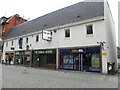
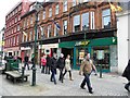
The West Highland Museum is situated just off the main pedestrianised High Street in Fort William at Cameron Square, a ten-minute walk from both the bus station and the rail station. Street parking in Fort William is very limited but the town’s main public car parks are all within a 5-10 minute walk from the Museum.
West Highland Museum
Cameron Square
Fort William
Scotland
PH33 6AJ
Mar 10:00 - 16:00 Mon - Sat
Apr - Oct 10:00 - 17:00 Mon - Sat
Nov - Dec 10:00 - 16:00 Mon - Sat
Jan - Feb Closed
Admission is FREE
Official Web Site: www.westhighlandmuseum.org.uk
You may be viewing yesterday's version of this page. To see the most up to date information please register for a free account.
")
")
Do not use the above information on other web sites or publications without permission of the contributor.
Nearby Images from Geograph Britain and Ireland:

©2009(licence)
©2011(licence)
©2011(licence)

©2011(licence)

©2011(licence)
The above images may not be of the site on this page, they are loaded from Geograph.
Please Submit an Image of this site or go out and take one for us!
Click here to see more info for this site
Nearby sites
Key: Red: member's photo, Blue: 3rd party photo, Yellow: other image, Green: no photo - please go there and take one, Grey: site destroyed
Download sites to:
KML (Google Earth)
GPX (GPS waypoints)
CSV (Garmin/Navman)
CSV (Excel)
To unlock full downloads you need to sign up as a Contributory Member. Otherwise downloads are limited to 50 sites.
Turn off the page maps and other distractions
Nearby sites listing. In the following links * = Image available
2.0km E 96° Samuel's Stone* Natural Stone / Erratic / Other Natural Feature (NN122735)
3.0km SE 124° Dun Dige* Round Barrow(s) (NN126720)
4.5km SE 143° Dun Deardail* Vitrified Fort (NN127701)
14.6km SSW 195° Bishop's Rock* Rock Art (NN058599)
14.6km SSW 195° North Ballachulish* Rock Art (NN057599)
14.6km SSW 209° Clach-a-charra* Standing Stone (Menhir) (NN02566134)
14.6km SSW 198° Rubha Mor* Cairn (NN05146007)
15.2km SSW 198° Ballachulish House* Chambered Cairn (NN04885951)
15.6km ENE 60° Killichonate Well* Holy Well or Sacred Spring (NN241810)
22.1km ENE 58° Glen Roy Chalice Stone* Rock Art (NN295847)
22.4km SSW 208° Achara Standing Stone* Standing Stone (Menhir) (NM98665455)
26.5km SSE 168° Invercharnan (Glen Etive) Cairn (NN14394761)
31.1km WSW 244° Clach a' Phoanais (Strontian)* Standing Stone (Menhir) (NM8158061357)
31.2km SSW 200° St Cairrell's Well* Holy Well or Sacred Spring (NM980450)
31.7km SSW 211° Cairnbane (Portnacroish) Chambered Cairn (NM926473)
32.4km NE 36° Well of the Heads* Holy Well or Sacred Spring (NN3047399140)
33.2km NNE 27° Cill Donnain* Early Christian Sculptured Stone (NH26580276)
34.5km SSW 201° Barcaldine* Standing Stones (NM96374213)
35.8km S 186° Muirheadstone* Natural Stone / Erratic / Other Natural Feature (NN050383)
36.5km SSW 203° Achacha standing stone* Standing Stone (Menhir) (NM94444075)
36.6km SSW 203° Achacha Cairn* Cairn (NM94364076)
37.2km SSW 210° Eriska Crannog* Crannog (NM90114239)
38.1km SW 216° Cnoc Aingil Cairn (NM86384397)
38.3km SSW 210° Balure Cairns* Cairn (NM89604145)
38.4km SSW 209° Achnamoine 2* Cairn (NM89974104)
View more nearby sites and additional images


 We would like to know more about this location. Please feel free to add a brief description and any relevant information in your own language.
 Wir möchten mehr über diese Stätte erfahren. Bitte zögern Sie nicht, eine kurze Beschreibung und relevante Informationen in Deutsch hinzuzufügen.
 Nous aimerions en savoir encore un peu sur les lieux. S'il vous plaît n'hesitez pas à ajouter une courte description et tous les renseignements pertinents dans votre propre langue.
 Quisieramos informarnos un poco más de las lugares. No dude en añadir una breve descripción y otros datos relevantes en su propio idioma.