


<< Our Photo Pages >> St Mary's Well (Rothsay) - Holy Well or Sacred Spring in Scotland in Isle of Bute
Submitted by Anne T on Sunday, 08 October 2017 Page Views: 2435
Springs and Holy WellsSite Name: St Mary''s Well (Rothsay)Country: Scotland
NOTE: This site is 0.667 km away from the location you searched for.
County: Isle of Bute Type: Holy Well or Sacred Spring
Nearest Town: Rothsay
Map Ref: NS0866763750
Latitude: 55.828949N Longitude: 5.056355W
Condition:
| 5 | Perfect |
| 4 | Almost Perfect |
| 3 | Reasonable but with some damage |
| 2 | Ruined but still recognisable as an ancient site |
| 1 | Pretty much destroyed, possibly visible as crop marks |
| 0 | No data. |
| -1 | Completely destroyed |
| 5 | Superb |
| 4 | Good |
| 3 | Ordinary |
| 2 | Not Good |
| 1 | Awful |
| 0 | No data. |
| 5 | Can be driven to, probably with disabled access |
| 4 | Short walk on a footpath |
| 3 | Requiring a bit more of a walk |
| 2 | A long walk |
| 1 | In the middle of nowhere, a nightmare to find |
| 0 | No data. |
| 5 | co-ordinates taken by GPS or official recorded co-ordinates |
| 4 | co-ordinates scaled from a detailed map |
| 3 | co-ordinates scaled from a bad map |
| 2 | co-ordinates of the nearest village |
| 1 | co-ordinates of the nearest town |
| 0 | no data |
Be the first person to rate this site - see the 'Contribute!' box in the right hand menu.
Internal Links:
External Links:
I have visited· I would like to visit
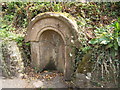
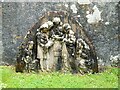
Anne T visited on 25th Sep 2017 - their rating: Cond: 2 Amb: 3 Access: 5 St. Mary's Well, Rothsay: Almost immediately across the road from St Mary's Chapel, set into a dry stone wall and very sadly neglected. There is no outlet but the remains of a metal tethering ring for a cup or ladle is still embedded in the arch. Worth a walk across from the chapel to take a look.
 (PID:171990)")
Canmore describes this well head as being 19th century, although the source of the water may be much older.
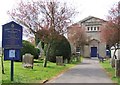
Virtually opposite St. Mary's Chapel (where two ancient crosses were located, but which have now been moved - one to the Castle, the other to the Museum), the 1954 entry Canmore ID 40384 tells us the "well-housing is of sandstone blocks in the shape of a solid arch approx 4ft high. A metal insert contains a turn-knob and water-outlet. The feature is in sound condition but dry."
A more recent entry from 2010 updates this, saying: "This well stands on the E side of the B881 public road 65m NE of St Mary’s Chapel. The top of the shaft is formed of dressed sandstone blocks into which a modern drain cover has been set and the wellhead comprises a tri-partite Romanesque arched recess set into a later rubble boundary wall. This arch is inscribed ‘St Mary’s Well’ and a metal tethering ring, probably for a cup or ladle, is attached. The turn-knob and water-outlet (tap) noted in 1954 have been removed."
You may be viewing yesterday's version of this page. To see the most up to date information please register for a free account.
 (PID:171992)")
 (PID:171991)")
 (PID:171989)")
Do not use the above information on other web sites or publications without permission of the contributor.
Nearby Images from Geograph Britain and Ireland:
©2009(licence)
©2009(licence)
©2022(licence)
©2009(licence)
©2017(licence)
The above images may not be of the site on this page, they are loaded from Geograph.
Please Submit an Image of this site or go out and take one for us!
Click here to see more info for this site
Nearby sites
Key: Red: member's photo, Blue: 3rd party photo, Yellow: other image, Green: no photo - please go there and take one, Grey: site destroyed
Download sites to:
KML (Google Earth)
GPX (GPS waypoints)
CSV (Garmin/Navman)
CSV (Excel)
To unlock full downloads you need to sign up as a Contributory Member. Otherwise downloads are limited to 50 sites.
Turn off the page maps and other distractions
Nearby sites listing. In the following links * = Image available
258m SSW 192° Townhead Neolithic Settlement Ancient Village or Settlement (NS086635)
1.2km W 263° Craigberoch* Standing Stone (Menhir) (NS0745263652)
2.8km SW 223° Loch Dhu Crannog* Crannog (NS06646176)
3.3km NW 311° Dun Burgidale* Stone Fort or Dun (NS0627766051)
3.4km SE 145° Mountstuart* Cist (NS1048360922)
4.0km SW 215° Bicker's Houses* Chambered Cairn (NS062606)
4.5km NW 313° Acholter* Standing Stone (Menhir) (NS0546466961)
4.6km SSW 202° Ambrisbeg Hill Cairn* Cairn (NS0677459579)
5.1km NW 310° Colmac Bridge* Standing Stone (Menhir) (NS0491367160)
5.1km SSW 207° Loch Quien Crannog* Crannog (NS06185929)
5.1km W 272° Castle Cree* Hillfort (NS0356464133)
5.2km WNW 293° St Colmac's A Stone Circle (NS040660)
5.2km WNW 303° St Colmac Cottages Stone Circle* Stone Circle (NS044668)
5.4km WSW 245° St. Ninian's Bay* Standing Stones (NS037617)
5.4km NW 308° St Colmac's Cross Standing Stone (Menhir) (NS0452167263)
5.7km SSW 206° Scalpsie Barrow* Round Cairn (NS05955873)
6.0km SSW 209° Scalpsie Dun* Stone Fort or Dun (NS05485866)
7.1km WSW 247° Inchmarnock Cists Cist (NS0199361233)
8.1km S 174° Blackpark* Stone Circle (NS0916455666)
8.4km S 179° Stravanan Bay* Stone Row / Alignment (NS0846555361)
9.1km WNW 297° Glecknabae* Chambered Cairn (NS0074568263)
9.5km W 271° Ardlamont Point* Rock Art (NR99146439)
9.7km WNW 302° Carnbaan* Chambered Cairn (NS0063269316)
10.0km NE 36° Creag Bhreac Cairn* Cairn (NS1495571532)
10.3km S 173° St Blane's Well* Ancient Cross (NS0944253442)
View more nearby sites and additional images


 We would like to know more about this location. Please feel free to add a brief description and any relevant information in your own language.
 Wir möchten mehr über diese Stätte erfahren. Bitte zögern Sie nicht, eine kurze Beschreibung und relevante Informationen in Deutsch hinzuzufügen.
 Nous aimerions en savoir encore un peu sur les lieux. S'il vous plaît n'hesitez pas à ajouter une courte description et tous les renseignements pertinents dans votre propre langue.
 Quisieramos informarnos un poco más de las lugares. No dude en añadir una breve descripción y otros datos relevantes en su propio idioma.