

<< Our Photo Pages >> Allt Sgiathaig - Chambered Cairn in Scotland in Sutherland
Submitted by Andy B on Wednesday, 01 September 2010 Page Views: 3516
Neolithic and Bronze AgeSite Name: Allt SgiathaigCountry: Scotland
NOTE: This site is 2.325 km away from the location you searched for.
County: Sutherland Type: Chambered Cairn
Map Ref: NC23412552
Latitude: 58.183067N Longitude: 5.005075W
Condition:
| 5 | Perfect |
| 4 | Almost Perfect |
| 3 | Reasonable but with some damage |
| 2 | Ruined but still recognisable as an ancient site |
| 1 | Pretty much destroyed, possibly visible as crop marks |
| 0 | No data. |
| -1 | Completely destroyed |
| 5 | Superb |
| 4 | Good |
| 3 | Ordinary |
| 2 | Not Good |
| 1 | Awful |
| 0 | No data. |
| 5 | Can be driven to, probably with disabled access |
| 4 | Short walk on a footpath |
| 3 | Requiring a bit more of a walk |
| 2 | A long walk |
| 1 | In the middle of nowhere, a nightmare to find |
| 0 | No data. |
| 5 | co-ordinates taken by GPS or official recorded co-ordinates |
| 4 | co-ordinates scaled from a detailed map |
| 3 | co-ordinates scaled from a bad map |
| 2 | co-ordinates of the nearest village |
| 1 | co-ordinates of the nearest town |
| 0 | no data |
Internal Links:
External Links:
I have visited· I would like to visit
SumDoood would like to visit
")
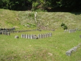
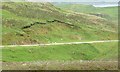
The cairn is placed on a knoll at about 500' OD on a steep moorland hillside. It has a diameter of 35' and a height of c. 4'. Two slabs on its N edge have the appearance of being kerb stones, while the cairn seems to have spread to the NE and SW beyond its original limits. The NW side has been severely robbed and all traces of the passage, which apparently entered the chamber from this side, have probably been destroyed.
The chamber is partly ruined and filled with large slabs and debris. Two upright slabs on the W side, one slightly displaced forwards, are exposed to a height of nearly 3' and probably represent the portal stones between the passage and chamber. Two verticial but lower stones and two stretches of walling on the E side indicate a chamber c. 7' long by c. 5' wide.
Road improvements have caused the ground to be cut away to the very edge of the cairn on the NW side.
More: Scotland's Places
You may be viewing yesterday's version of this page. To see the most up to date information please register for a free account.
")
")
")
")
Do not use the above information on other web sites or publications without permission of the contributor.
Nearby Images from Geograph Britain and Ireland:
©2013(licence)
©2018(licence)
©2006(licence)
©2006(licence)
©2022(licence)
The above images may not be of the site on this page, they are loaded from Geograph.
Please Submit an Image of this site or go out and take one for us!
Click here to see more info for this site
Nearby sites
Key: Red: member's photo, Blue: 3rd party photo, Yellow: other image, Green: no photo - please go there and take one, Grey: site destroyed
Download sites to:
KML (Google Earth)
GPX (GPS waypoints)
CSV (Garmin/Navman)
CSV (Excel)
To unlock full downloads you need to sign up as a Contributory Member. Otherwise downloads are limited to 50 sites.
Turn off the page maps and other distractions
Nearby sites listing. In the following links * = Image available
1.9km SSE 156° Ardvreck* Chambered Cairn (NC24142371)
4.6km SE 142° Carrachan Dubh Chambered Cairn (NC26102176)
7.4km W 264° Loch Assynt Crannog (NC1603225018)
8.7km NNW 346° Kylestrome Broch* Broch or Nuraghe (NC217341)
9.2km SSE 156° Allt nan Uamh Bone Caves* Cave or Rock Shelter (NC268170)
10.1km NW 317° An Dun (Loch Ardbhair)* Broch or Nuraghe (NC16893324)
11.5km S 170° Ledbeg River* Chambered Cairn (NC24891411)
12.4km S 177° Cam Loch B Chambered Cairn (NC23431314)
12.4km S 177° Cam Loch A Cairn (NC23501312)
13.4km S 176° Ledmore* Chambered Cairn (NC23821215)
13.5km S 182° Glacbain* Cairn (NC2231112011)
14.3km SSE 168° Loch Borralan Crannog* Crannog (NC25741138)
14.6km SSE 167° Loch Borralan West* Chambered Cairn (NC2603811142)
14.6km SSE 166° Loch Borralan East* Chambered Cairn (NC26241118)
14.8km SSE 165° Altnacealgach* Chambered Cairn (NC2652811033)
18.3km SSE 157° Cnoc Chaornaidh North West* Chambered Cairn (NC299084)
18.6km SSE 156° Cnoc Chaornaidh Central* Cairn (NC30170818)
18.6km NNW 336° Cnoc An Daimh* Chambered Cairn (NC1667342937)
18.9km SSE 156° Cnoc Chaornaidh South-east* Chambered Cairn (NC30320793)
19.5km WSW 237° Inverpolly Stone Fort or Dun (NC06611551)
19.8km W 274° Clachtoll Stone Circle* Stone Circle (NC037278)
19.8km W 274° Clachtoll Broch* Broch or Nuraghe (NC03652785)
20.5km WNW 282° Loch Na Claise Crannog (NC03543082)
21.3km N 353° Badnabay* Chambered Cairn (NC218468)
22.7km SE 126° Dail Langwell Broch or Nuraghe (NC41161121)
View more nearby sites and additional images


 We would like to know more about this location. Please feel free to add a brief description and any relevant information in your own language.
 Wir möchten mehr über diese Stätte erfahren. Bitte zögern Sie nicht, eine kurze Beschreibung und relevante Informationen in Deutsch hinzuzufügen.
 Nous aimerions en savoir encore un peu sur les lieux. S'il vous plaît n'hesitez pas à ajouter une courte description et tous les renseignements pertinents dans votre propre langue.
 Quisieramos informarnos un poco más de las lugares. No dude en añadir una breve descripción y otros datos relevantes en su propio idioma.