


<< Our Photo Pages >> Grennan Point - Promontory Fort / Cliff Castle in Scotland in Dumfries and Galloway
Submitted by SolarMegalith on Friday, 30 September 2016 Page Views: 1658
Iron Age and Later PrehistorySite Name: Grennan PointCountry: Scotland
NOTE: This site is 0.604 km away from the location you searched for.
County: Dumfries and Galloway Type: Promontory Fort / Cliff Castle
Map Ref: NX07604377
Latitude: 54.751928N Longitude: 4.9912W
Condition:
| 5 | Perfect |
| 4 | Almost Perfect |
| 3 | Reasonable but with some damage |
| 2 | Ruined but still recognisable as an ancient site |
| 1 | Pretty much destroyed, possibly visible as crop marks |
| 0 | No data. |
| -1 | Completely destroyed |
| 5 | Superb |
| 4 | Good |
| 3 | Ordinary |
| 2 | Not Good |
| 1 | Awful |
| 0 | No data. |
| 5 | Can be driven to, probably with disabled access |
| 4 | Short walk on a footpath |
| 3 | Requiring a bit more of a walk |
| 2 | A long walk |
| 1 | In the middle of nowhere, a nightmare to find |
| 0 | No data. |
| 5 | co-ordinates taken by GPS or official recorded co-ordinates |
| 4 | co-ordinates scaled from a detailed map |
| 3 | co-ordinates scaled from a bad map |
| 2 | co-ordinates of the nearest village |
| 1 | co-ordinates of the nearest town |
| 0 | no data |
Internal Links:
External Links:
I have visited· I would like to visit
SolarMegalith visited on 21st Sep 2016 - their rating: Cond: 2 Amb: 4 Access: 4
")
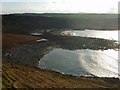
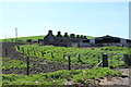
Remains of an Iron Age promontory fort overlooking Drumbreddan Bay to the south. Trace of a ditch protecting the fort from inland are still distinguishable, but no remains of a rampart can be distinguished.
For more information see Canmore ID 60510.
You may be viewing yesterday's version of this page. To see the most up to date information please register for a free account.
")
")
")
Do not use the above information on other web sites or publications without permission of the contributor.
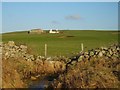
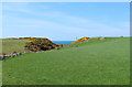
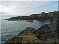
Nearby Images from Geograph Britain and Ireland:
©2008(licence)
©2008(licence)
©2013(licence)
©2015(licence)
©2013(licence)
The above images may not be of the site on this page, they are loaded from Geograph.
Please Submit an Image of this site or go out and take one for us!
Click here to see more info for this site
Nearby sites
Key: Red: member's photo, Blue: 3rd party photo, Yellow: other image, Green: no photo - please go there and take one, Grey: site destroyed
Download sites to:
KML (Google Earth)
GPX (GPS waypoints)
CSV (Garmin/Navman)
CSV (Excel)
To unlock full downloads you need to sign up as a Contributory Member. Otherwise downloads are limited to 50 sites.
Turn off the page maps and other distractions
Nearby sites listing. In the following links * = Image available
1.3km NW 313° Doon Castle (Broch)* Broch or Nuraghe (NX0670244683)
2.2km ESE 113° St Mary's Well (Logan) Holy Well or Sacred Spring (NX096428)
2.6km E 93° Logan House* Standing Stone (Menhir) (NX10224354)
3.4km NNW 348° Craigencroy* Cairn (NX07064711)
4.6km N 3° Kirkmadrine Church Stones* Early Christian Sculptured Stone (NX0801448389)
4.7km ESE 111° Chipperdingan Well (New England Bay) Holy Well or Sacred Spring (NX11904190)
4.8km NNW 345° Mid Float W* Natural Stone / Erratic / Other Natural Feature (NX06584844)
4.8km NNW 348° Mid Float E* Standing Stone (Menhir) (NX06804851)
4.9km N 10° Cairnweil standing stone* Standing Stone (Menhir) (NX0863748556)
5.3km ESE 116° Terally Bay* Standing Stone (Menhir) (NX12284127)
5.3km NNW 347° Whirlpool* Standing Stone (Menhir) (NX06624898)
5.6km SE 138° Inchmulloch Hill* Standing Stone (Menhir) (NX1113739421)
5.8km SE 128° St Bride's Well (Kirkmaiden Parish) Holy Well or Sacred Spring (NX1240)
7.7km SE 136° Kilstay* Standing Stone (Menhir) (NX1273738072)
8.1km SSE 158° Cairn Fell* Cairn (NX10333612)
8.4km SE 143° Core Hill* Hillfort (NX12433686)
9.4km SE 140° Lady Well (Low Drummore) Holy Well or Sacred Spring (NX13303626)
9.8km S 170° Crammag Head* Promontory Fort / Cliff Castle (NX08913404)
9.9km NNW 328° Knockinaam Standing Stone* Standing Stone (Menhir) (NX02695242)
10.5km SSE 158° Muntloch Well (Drummore) Holy Well or Sacred Spring (NX11153384)
10.7km N 350° St Catherine's Well (Eldrickhill) Holy Well or Sacred Spring (NX06125442)
12.7km NW 322° St Patrick's Well (Portpatrick) Holy Well or Sacred Spring (NX00105411)
12.9km NNW 343° Cairn Pat* Hillfort (NX04425632)
13.4km SSE 153° Kibbertie Kite Well (West Cairngaan) Holy Well or Sacred Spring (NX13193160)
13.8km SSE 153° West Cairngaan stone* Standing Stone (Menhir) (NX13393126)
View more nearby sites and additional images


 We would like to know more about this location. Please feel free to add a brief description and any relevant information in your own language.
 Wir möchten mehr über diese Stätte erfahren. Bitte zögern Sie nicht, eine kurze Beschreibung und relevante Informationen in Deutsch hinzuzufügen.
 Nous aimerions en savoir encore un peu sur les lieux. S'il vous plaît n'hesitez pas à ajouter une courte description et tous les renseignements pertinents dans votre propre langue.
 Quisieramos informarnos un poco más de las lugares. No dude en añadir una breve descripción y otros datos relevantes en su propio idioma.