

<< Our Photo Pages >> Glaid Stone - Natural Stone / Erratic / Other Natural Feature in Scotland in North Ayrshire
Submitted by markj99 on Monday, 26 October 2020 Page Views: 1026
Natural PlacesSite Name: Glaid StoneCountry: Scotland County: North Ayrshire Type: Natural Stone / Erratic / Other Natural Feature
Nearest Town: Millport
Map Ref: NS16765700
Latitude: 55.771520N Longitude: 4.922792W
Condition:
| 5 | Perfect |
| 4 | Almost Perfect |
| 3 | Reasonable but with some damage |
| 2 | Ruined but still recognisable as an ancient site |
| 1 | Pretty much destroyed, possibly visible as crop marks |
| 0 | No data. |
| -1 | Completely destroyed |
| 5 | Superb |
| 4 | Good |
| 3 | Ordinary |
| 2 | Not Good |
| 1 | Awful |
| 0 | No data. |
| 5 | Can be driven to, probably with disabled access |
| 4 | Short walk on a footpath |
| 3 | Requiring a bit more of a walk |
| 2 | A long walk |
| 1 | In the middle of nowhere, a nightmare to find |
| 0 | No data. |
| 5 | co-ordinates taken by GPS or official recorded co-ordinates |
| 4 | co-ordinates scaled from a detailed map |
| 3 | co-ordinates scaled from a bad map |
| 2 | co-ordinates of the nearest village |
| 1 | co-ordinates of the nearest town |
| 0 | no data |
Internal Links:
External Links:
")
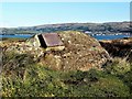
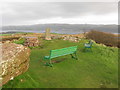
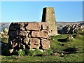
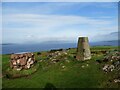
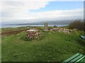
The Glaid Stone is a natural erratic stone deposited on top of Barbay Hill, 2 km N of Millport. It is c. 12 feet long with a 4x4 feet cross section. The Glaid Stone is quite impressive however the panorama from the summit is more impressive.
Barbay Hill is the highest point on Great Cumbrae at 127 m above sea level.
A minor road from Millport winds past the Glaid Stone completing a 7 km circuit back to Millport.
You may be viewing yesterday's version of this page. To see the most up to date information please register for a free account.
")
")
Do not use the above information on other web sites or publications without permission of the contributor.
Nearby Images from Geograph Britain and Ireland:
©2017(licence)
©2017(licence)
©2017(licence)
©2021(licence)
©2023(licence)
The above images may not be of the site on this page, they are loaded from Geograph.
Please Submit an Image of this site or go out and take one for us!
Click here to see more info for this site
Nearby sites
Key: Red: member's photo, Blue: 3rd party photo, Yellow: other image, Green: no photo - please go there and take one, Grey: site destroyed
Download sites to:
KML (Google Earth)
GPX (GPS waypoints)
CSV (Garmin/Navman)
CSV (Excel)
To unlock full downloads you need to sign up as a Contributory Member. Otherwise downloads are limited to 50 sites.
Turn off the page maps and other distractions
Nearby sites listing. In the following links * = Image available
1.0km ESE 122° Gouklan Stone Standing Stone (Menhir) (NS17615641)
2.5km NNE 32° Tomont End Cairns, Isle of Great Cumbrae* Cairn (NS182591)
4.0km ENE 64° Broomfields Menhir Standing Stone (Menhir) (NS20475864)
4.5km ENE 67° Haylie* Chambered Cairn (NS2094558592)
5.1km ENE 67° Castle Hill Fort (Largs)* Hillfort (NS2156558800)
5.6km ESE 121° Southannan 1 Rock Art (NS21395390)
5.6km SE 126° Southannan 2 Rock Art (NS21205350)
5.7km ESE 120° Southannan Menhir Standing Stone (Menhir) (NS21535392)
6.2km E 81° Fechan Menhir Standing Stone (Menhir) (NS22975775)
6.3km SSE 167° Hawking Craig Cave or Rock Shelter (NS17945079)
6.6km SE 137° Biglees Cairn Cairn (NS21125196)
6.8km NNE 29° Knock Hill Fort Hillfort (NS20286286)
6.9km ESE 119° Kaim Hill Cairn Cairn (NS22715342)
7.2km SE 137° Glentane Standing Stones Standing Stones (NS21445152)
7.4km WNW 300° Mountstuart* Cist (NS1048360922)
7.7km WSW 258° Blackpark* Stone Circle (NS0916455666)
8.0km S 170° Auld Hill Fort (Portencross) Hillfort (NS17834910)
8.1km WSW 241° St Blane's Chapel (Isle of Bute)* Ancient Cross (NS0949853405)
8.1km WSW 242° St Blane's Well* Ancient Cross (NS0944253442)
8.2km WSW 241° St Blane's Broch* Broch or Nuraghe (NS094534)
8.4km WSW 256° Stravanan Bay* Stone Row / Alignment (NS0846555361)
8.5km SE 131° Caldron Cairn Cairn (NS22905115)
8.7km SE 131° Little Caldron Cairn Cairn (NS23155100)
9.0km WSW 243° Dunagoil* Burial Chamber or Dolmen (NS08595322)
9.1km WSW 242° Dunagoil hillfort* Vitrified Fort (NS0847953127)
View more nearby sites and additional images


 We would like to know more about this location. Please feel free to add a brief description and any relevant information in your own language.
 Wir möchten mehr über diese Stätte erfahren. Bitte zögern Sie nicht, eine kurze Beschreibung und relevante Informationen in Deutsch hinzuzufügen.
 Nous aimerions en savoir encore un peu sur les lieux. S'il vous plaît n'hesitez pas à ajouter une courte description et tous les renseignements pertinents dans votre propre langue.
 Quisieramos informarnos un poco más de las lugares. No dude en añadir una breve descripción y otros datos relevantes en su propio idioma.