


<< Text Pages >> Hawking Craig - Cave or Rock Shelter in Scotland in North Ayrshire
Submitted by AstroGeologist on Tuesday, 21 May 2019 Page Views: 1003
Natural PlacesSite Name: Hawking Craig Alternative Name: Hawking Cave, Hawking Cairn, Hawking CistsCountry: Scotland
NOTE: This site is 0.776 km away from the location you searched for.
County: North Ayrshire Type: Cave or Rock Shelter
Nearest Town: West Kilbride Nearest Village: Seamill
Map Ref: NS17945079
Latitude: 55.716240N Longitude: 4.899868W
Condition:
| 5 | Perfect |
| 4 | Almost Perfect |
| 3 | Reasonable but with some damage |
| 2 | Ruined but still recognisable as an ancient site |
| 1 | Pretty much destroyed, possibly visible as crop marks |
| 0 | No data. |
| -1 | Completely destroyed |
| 5 | Superb |
| 4 | Good |
| 3 | Ordinary |
| 2 | Not Good |
| 1 | Awful |
| 0 | No data. |
| 5 | Can be driven to, probably with disabled access |
| 4 | Short walk on a footpath |
| 3 | Requiring a bit more of a walk |
| 2 | A long walk |
| 1 | In the middle of nowhere, a nightmare to find |
| 0 | No data. |
| 5 | co-ordinates taken by GPS or official recorded co-ordinates |
| 4 | co-ordinates scaled from a detailed map |
| 3 | co-ordinates scaled from a bad map |
| 2 | co-ordinates of the nearest village |
| 1 | co-ordinates of the nearest town |
| 0 | no data |
Internal Links:
External Links:
Cave or Rock Shelter in North Ayrshire
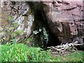
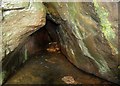
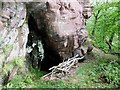
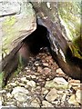
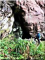
A Rock Shelter consisting of 2 small Caves in the Sandstone Cliffs of Hawking Craig, at Hunterston in Ayrshire.
Hawking Cave is referred to locally as 'The Holy Cave', it has associations with Irish Monk Kentigern, now known as St. Mungo - founder of Glaschu in the ancient kingdom of Strathclyde. To the South is a 2nd cave called Smiths Cave (Named after "John Smith" ~ author of 1895 book 'Prehistoric Man in Ayrshire')
The entrance to Hawking Cave is about 3m above the level of the old raised beach that runs down to the sea. In 1879 the cave was excavated, the size of the cave at the entrance is 1.8m x 1.8m and this extends 8.2m deep. The back 4.5m were excavated to a depth of 1.8m. Three "floors" were visible, One at 45cm, another at 75cm, and the third 1m deep, indicating three different periods of occupation.
Each was formed of layers of Sea Shells on layers of Ashes on trodden sand. Deer, Pig, Sheep, Ox, and Goat Bones were found at all levels, Horse Bones between the upper and second, and Dog Bones between the middle and third floors. Bone, Flint and Slate Objects were found along with some Pottery and a bit of Slag in the debris. The Pottery included a coarse, unglazed, Reddish type and a thinner, better type with a Green glaze.
From Hawking Cave you look directly West across to Lesser Cumbrae 2.75km away, which was once attached to the mainland before sea levels rose after the last Ice Age.
Records of "J. Paterson" from 1866 show that a Cairn used to stand on the level piece of ground between Hawking Craig and the sea. He notes that some Cists & Urns with Human Remains were also found in the vicinity of Hawking Craig. As well as an Axe Hammer and a Flint Point, the famous Hunterston Brooch was also found near Hawking Craig.
For more information : Canmore ID 40667
You may be viewing yesterday's version of this page. To see the most up to date information please register for a free account.
Do not use the above information on other web sites or publications without permission of the contributor.
Nearby Images from Geograph Britain and Ireland:
©2017(licence)
©2017(licence)
©2017(licence)
©2018(licence)
©2020(licence)
The above images may not be of the site on this page, they are loaded from Geograph.
Please Submit an Image of this site or go out and take one for us!
Click here to see more info for this site
Nearby sites
Key: Red: member's photo, Blue: 3rd party photo, Yellow: other image, Green: no photo - please go there and take one, Grey: site destroyed
Download sites to:
KML (Google Earth)
GPX (GPS waypoints)
CSV (Garmin/Navman)
CSV (Excel)
To unlock full downloads you need to sign up as a Contributory Member. Otherwise downloads are limited to 50 sites.
Turn off the page maps and other distractions
Nearby sites listing. In the following links * = Image available
1.7km S 181° Auld Hill Fort (Portencross) Hillfort (NS17834910)
3.4km ENE 67° Biglees Cairn Cairn (NS21125196)
3.6km ENE 76° Glentane Standing Stones Standing Stones (NS21445152)
4.2km NE 48° Southannan 2 Rock Art (NS21205350)
4.3km SE 145° Seamill Fort* Promontory Fort / Cliff Castle (NS20314715)
4.6km NE 46° Southannan 1 Rock Art (NS21395390)
4.8km NE 46° Southannan Menhir Standing Stone (Menhir) (NS21535392)
5.0km E 83° Caldron Cairn Cairn (NS22905115)
5.2km E 85° Little Caldron Cairn Cairn (NS23155100)
5.4km ENE 59° Kaim Hill Cairn Cairn (NS22715342)
5.6km N 354° Gouklan Stone Standing Stone (Menhir) (NS17615641)
5.7km ESE 113° Blackshaw Rock Art* Rock Art (NS23104834)
6.3km NNW 347° Glaid Stone* Natural Stone / Erratic / Other Natural Feature (NS16765700)
8.0km ESE 116° Blackshaw Moor Stone Circle (NS250470)
8.2km NNE 15° Broomfields Menhir Standing Stone (Menhir) (NS20475864)
8.3km N 359° Tomont End Cairns, Isle of Great Cumbrae* Cairn (NS182591)
8.3km NNE 19° Haylie* Chambered Cairn (NS2094558592)
8.6km NNE 33° Fechan Menhir Standing Stone (Menhir) (NS22975775)
8.8km NNE 22° Castle Hill Fort (Largs)* Hillfort (NS2156558800)
8.8km WNW 285° St Blane's Chapel (Isle of Bute)* Ancient Cross (NS0949853405)
8.9km WNW 285° St Blane's Well* Ancient Cross (NS0944253442)
8.9km WNW 285° St Blane's Broch* Broch or Nuraghe (NS094534)
9.3km SE 125° Knockrivoch Mount Barrow Cemetery (NS25344510)
9.6km WNW 282° Dunagoil* Burial Chamber or Dolmen (NS08595322)
9.7km WNW 282° Dunagoil hillfort* Vitrified Fort (NS0847953127)
View more nearby sites and additional images


 We would like to know more about this location. Please feel free to add a brief description and any relevant information in your own language.
 Wir möchten mehr über diese Stätte erfahren. Bitte zögern Sie nicht, eine kurze Beschreibung und relevante Informationen in Deutsch hinzuzufügen.
 Nous aimerions en savoir encore un peu sur les lieux. S'il vous plaît n'hesitez pas à ajouter une courte description et tous les renseignements pertinents dans votre propre langue.
 Quisieramos informarnos un poco más de las lugares. No dude en añadir una breve descripción y otros datos relevantes en su propio idioma.