

<< Our Photo Pages >> Caerloggas Down Circle - Modern Stone Circle etc in England in Cornwall
Submitted by theCaptain on Monday, 03 December 2012 Page Views: 6058
Modern SitesSite Name: Caerloggas Down CircleCountry: England
NOTE: This site is 1.411 km away from the location you searched for.
County: Cornwall Type: Modern Stone Circle etc
Nearest Town: St Austell Nearest Village: Stenalees
Map Ref: SX01635635
Latitude: 50.373520N Longitude: 4.791087W
Condition:
| 5 | Perfect |
| 4 | Almost Perfect |
| 3 | Reasonable but with some damage |
| 2 | Ruined but still recognisable as an ancient site |
| 1 | Pretty much destroyed, possibly visible as crop marks |
| 0 | No data. |
| -1 | Completely destroyed |
| 5 | Superb |
| 4 | Good |
| 3 | Ordinary |
| 2 | Not Good |
| 1 | Awful |
| 0 | No data. |
| 5 | Can be driven to, probably with disabled access |
| 4 | Short walk on a footpath |
| 3 | Requiring a bit more of a walk |
| 2 | A long walk |
| 1 | In the middle of nowhere, a nightmare to find |
| 0 | No data. |
| 5 | co-ordinates taken by GPS or official recorded co-ordinates |
| 4 | co-ordinates scaled from a detailed map |
| 3 | co-ordinates scaled from a bad map |
| 2 | co-ordinates of the nearest village |
| 1 | co-ordinates of the nearest town |
| 0 | no data |
Internal Links:
External Links:
I have visited· I would like to visit
43559959 would like to visit
TheCaptain has visited here
")
Driving back from the Eden Project, and marked on the OS Map is a viewpoint at the top of Carloggas Down, so went for a look and the views are tremendous. All around are the old china clay quarrying scars, but to the south can see all the way to the sea, very clear in the southeast is St Austell Bay and the daymark on Gribbin is almost shining in the light. Triffic.
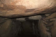
Hold on, whats this? There are stones. Its a whole circle. Some of these stones look like proper old standers, but the circle is obviously a new construction.
There's a chap walking his dog, so ask him about it. The hill is a real hill, but was quarried and dumped on all around for centuries, and over the last 10 to 20 years it has all been relandscaped and made into this lovely spot. He said that the whole region is being cleaned up massively, with outdoor trails etc put in linking it all up. Must be costing a fortune to do all of this, but what good work.
Note: Stone circle erected on the top of Caerloggas Down which has been extensively relandscaped following centuries of China Clay quarrying. I wonder whether there was a circle or suchlike here before all the destruction?
You may be viewing yesterday's version of this page. To see the most up to date information please register for a free account.
")
")
")
")
")
")
")
Do not use the above information on other web sites or publications without permission of the contributor.
Click here to see more info for this site
Nearby sites
Key: Red: member's photo, Blue: 3rd party photo, Yellow: other image, Green: no photo - please go there and take one, Grey: site destroyed
Download sites to:
KML (Google Earth)
GPX (GPS waypoints)
CSV (Garmin/Navman)
CSV (Excel)
To unlock full downloads you need to sign up as a Contributory Member. Otherwise downloads are limited to 50 sites.
Turn off the page maps and other distractions
Nearby sites listing. In the following links * = Image available
165m NNE 23° Caerloggas Barrow III Timber Circle (SX017565)
165m NNE 23° Caerloggas Barrow I Timber Circle (SX017565)
178m NE 39° Caerloggas Down longstone* Modern Stone Circle etc (SX0174756485)
2.1km SE 125° Carn Grey* Rock Outcrop (SX033551)
2.3km WNW 299° Hensbarrow* Round Barrow(s) (SW99685754)
2.6km SE 134° Menear* Standing Stone (Menhir) (SX0345154469)
3.1km S 186° Menacuddle* Holy Well or Sacred Spring (SX0118753260)
3.1km W 267° Cocksbarrow Timber Circle (SW985563)
3.9km NE 51° Luxulyan stones* Natural Stone / Erratic / Other Natural Feature (SX0474658699)
3.9km ENE 62° Luxulyan Cross* Ancient Cross (SX05185806)
4.0km S 181° The Mengu Stone* Marker Stone (SX014524)
4.1km ENE 64° St Cyors's Well* Holy Well or Sacred Spring (SX054580)
4.1km NW 320° Roche Rock* Rock Outcrop (SW99105962)
4.3km E 98° Prideaux Camp* Hillfort (SX059556)
4.4km SSE 160° Gwallon Longstone* Standing Stone (Menhir) (SX02965212)
4.4km NW 318° Roche Cross* Ancient Cross (SW98795978)
4.8km NW 320° Menevegar Menhir* Standing Stone (Menhir) (SW98676011)
4.9km SSW 203° St Mewan's Well* Holy Well or Sacred Spring (SW995519)
6.0km WSW 250° St Stephens Beacon* Hillfort (SW959545)
6.2km NNW 328° St Gundred's Well* Holy Well or Sacred Spring (SW985617)
6.2km ENE 65° Trethew Cross* Ancient Cross (SX07355881)
6.2km SW 233° Langerth Round* Ancient Village or Settlement (SW96515277)
6.3km N 9° Castilly Tumulus* Round Barrow(s) (SX02846258)
6.6km N 11° Castilly Henge* Henge (SX03116274)
6.7km ENE 65° St Bryvyth's Well* Holy Well or Sacred Spring (SX078590)
View more nearby sites and additional images


 We would like to know more about this location. Please feel free to add a brief description and any relevant information in your own language.
 Wir möchten mehr über diese Stätte erfahren. Bitte zögern Sie nicht, eine kurze Beschreibung und relevante Informationen in Deutsch hinzuzufügen.
 Nous aimerions en savoir encore un peu sur les lieux. S'il vous plaît n'hesitez pas à ajouter une courte description et tous les renseignements pertinents dans votre propre langue.
 Quisieramos informarnos un poco más de las lugares. No dude en añadir una breve descripción y otros datos relevantes en su propio idioma.