Featured: Explore Scotland (and everywhere else) with our Megalithic Portal iPhone app

Explore Scotland (and everywhere else) with our Megalithic Portal iPhone app

Random Image


Garde Epée Dolmen

Art as Metaphor: The Prehistoric Rock-art of Britain

Art as Metaphor: The Prehistoric Rock-art of Britain

Who's Online

There are currently, 308 guests and 2 members online.

You are a guest. To join in, please register for free by clicking here

Sponsors

<< Our Photo Pages >> Castell Mawr (Pembrokeshire) - Hillfort in Wales in Pembrokeshire

Submitted by Andy B on Wednesday, 05 July 2023  Page Views: 14172

Iron Age and Later PrehistorySite Name: Castell Mawr (Pembrokeshire)
Country: Wales County: Pembrokeshire Type: Hillfort
Nearest Town: Newport  Nearest Village: Eglwyswrw
Map Ref: SN11873776  Landranger Map Number: 145
Latitude: 52.006308N  Longitude: 4.742369W
Condition:
5Perfect
4Almost Perfect
3Reasonable but with some damage
2Ruined but still recognisable as an ancient site
1Pretty much destroyed, possibly visible as crop marks
0No data.
-1Completely destroyed
3 Ambience:
5Superb
4Good
3Ordinary
2Not Good
1Awful
0No data.
4 Access:
5Can be driven to, probably with disabled access
4Short walk on a footpath
3Requiring a bit more of a walk
2A long walk
1In the middle of nowhere, a nightmare to find
0No data.
2 Accuracy:
5co-ordinates taken by GPS or official recorded co-ordinates
4co-ordinates scaled from a detailed map
3co-ordinates scaled from a bad map
2co-ordinates of the nearest village
1co-ordinates of the nearest town
0no data
5

Internal Links:
External Links:

Castell Mawr (Pembrokeshire)
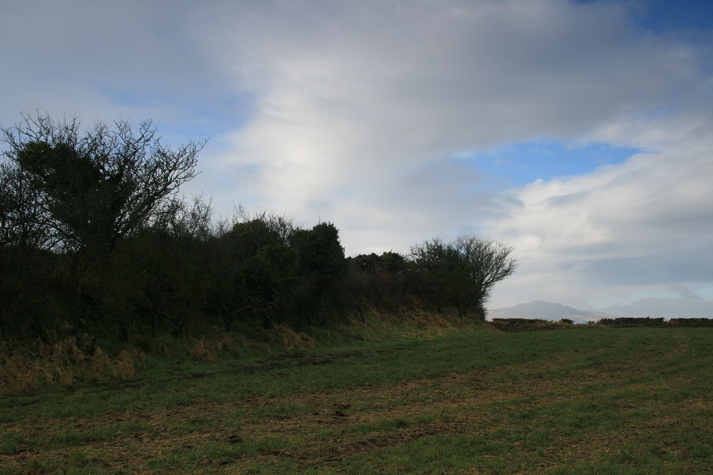
Castell Mawr (Pembrokeshire) submitted by Horatio : A hillfort looking very suspiciously like a neolithic henge. In 1988 Harold Mytum and Chris Webster, archaeologists from the Universities of York and Southampton, published a report of their geophysical survey of the site. They concluded that Castell Mawr could be reinterpreted as a Late Neolithic/Early Bronze Age henge, which was later re-used in the Iron Age as farmstead. However excavations i... (Vote or comment on this photo)
In parts the ditch of Castell Mawr iron age fort can be seen on the inside of the main bank. This caused archaeologists to think the site might have been a henge that was later remodelled into a hillfort.

A survey, geophysics and excavation was carried out at the site in 2012 led by Prof. Mike Parker-Pearson, investigating the idea this might have been a staging post on the route to Stonehenge for the bluestones from Craig Rhosyfelin and the other purported quarrying sites. Sadly for Mike, the team and his theory, no definite evidence of any Neolithic activity was found, and the earthworks all date to the Iron Age. See the comments section below for more details

Page originally by Vicky
You may be viewing yesterday's version of this page. To see the most up to date information please register for a free account.

Castell Mawr (Pembrokeshire)
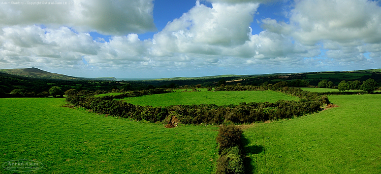
Castell Mawr (Pembrokeshire) submitted by Aerial-Cam : The later prehistoric enclosure or hillfort that may have been a much earlier henge originally - Castell Mawr in Pembrokeshire, with a view over it to Carningli, Dinas Head and the bay at Newport. (Vote or comment on this photo)

Castell Mawr (Pembrokeshire)
Castell Mawr (Pembrokeshire) submitted by Horatio : This Iron age fort/late Neolithic henge (prefer henge) as seen from the south, in the very top left corner of the photo is Castell Henlys Iron age fort (in the clearing of the trees) (1 comment - Vote or comment on this photo)

Castell Mawr (Pembrokeshire)
Castell Mawr (Pembrokeshire) submitted by Hayden : Picture of Castell Mawr taken from Castell Bach (Vote or comment on this photo)

Castell Mawr (Pembrokeshire)
Castell Mawr (Pembrokeshire) submitted by postman : Outside the ring looking up at the what was then well a overgrown bank. Mid February 2010. (Vote or comment on this photo)

Castell Mawr (Pembrokeshire)
Castell Mawr (Pembrokeshire) submitted by postman : Mid February 2010, the better entrance.

Castell Mawr (Pembrokeshire)
Castell Mawr (Pembrokeshire) submitted by postman : Mid February 2010, the unpassable less well defined entrance.

Castell Mawr (Pembrokeshire)
Castell Mawr (Pembrokeshire) submitted by postman : Mid February 2010, following the gorse covered bank round.

Castell Mawr (Pembrokeshire)
Castell Mawr (Pembrokeshire) submitted by Bladup : The bank at Castell Mawr, The Preseli's are in the background.

Castell Mawr (Pembrokeshire)
Castell Mawr (Pembrokeshire) submitted by Bladup : Castell Mawr fort.

Castell Mawr (Pembrokeshire)
Castell Mawr (Pembrokeshire) submitted by Bladup

Castell Mawr (Pembrokeshire)
Castell Mawr (Pembrokeshire) submitted by Bladup : Castell Mawr iron age fort, The ditch on the inside of the bank again, Therefore showing that the site was maybe once a neolithic henge that was later remodelled into a fort.

Castell Mawr (Pembrokeshire)
Castell Mawr (Pembrokeshire) submitted by Bladup : Castell Mawr fort, It was maybe once a henge, The bank does look outside the ditch in this part of the fort, It's Carn Ingli in the background

Castell Mawr (Pembrokeshire)
Castell Mawr (Pembrokeshire) submitted by Bladup : The iron age bank in the middle of Castell Mawr fort [maybe a remodelled neolithic henge].

Castell Mawr (Pembrokeshire)
Castell Mawr (Pembrokeshire) submitted by Bladup : The Bank of Castell Mawr fort.

Castell Mawr (Pembrokeshire)
Castell Mawr (Pembrokeshire) submitted by Bladup : The banks and ditch of Castell Mawr, An iron age fort maybe remodelled from an earlier henge.

Do not use the above information on other web sites or publications without permission of the contributor.
Click here to see more info for this site

Nearby sites

Click here to view sites on an interactive OS map

Key: Red: member's photo, Blue: 3rd party photo, Yellow: other image, Green: no photo - please go there and take one, Grey: site destroyed

Download sites to:
KML (Google Earth)
GPX (GPS waypoints)
CSV (Garmin/Navman)
CSV (Excel)

To unlock full downloads you need to sign up as a Contributory Member. Otherwise downloads are limited to 50 sites.


Turn off the page maps and other distractions

Nearby sites listing. In the following links * = Image available
 461m S 174° Penybenglog fort Hillfort (SN119373)
 590m WSW 252° Castell Llwyd Ancient Village or Settlement (SN113376)
 984m N 352° St Dogfaels Well Holy Well or Sacred Spring (SN11773874)
 1.3km N 4° Penpedwast Ancient Village or Settlement (SN12013903)
 1.3km N 351° Castell Henllys* Promontory Fort / Cliff Castle (SN11723905)
 1.6km S 186° Craig Rhosyfelin* Rock Outcrop (SN11653614)
 1.7km E 83° Cerrig-Y-Derwyddon* Standing Stone (Menhir) (SN13593790)
 2.1km WSW 247° Pentre Ifan* Portal Tomb (SN09943702)
 2.1km WSW 244° Penfeidr Coedan* Ancient Mine, Quarry or other Industry (SN099369)
 2.1km WSW 244° Penfeidr Coedan Stone* Standing Stone (Menhir) (SN099369)
 2.2km ENE 70° Ffynnon Fair (Pembrokeshire) Holy Well or Sacred Spring (SN13953843)
 2.4km NW 321° Cwm Gloyne Hillfort (SN104397)
 2.7km SSW 192° Brynberian Round Barrow(s) (SN112351)
 3.0km WSW 247° Tycanol Hillfort (SN091367)
 3.0km NW 326° Trefael* Rock Art (SN10294028)
 3.0km WSW 239° Carnedd Meibion Owen Tor 3* Natural Stone / Erratic / Other Natural Feature (SN092363)
 3.4km SSW 197° Bedd yr Afanc* Passage Grave (SN10793458)
 3.4km SW 230° St Brynach's Well Holy Well or Sacred Spring (SN09173568)
 3.5km SW 232° Penlan Stone Pair* Standing Stones (SN09033575)
 3.6km SW 228° The Penlan Stone* Standing Stone (Menhir) (SN09053545)
 3.7km SW 235° Troed y rhiw Stone Row / Alignment (SN0879235756)
 3.8km N 7° Crugiau Cemaes* Barrow Cemetery (SN125415)
 4.0km NNW 348° Caer Bayvil* Hillfort (SN112417)
 4.2km SE 129° Lach y Fleiddast Burial Chamber or Dolmen (SN1535)
 4.2km WNW 301° Nevern Churchyard* Standing Stone (Menhir) (SN0833340028)
View more nearby sites and additional images

<< Schälchenstein Marienwerder

Great Cursus W Barrow >>

Please add your thoughts on this site

Prehistoric Rock Art in the Northern Dales

Prehistoric Rock Art in the Northern Dales

Sponsors

Auto-Translation (Google)

Translate from English into:

"Castell Mawr (Pembrokeshire)" | Login/Create an Account | 3 News and Comments
  
Go back to top of page    Comments are owned by the poster. We aren't responsible for their content.
Excavations at Castell Mawr Iron Age hillfort, Pembrokeshire. by Andy B on Wednesday, 05 July 2023
(User Info | Send a Message)
Excavations at Castell Mawr Iron Age hillfort, Pembrokeshire by Parker Pearson, M, Casswell, C. and Welham, K., 2017. . Archaeologia Cambrensis, 166

Castell Mawr is a small hillfort in the community of Eglwyswrw, Pembrokeshire. Thought to have been built on a Late Neolithic henge, it was investigated with four trenches in 2012–13. These excavations revealed that Castell Mawr’s main period of construction and use was in the Earliest/Early Iron Age during the late eighth–late fifth centuries BC with hints of an earlier human presence on the hilltop in the Late Mesolithic and Bronze Age. No definite evidence of any Neolithic activity was found, however, and the earthworks all date to the Iron Age.

The hillfort’s Iron Age sequence started with a roundhouse, followed by a pair of concentric timber palisades built during the late eighth–late fifth centuries BC. An enclosing rampart was constructed around the hilltop, followed by a cross-bank. The final activity post-dating the cross-bank dates to the fifth century BC, slightly earlier than or contemporary with initial construction at nearby Castell Henllys. The Castell Mawr/Castell Henllys sequence confirms Murphy and Mytum’s (2012) model for long-term processes of settlement development in west Wales.
More at http://eprints.bournemouth.ac.uk/29616/

Paper:
https://eprints.bournemouth.ac.uk/29616/1/AC166%20141-173%E2%80%93Pearson%20et%20al.pdf
[ Reply to This ]

Re: Castell Mawr by sem on Friday, 02 June 2017
(User Info | Send a Message)
OS grid ref (Coflein) SN1187537768
Coflein "Castell Mawr is generally considered to be a later Prehistoric settlement enclosure, possibly of two phases, although it has been suggested that it is an earlier ritual or ceremonial henge enclosure reused in the Iron Age. The site was subject to partial geophysical survey in 1988."
[ Reply to This ]

Re: Castell Mawr by coldrum on Wednesday, 06 January 2010
(User Info | Send a Message)
Coflein site entry.

http://www.coflein.gov.uk/en/site/304047/details/CASTELL+MAWR%2C+MELINE/
[ Reply to This ]

Your Name: Anonymous [ Register Now ]
Subject:


Add your comment or contribution to this page. Spam or offensive posts are deleted immediately, don't even bother

<<< What is five plus one as a number? (Please type the answer to this question in the little box on the left)
You can also embed videos and other things. For Youtube please copy and paste the 'embed code'.
For Google Street View please include Street View in the text.
Create a web link like this: <a href="https://www.megalithic.co.uk">This is a link</a>  

Allowed HTML is:
<p> <b> <i> <a> <img> <em> <br> <strong> <blockquote> <tt> <li> <ol> <ul> <object> <param> <embed> <iframe>

We would like to know more about this location. Please feel free to add a brief description and any relevant information in your own language.
Wir möchten mehr über diese Stätte erfahren. Bitte zögern Sie nicht, eine kurze Beschreibung und relevante Informationen in Deutsch hinzuzufügen.
Nous aimerions en savoir encore un peu sur les lieux. S'il vous plaît n'hesitez pas à ajouter une courte description et tous les renseignements pertinents dans votre propre langue.
Quisieramos informarnos un poco más de las lugares. No dude en añadir una breve descripción y otros datos relevantes en su propio idioma.