

<< Our Photo Pages >> Shemore - Rock Art in Scotland in Argyll
Submitted by hamish on Saturday, 28 May 2005 Page Views: 7311
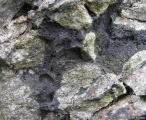
Rock ArtSite Name: ShemoreCountry: Scotland County: Argyll Type: Rock Art
Nearest Town: Helensburgh Nearest Village: Arden
Map Ref: NS349882
Latitude: 56.058080N Longitude: 4.653036W
Condition:
| 5 | Perfect |
| 4 | Almost Perfect |
| 3 | Reasonable but with some damage |
| 2 | Ruined but still recognisable as an ancient site |
| 1 | Pretty much destroyed, possibly visible as crop marks |
| 0 | No data. |
| -1 | Completely destroyed |
| 5 | Superb |
| 4 | Good |
| 3 | Ordinary |
| 2 | Not Good |
| 1 | Awful |
| 0 | No data. |
| 5 | Can be driven to, probably with disabled access |
| 4 | Short walk on a footpath |
| 3 | Requiring a bit more of a walk |
| 2 | A long walk |
| 1 | In the middle of nowhere, a nightmare to find |
| 0 | No data. |
| 5 | co-ordinates taken by GPS or official recorded co-ordinates |
| 4 | co-ordinates scaled from a detailed map |
| 3 | co-ordinates scaled from a bad map |
| 2 | co-ordinates of the nearest village |
| 1 | co-ordinates of the nearest town |
| 0 | no data |
Internal Links:
External Links:
I have visited· I would like to visit
custer visited on 8th Sep 2013 - their rating: Cond: 3 Amb: 2 Access: 3 Park at bottom of hill in layby, Short walk up the hill cross the road at top of runnaway lane and stone is just over the fence. Signpost just behing the stone can be seen from the road when braken has died down..
hamish have visited here
")
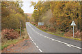
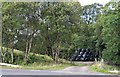
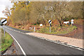
If travelling north take the road to Garelochhead after Arden. There are trees on the right, where the trees end there is the stone. There is nowhere to park so be careful. I think this is called Argyll and Bute now.
You may be viewing yesterday's version of this page. To see the most up to date information please register for a free account.
")
")
Do not use the above information on other web sites or publications without permission of the contributor.
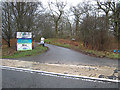
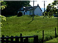
Nearby Images from Geograph Britain and Ireland:
©2010(licence)
©2019(licence)
©2010(licence)
©2007(licence)
©2007(licence)
The above images may not be of the site on this page, they are loaded from Geograph.
Please Submit an Image of this site or go out and take one for us!
Click here to see more info for this site
Nearby sites
Key: Red: member's photo, Blue: 3rd party photo, Yellow: other image, Green: no photo - please go there and take one, Grey: site destroyed
Download sites to:
KML (Google Earth)
GPX (GPS waypoints)
CSV (Garmin/Navman)
CSV (Excel)
To unlock full downloads you need to sign up as a Contributory Member. Otherwise downloads are limited to 50 sites.
Turn off the page maps and other distractions
Nearby sites listing. In the following links * = Image available
4.8km NNE 12° St Kessog's Church* Sculptured Stone (NS36129286)
6.0km SSE 158° Round Hill (Cameron home farm cairn)* Cairn (NS36918252)
6.4km SSE 157° Cameron Farm* Chambered Cairn (NS372822)
9.0km SSE 163° Carman Hill Fort* Hillfort (NS37207944)
9.6km S 182° St Mahew’s Cross* Standing Stone (Menhir) (NS34207863)
9.9km E 91° St Ronan's Well Holy Well or Sacred Spring (NS4478087647)
10.1km S 170° Carman Hill cairn* Chambered Cairn (NS36357815)
11.2km N 352° Fairy Loch (Tarbet, Argyll) Holy Well or Sacred Spring (NS3384299392)
11.8km ESE 117° Gallangad Muir Standing Stone* Standing Stone (Menhir)
12.8km ESE 119° Lang Cairn* Chambered Cairn (NS458815)
13.3km ESE 122° Shiels of Gartlea* Chambered Cairn (NS459807)
14.6km S 182° Bogle Stane* Natural Stone / Erratic / Other Natural Feature (NS3370773634)
14.7km SSE 158° Dumbarton Hilllfort* Hillfort (NS399744)
14.7km ESE 116° Aucheneck* Chambered Cairn (NS4793681308)
14.9km SSE 149° Dumbuie Dun* Hillfort (NS42187517)
14.9km SW 224° Granny Kempock Standing Stone* Standing Stone (Menhir) (NS2407877856)
15.0km SSE 165° Langbank Crannog (West)* Crannog (NS3813073550)
15.1km SSW 207° Whinhill Cup Marks Rock Art (NS2759074923)
15.6km S 190° Harelaw Cairn Cairn (NS3155572939)
15.7km SSE 153° Dumbuck Crannog* Crannog (NS41577392)
15.7km S 186° Devol Moor Ancient Village or Settlement (NS3269872597)
15.9km S 177° High Castlehill Fort Hillfort (NS3505972281)
16.0km SW 214° Bunston Knowe* Modern Stone Circle etc (NS25457530)
16.0km SSE 157° Langbank Crannog (East)* Crannog (NS4049773171)
16.0km SE 146° Greenland 1 Rock Art (NS43447460)
View more nearby sites and additional images


 We would like to know more about this location. Please feel free to add a brief description and any relevant information in your own language.
 Wir möchten mehr über diese Stätte erfahren. Bitte zögern Sie nicht, eine kurze Beschreibung und relevante Informationen in Deutsch hinzuzufügen.
 Nous aimerions en savoir encore un peu sur les lieux. S'il vous plaît n'hesitez pas à ajouter une courte description et tous les renseignements pertinents dans votre propre langue.
 Quisieramos informarnos un poco más de las lugares. No dude en añadir una breve descripción y otros datos relevantes en su propio idioma.