

<< Our Photo Pages >> St Patrick’s Isle and Monk's Tower - Early Christian Sculptured Stone in Channel Islands and Isle of Man in Isle of Man
Submitted by TheDruid-3X3 on Thursday, 21 May 2020 Page Views: 1575
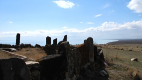
Early Medieval (Dark Age)Site Name: St Patrick’s Isle and Monk's Tower Alternative Name: Peel Castle TowerCountry: Channel Islands and Isle of Man Island: Isle of Man Type: Early Christian Sculptured Stone
Nearest Town: Peel
Latitude: 54.225705N Longitude: 4.698554W
Condition:
| 5 | Perfect |
| 4 | Almost Perfect |
| 3 | Reasonable but with some damage |
| 2 | Ruined but still recognisable as an ancient site |
| 1 | Pretty much destroyed, possibly visible as crop marks |
| 0 | No data. |
| -1 | Completely destroyed |
| 5 | Superb |
| 4 | Good |
| 3 | Ordinary |
| 2 | Not Good |
| 1 | Awful |
| 0 | No data. |
| 5 | Can be driven to, probably with disabled access |
| 4 | Short walk on a footpath |
| 3 | Requiring a bit more of a walk |
| 2 | A long walk |
| 1 | In the middle of nowhere, a nightmare to find |
| 0 | No data. |
| 5 | co-ordinates taken by GPS or official recorded co-ordinates |
| 4 | co-ordinates scaled from a detailed map |
| 3 | co-ordinates scaled from a bad map |
| 2 | co-ordinates of the nearest village |
| 1 | co-ordinates of the nearest town |
| 0 | no data |
Internal Links:
External Links:
")
As far as I recall from my 2006 Tour of the Peel Castle, the Tower was built in around the 1100s.
St Patrick’s Isle began as a religious settlement when Irish monks arrived here around 500AD and founded a Monastery. It has been a burial site since the C7th. The first buildings would have been made of wood but were later replaced by stone. There is evidence of Iron Age timber dwellings from 600BC.
Also on the isle is St German’s cathedral built 1240. Later the church buildings were requisitioned by the military and used as a fortress, which was much extended and added to. By the late 1840s, the curtain wall was in a perilous state, the castle was no longer needed for defensive purposes and abandoned.
You may be viewing yesterday's version of this page. To see the most up to date information please register for a free account.
")
")
")
Do not use the above information on other web sites or publications without permission of the contributor.
Nearby Images from Flickr


The above images may not be of the site on this page, but were taken nearby. They are loaded from Flickr so please click on them for image credits.
Click here to see more info for this site
Nearby sites
Click here to view sites on an interactive map of the areaKey: Red: member's photo, Blue: 3rd party photo, Yellow: other image, Green: no photo - please go there and take one, Grey: site destroyed
Download sites to:
KML (Google Earth)
GPX (GPS waypoints)
CSV (Garmin/Navman)
CSV (Excel)
To unlock full downloads you need to sign up as a Contributory Member. Otherwise downloads are limited to 50 sites.
Turn off the page maps and other distractions
Nearby sites listing. In the following links * = Image available
635m SSW 213° Peel Hill round mounds* Cairn
1.7km SSW 207° Corrin's Tower* Modern Stone Circle etc
3.3km E 80° Staarvey Farm Cist burial Cist
3.4km ESE 106° Giant's Grave (Isle of Man)* Chambered Tomb (SC27438340)
3.4km E 80° Meir ny Foawr (Knocksharry) Stone Circle (SC27588495)
4.4km ESE 123° Giant's grave (St John's)* Cist (SC27758193)
4.5km ESE 124° Ballaharra stones Burial Chamber or Dolmen
5.4km NE 55° Ballakaighen* Ancient Village or Settlement (SC287874)
5.6km NE 55° Corvalley Cairn* Cairn (SC28938747)
6.5km ESE 122° Chibbyr Roney* Holy Well or Sacred Spring (SC296808)
7.8km NE 51° Michael Standing Stone and rock art* Standing Stone (Menhir) (SC30468908)
8.6km NE 53° Cronk Guckley mounds* Round Barrow(s) (SC31238945)
8.7km ESE 117° St Trinian's Chapel (Marown) Ancient Cross (SC31778023)
9.8km SE 124° Marown Old Church Holy Well or Sacred Spring (SC3215378674)
9.9km SE 129° St. Patrick's Chair* Early Christian Sculptured Stone (SC3165577946)
9.9km ESE 113° Keill Vreeshey (Crosby) Sculptured Stone (SC332802)
10.0km SE 130° St Ronan's Well Holy Well or Sacred Spring (SC3162077766)
11.4km SE 131° Braaid Circle* Ancient Village or Settlement (SC325766)
11.5km SE 131° The Braaid* Ancient Village or Settlement (SC32517655)
11.8km ESE 118° White Lady of Ballafreer* Standing Stone (Menhir)
11.9km ENE 72° Druidale* Ancient Village or Settlement (SC356878)
12.1km NE 40° Orrisdale* Cairn (SC323935)
12.6km S 170° Chibbyr Undin* Holy Well or Sacred Spring (SC2672)
12.8km NE 44° Magher ny Clogh Mooar* Standing Stone (Menhir) (SC335933)
12.9km S 187° Ballakilpheric* Standing Stone (Menhir) (SC222717)
View more nearby sites and additional images
<< Long Mortuary Enclosure, 800mtr West of Freshwater Bay House


 We would like to know more about this location. Please feel free to add a brief description and any relevant information in your own language.
 Wir möchten mehr über diese Stätte erfahren. Bitte zögern Sie nicht, eine kurze Beschreibung und relevante Informationen in Deutsch hinzuzufügen.
 Nous aimerions en savoir encore un peu sur les lieux. S'il vous plaît n'hesitez pas à ajouter une courte description et tous les renseignements pertinents dans votre propre langue.
 Quisieramos informarnos un poco más de las lugares. No dude en añadir una breve descripción y otros datos relevantes en su propio idioma.