


<< Image Pages >> Cleaves Cove - Cave or Rock Shelter in Scotland in North Ayrshire
Submitted by durhamnature on Sunday, 07 October 2012 Page Views: 7621
Natural PlacesSite Name: Cleaves Cove Alternative Name: Ceeves CaveCountry: Scotland County: North Ayrshire Type: Cave or Rock Shelter
Map Ref: NS31774744
Latitude: 55.691171N Longitude: 4.677924W
Condition:
| 5 | Perfect |
| 4 | Almost Perfect |
| 3 | Reasonable but with some damage |
| 2 | Ruined but still recognisable as an ancient site |
| 1 | Pretty much destroyed, possibly visible as crop marks |
| 0 | No data. |
| -1 | Completely destroyed |
| 5 | Superb |
| 4 | Good |
| 3 | Ordinary |
| 2 | Not Good |
| 1 | Awful |
| 0 | No data. |
| 5 | Can be driven to, probably with disabled access |
| 4 | Short walk on a footpath |
| 3 | Requiring a bit more of a walk |
| 2 | A long walk |
| 1 | In the middle of nowhere, a nightmare to find |
| 0 | No data. |
| 5 | co-ordinates taken by GPS or official recorded co-ordinates |
| 4 | co-ordinates scaled from a detailed map |
| 3 | co-ordinates scaled from a bad map |
| 2 | co-ordinates of the nearest village |
| 1 | co-ordinates of the nearest town |
| 0 | no data |
Internal Links:
External Links:
")
Canmore Site 42038
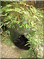
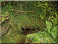
Cleaves Cove, is a limestone cavern situated at 51m above sea level on the south side of Dusk Glen. Some sections were made in the deposits in several of the passages by Smith in 1883.
Among the relics found were the following: Surface Deposit - A silver ring, an emerald colour glass bead, a bronze finger ring, an iron spearhead, and fragments of "rude black pottery", wheel turned and milk glazed. From the Second Deposit came a worked fragment of red deer horn, a polished deer horn implement, and a small bone implement. Other finds include two bronze spiral rings, listed among Viking material by Shetelig, but regarded as undatable by Clarke. Also a flint knife, a shale spindle whorl, a chert axe, a bone spoon, and numerous bones. A collection of relics from the cave was donated to the National Museum of Antiquities of Scotland (NMAS) in 1931.
Text updated and summarised from Canmore.
You may be viewing yesterday's version of this page. To see the most up to date information please register for a free account.
")
")
Do not use the above information on other web sites or publications without permission of the contributor.
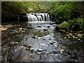
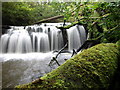
Nearby Images from Geograph Britain and Ireland:
©2008(licence)
©2008(licence)
©2008(licence)
©2008(licence)
©2008(licence)
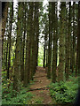
The above images may not be of the site on this page, they are loaded from Geograph.
Please Submit an Image of this site or go out and take one for us!
Click here to see more info for this site
Nearby sites
Key: Red: member's photo, Blue: 3rd party photo, Yellow: other image, Green: no photo - please go there and take one, Grey: site destroyed
Download sites to:
KML (Google Earth)
GPX (GPS waypoints)
CSV (Garmin/Navman)
CSV (Excel)
To unlock full downloads you need to sign up as a Contributory Member. Otherwise downloads are limited to 50 sites.
Turn off the page maps and other distractions
Nearby sites listing. In the following links * = Image available
3.3km NW 308° Courthill Cairn* Round Barrow(s) (NS29244958)
5.2km SW 231° Ashgrove Loch Crannog* Crannog (NS27594431)
5.2km S 172° Eglinton Park Ancient Village or Settlement (NS3229642217)
5.2km S 190° Dirrans burial* Cist (NS30684230)
5.9km SSW 203° Todhill Crannog Crannog (NS2930042101)
6.1km N 3° Kilbirnie Crannog Crannog (NS32385356)
6.2km NNW 328° Carwinning Hill Hillfort (NS28715286)
6.2km WSW 238° Diddup Hillfort Hillfort (NS2636344331)
6.3km SSE 157° Sourlie Hill Modern Stone Circle etc (NS3398041490)
6.6km SSW 214° Dubbs Cist Cist (NS27884208)
6.8km W 264° Blackshaw Moor Stone Circle (NS250470)
6.8km WSW 248° Knockrivoch Mount Barrow Cemetery (NS25344510)
7.2km SW 218° Stevenston Souterrain Souterrain (Fogou, Earth House) (NS27114193)
7.2km SSE 154° Lawthorn Mount Barrow Cemetery (NS34654078)
7.7km SSW 202° Ardeer Sands Ancient Village or Settlement (NS2857740455)
8.6km N 357° Langlands Tumulus Cairn (NS31625602)
8.7km W 274° Blackshaw Rock Art* Rock Art (NS23104834)
8.7km S 177° Grannie Stane* Natural Stone / Erratic / Other Natural Feature (NS3196038711)
9.2km ENE 70° Thougritstane* Natural Stone / Erratic / Other Natural Feature (NS40575024)
9.3km WNW 290° Little Caldron Cairn Cairn (NS23155100)
9.6km WNW 291° Caldron Cairn Cairn (NS22905115)
9.7km NE 37° Four Stones (North Ayrshire) Stone Circle (NS379550)
9.7km SSE 157° Dreghorn Neolithic Village Ancient Village or Settlement (NS35183830)
10.1km WSW 236° Ardrossan Shell Mound* Artificial Mound (NS23134218)
10.1km N 359° Ladyland Barrow Barrow Cemetery (NS32015759)
View more nearby sites and additional images


 We would like to know more about this location. Please feel free to add a brief description and any relevant information in your own language.
 Wir möchten mehr über diese Stätte erfahren. Bitte zögern Sie nicht, eine kurze Beschreibung und relevante Informationen in Deutsch hinzuzufügen.
 Nous aimerions en savoir encore un peu sur les lieux. S'il vous plaît n'hesitez pas à ajouter une courte description et tous les renseignements pertinents dans votre propre langue.
 Quisieramos informarnos un poco más de las lugares. No dude en añadir una breve descripción y otros datos relevantes en su propio idioma.