

<< Our Photo Pages >> Kerloas Menhir - Standing Stone (Menhir) in France in Bretagne:Finistère (29)
Submitted by thecaptain on Friday, 23 June 2006 Page Views: 17764
Neolithic and Bronze AgeSite Name: Kerloas Menhir Alternative Name: Kerloaz menhir, Menhir de KervéatouxCountry: France
NOTE: This site is 4.358 km away from the location you searched for.
Département: Bretagne:Finistère (29) Type: Standing Stone (Menhir)
Nearest Town: Ploudalmezeau Nearest Village: Plouarzel
Latitude: 48.426500N Longitude: 4.6794W
Condition:
| 5 | Perfect |
| 4 | Almost Perfect |
| 3 | Reasonable but with some damage |
| 2 | Ruined but still recognisable as an ancient site |
| 1 | Pretty much destroyed, possibly visible as crop marks |
| 0 | No data. |
| -1 | Completely destroyed |
| 5 | Superb |
| 4 | Good |
| 3 | Ordinary |
| 2 | Not Good |
| 1 | Awful |
| 0 | No data. |
| 5 | Can be driven to, probably with disabled access |
| 4 | Short walk on a footpath |
| 3 | Requiring a bit more of a walk |
| 2 | A long walk |
| 1 | In the middle of nowhere, a nightmare to find |
| 0 | No data. |
| 5 | co-ordinates taken by GPS or official recorded co-ordinates |
| 4 | co-ordinates scaled from a detailed map |
| 3 | co-ordinates scaled from a bad map |
| 2 | co-ordinates of the nearest village |
| 1 | co-ordinates of the nearest town |
| 0 | no data |
Internal Links:
External Links:
I have visited· I would like to visit
thereddragon Martin_L would like to visit
Catrinm visited on 4th Sep 2022 - their rating: Cond: 4 Amb: 4 Access: 4 Impressive menhir well signposted. If @thecaptain says its tallest in Europe if not the world it must be!
bishop_pam visited on 5th Aug 2019 - their rating: Cond: 5 Amb: 4
rrmoser visited on 7th Jun 2017 - their rating: Cond: 4 Amb: 5 Access: 4 Wow!
Traumrealistin visited on 15th Oct 2014 - their rating: Cond: 5 Amb: 5 Access: 5 It is worth a visit.
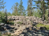
TheCaptain visited on 19th Jun 2005 - their rating: Cond: 5 Amb: 5 Access: 4 What a fantastic stone, and easily found near to the old D.5 road to the east of Plouarzel due to many signposts to it. This is the biggest standing menhir in Europe, if not the world, at nearly 10 metres tall, and has lost the top 2 metres after a lightning strike! It towers above all around, and standing as it does on top of a hill, it can be seen from 30 kilometres away.
The stone, which is not local and has been brought to this hilltop site from more than 2.5 kilometres away near the Aber Ildut estuary, has been beautifully shaped, and tapers both into the ground, and up to a point. On the two "thin" sides of the stone are round humps, about 20 cm in diameter about belly high above the ground.
This stone of course has many legends, such as treasure buried beneath it, going to drink at the ocean on the strike of 12:00 on Christmas night, and that newly wed couples should come here on their wedding night to rub the stone lumps for a good future and fertility. In fact, many wedding parties still come here to this day in order to perform this ritual.
It was a pity it was cold and late when I visited, and not good light for photographs. I feel I would like to stay here a while, it has a lovely atmosphere. Maybe I will come back tomorrow.
johnstone visited on 18th Jun 2003 - their rating: Cond: 5 Amb: 5 Access: 4
negus visited - their rating: Cond: 5 Amb: 5 Access: 5
neolithique02 DrewParsons Andy B ermine have visited here
Average ratings for this site from all visit loggers: Condition: 4.71 Ambience: 4.71 Access: 4.33
")
The stone, which is not local and has been brought to this hilltop site from more than 2.5 kilometres away near the Aber Ildut estuary, has been beautifully shaped, and tapers both into the ground, and up to a point.
On the two "thin" sides of the stone are round humps, about 20 cm in diameter about belly high above the ground.
This stone of course has many legends, such as treasure buried beneath it, going to drink at the ocean on the strike of 12:00 on Christmas night, and that newly wed couples should come here on their wedding night to rub the stone lumps for a good future and fertility. In fact, many wedding parties still come here to this day in order to perform this ritual.
It was a pity it was cold and late when I visited, and not good light for photographs.
What a fantastic stone, and easily found near to the old D.5 road to the east of Plouarzel due to many signposts to it.
The Journal of Antiquities also features a page for this standing stone - see their entry for Kerloas Menhir, Plouarzel, Finistere, Brittany, which includes directions for finding the stone, together with a description, photograph and old drawing, plus local folklore and their sources of information, including Briard, Jacques., The Megaliths of Brittany (Giseserot Edition), Rennes, 2001.
Also see the Wikipedia article for this menhir: Liste des sites mégalithiques du Finistère
Base Mérimée (Historic Monument)
You may be viewing yesterday's version of this page. To see the most up to date information please register for a free account.
")
")
")
")
")
")
")
")
")
")
")
")
")
")
")
")
")
")
")
")
")
")
")
")
These are just the first 25 photos of Kerloas Menhir. If you log in with a free user account you will be able to see our entire collection.
Do not use the above information on other web sites or publications without permission of the contributor.
Click here to see more info for this site
Nearby sites
Click here to view sites on an interactive map of the areaKey: Red: member's photo, Blue: 3rd party photo, Yellow: other image, Green: no photo - please go there and take one, Grey: site destroyed
Download sites to:
KML (Google Earth)
GPX (GPS waypoints)
CSV (Garmin/Navman)
CSV (Excel)
To unlock full downloads you need to sign up as a Contributory Member. Otherwise downloads are limited to 50 sites.
Turn off the page maps and other distractions
Nearby sites listing. In the following links * = Image available
3.4km NW 323° Afleurement à Cupules de Calétour Rock Art
4.9km WNW 290° Allee Couverte De Plouarzel* Chambered Tomb
5.4km S 171° Alignement de Kereven Stone Row / Alignment
6.6km NW 312° Menhir de Kerglonou* Standing Stone (Menhir)
8.1km W 279° Tumuli de l'ile Ségal* Barrow Cemetery
8.2km NNW 336° Kergadiou Menhirs* Standing Stones
8.2km NW 322° Mezdoun menhirs* Standing Stones
8.5km NW 323° Dolmen de Poulliot* Burial Chamber or Dolmen
8.7km N 357° Ruisseau De Plourin* Holy Well or Sacred Spring
9.1km NW 320° Dolmen de Lannidult* Burial Chamber or Dolmen
9.2km N 359° Tumulus du Bourg à Rubrat Huella Cairn
9.3km NW 321° Traonigou alignement de menhirs* Stone Row / Alignment
9.3km NW 321° Allee Couverte De Traonigou* Chambered Tomb
9.5km NNW 326° Saint-Denec Alignement de Menhirs* Stone Row / Alignment
9.5km SW 225° Allée Couverte de la Plage des Blancs Sablons Passage Grave
9.6km NNW 335° Stèle and menhir de la Chapelle de Larret* Standing Stones
9.6km NW 322° Menhir de Calès Standing Stone (Menhir)
9.7km NW 312° Île Melon menhirs* Standing Stones
9.7km NW 312° Île Melon grand menhir* Standing Stone (Menhir)
9.7km NW 312° Île Melon Dolmen* Burial Chamber or Dolmen
10.0km NW 322° Kerivoret Menhir* Standing Stone (Menhir)
10.0km SW 226° Allée Couverte de Kermorvan Passage Grave
10.0km NW 322° Kerivoret Dolmen* Burial Chamber or Dolmen
10.3km NNE 22° Menhir de Kervignen* Standing Stone (Menhir)
10.3km SW 228° Cromlech de Kermorvan* Standing Stones
View more nearby sites and additional images


 We would like to know more about this location. Please feel free to add a brief description and any relevant information in your own language.
 Wir möchten mehr über diese Stätte erfahren. Bitte zögern Sie nicht, eine kurze Beschreibung und relevante Informationen in Deutsch hinzuzufügen.
 Nous aimerions en savoir encore un peu sur les lieux. S'il vous plaît n'hesitez pas à ajouter une courte description et tous les renseignements pertinents dans votre propre langue.
 Quisieramos informarnos un poco más de las lugares. No dude en añadir una breve descripción y otros datos relevantes en su propio idioma.