 with our Megalithic Portal iPhone app")


<< Our Photo Pages >> Langbank Crannog (West) - Crannog in Scotland in Renfrewshire
Submitted by AstroGeologist on Sunday, 05 May 2019 Page Views: 1142
Iron Age and Later PrehistorySite Name: Langbank Crannog (West) Alternative Name: Langbank West Crannog, Clydeview CrannogCountry: Scotland
NOTE: This site is 0.278 km away from the location you searched for.
County: Renfrewshire Type: Crannog
Nearest Town: Port Glasgow Nearest Village: Langbank
Map Ref: NS3813073550
Latitude: 55.927694N Longitude: 4.592402W
Condition:
| 5 | Perfect |
| 4 | Almost Perfect |
| 3 | Reasonable but with some damage |
| 2 | Ruined but still recognisable as an ancient site |
| 1 | Pretty much destroyed, possibly visible as crop marks |
| 0 | No data. |
| -1 | Completely destroyed |
| 5 | Superb |
| 4 | Good |
| 3 | Ordinary |
| 2 | Not Good |
| 1 | Awful |
| 0 | No data. |
| 5 | Can be driven to, probably with disabled access |
| 4 | Short walk on a footpath |
| 3 | Requiring a bit more of a walk |
| 2 | A long walk |
| 1 | In the middle of nowhere, a nightmare to find |
| 0 | No data. |
| 5 | co-ordinates taken by GPS or official recorded co-ordinates |
| 4 | co-ordinates scaled from a detailed map |
| 3 | co-ordinates scaled from a bad map |
| 2 | co-ordinates of the nearest village |
| 1 | co-ordinates of the nearest town |
| 0 | no data |
Internal Links:
External Links:
I have visited· I would like to visit
AstroGeologist visited on 17th May 2019 - their rating: Cond: 2 Amb: 3 Access: 3 Langbank Crannog (West) :
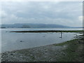
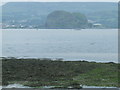
Today was the 2nd lowest tide of the year, so l wanted to get out and have a look at two of the Clyde Crannog's while the water levels were low.
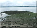
Only 20m from the Southern Bank of the River Clyde (After the building of the motorway) are the remains of a Crannog nearly 30m in diameter.
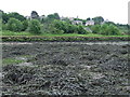
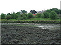
Not much of it remains these days, at least not above surface level. As I approached I could see what is now a large pile of boulders and stones, covered in seaweed.
You could easily see it's basic circular shape, by the boulders poking out through the seaweed. I had a good look around, trying to detect well-defined Ring of Piles described in 1972, but could only find one, on the Western arc of the Crannog. And I found that by accident when I was photographing a Crab, I saw a small bit of wood poking out through a bit of seaweed, when I removed it there was a solitary, small stumpy pile poking out of the mud. It was about 10cm tall.
I spent just under an hour at the Crannog, going around it many times, looking for more piles amongst the seaweed covered rocks. Near the edge of the Crannog, on the Western side I saw a bit of bit of wood, 1m long and wedged between some rocks, at first I got excited as I thought it might be a part of a log or beam with some relation to the Crannog, but when I picked it up I realised it couldn't have been 2,000 years old, the wood was too new, there was no darkening of the wood that is usually seen with ancient wood that has been buried under water.
I placed the small log in the position I found it, which was near the 10cm Pile I saw on the outer perimeter. A few metres North of the main pile of stones were 2 other bit of wood driven into the mud, 1 is about 30cm and the other about 90cm. I do not think these two bits of wood have anything to do with the Crannog but could be wrong.
Even though there isn't much there I didn't really want to leave. I stayed until I noticed the tide was starting to turn, so although the Sun had came back out I had to go.
This is 1 of 5 River Clyde Crannog's.
*Getting There ; From Langbank train station it is only 650m away (5 min walk)
If coming from Langbank Crannog (East) it is a 2.8km walk, taking about a half hour.
Come out the train station and turn left, walk West along Main Road (B789) for 425m and you'll soon come to a curve in the road on your right hand side. The Greenock Road (A8) should be on your right. Find a gap in the bushes and climb the fence.
You'll now have to cross the A8 dual carriageway, l was there when there wasn't much traffic so crossing was easy, but it can be busy at times. Once across make your way down the embankment and head West along the shoreline for 150m and your there.
 (PID:197513)")
The Crannog was roughly circular, and about 30m in diameter.
It is marked by a well-defined ring of piles, especially on the Western side.
Along the western margin of the site three small piles were found and further investigation revealed them to have square sections.
Contour survey of the site and the surrounding sandbanks showed a raised linear feature, and indicated that the whole site is situated on a raised mound.
"A.G.C. Hale" discovered a small amount of animal bones at the Crannog in 1997.
For more information : Canmore ID 42420
You may be viewing yesterday's version of this page. To see the most up to date information please register for a free account.
Do not use the above information on other web sites or publications without permission of the contributor.
Nearby Images from Geograph Britain and Ireland:
©2008(licence)
©2008(licence)
©2008(licence)
©2008(licence)
©2008(licence)
The above images may not be of the site on this page, they are loaded from Geograph.
Please Submit an Image of this site or go out and take one for us!
Click here to see more info for this site
Nearby sites
Key: Red: member's photo, Blue: 3rd party photo, Yellow: other image, Green: no photo - please go there and take one, Grey: site destroyed
Download sites to:
KML (Google Earth)
GPX (GPS waypoints)
CSV (Garmin/Navman)
CSV (Excel)
To unlock full downloads you need to sign up as a Contributory Member. Otherwise downloads are limited to 50 sites.
Turn off the page maps and other distractions
Nearby sites listing. In the following links * = Image available
2.0km ENE 62° Dumbarton Hilllfort* Hillfort (NS399744)
2.4km E 97° Langbank Crannog (East)* Crannog (NS4049773171)
3.3km WSW 245° High Castlehill Fort Hillfort (NS3505972281)
3.4km E 82° Dumbuck Crannog* Crannog (NS41577392)
3.7km S 188° Elphinstone Fort Hillfort (NS37506995)
4.1km WSW 243° Craigmarloch Fort Hillfort (NS34437185)
4.3km S 183° Lawfield Cairn* Cairn (NS37736922)
4.3km ENE 66° Dumbuie Dun* Hillfort (NS42187517)
4.4km W 269° Bogle Stane* Natural Stone / Erratic / Other Natural Feature (NS3370773634)
4.6km S 174° St Fillan's Holy Well (Kilallan)* Holy Well or Sacred Spring (NS38406899)
4.6km S 175° St Fillan's Seat (Kilallan)* Natural Stone / Erratic / Other Natural Feature (NS38396892)
4.7km S 186° Barlogan Cairn* Cairn (NS37426887)
4.7km WSW 237° Pennytersal Mounds Artificial Mound (NS3402071145)
4.8km E 101° Longhaugh Point Menhir* Standing Stone (Menhir) (NS4279972498)
4.9km NNW 337° Carman Hill cairn* Chambered Cairn (NS36357815)
4.9km WSW 251° Cunston Cist Cist (NS33407210)
5.1km SSE 150° Barochan Hillfort Hillfort (NS40566902)
5.4km ENE 77° Greenland 1 Rock Art (NS43447460)
5.4km E 79° Ardconnel Hill Fort* Hillfort (NS4348074400)
5.4km ENE 77° Greenland 2 Rock Art (NS43487462)
5.5km WSW 258° Devol Moor Ancient Village or Settlement (NS3269872597)
5.6km SSE 161° Sewn Dun Hillfort (NS39766816)
6.0km N 349° Carman Hill Fort* Hillfort (NS37207944)
6.2km WSW 245° Devol 1 Rock Art (NS324711)
6.4km NW 320° St Mahew’s Cross* Standing Stone (Menhir) (NS34207863)
View more nearby sites and additional images


 We would like to know more about this location. Please feel free to add a brief description and any relevant information in your own language.
 Wir möchten mehr über diese Stätte erfahren. Bitte zögern Sie nicht, eine kurze Beschreibung und relevante Informationen in Deutsch hinzuzufügen.
 Nous aimerions en savoir encore un peu sur les lieux. S'il vous plaît n'hesitez pas à ajouter une courte description et tous les renseignements pertinents dans votre propre langue.
 Quisieramos informarnos un poco más de las lugares. No dude en añadir una breve descripción y otros datos relevantes en su propio idioma.