


<< Our Photo Pages >> Pendine Bone Cave - Cave or Rock Shelter in Wales in Carmarthenshire
Submitted by pjk7009 on Thursday, 26 June 2014 Page Views: 6929
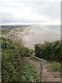
Natural PlacesSite Name: Pendine Bone Cave Alternative Name: Ogof PentywynCountry: Wales
NOTE: This site is 1.238 km away from the location you searched for.
County: Carmarthenshire Type: Cave or Rock Shelter
Map Ref: SN23200782
Latitude: 51.741118N Longitude: 4.562142W
Condition:
| 5 | Perfect |
| 4 | Almost Perfect |
| 3 | Reasonable but with some damage |
| 2 | Ruined but still recognisable as an ancient site |
| 1 | Pretty much destroyed, possibly visible as crop marks |
| 0 | No data. |
| -1 | Completely destroyed |
| 5 | Superb |
| 4 | Good |
| 3 | Ordinary |
| 2 | Not Good |
| 1 | Awful |
| 0 | No data. |
| 5 | Can be driven to, probably with disabled access |
| 4 | Short walk on a footpath |
| 3 | Requiring a bit more of a walk |
| 2 | A long walk |
| 1 | In the middle of nowhere, a nightmare to find |
| 0 | No data. |
| 5 | co-ordinates taken by GPS or official recorded co-ordinates |
| 4 | co-ordinates scaled from a detailed map |
| 3 | co-ordinates scaled from a bad map |
| 2 | co-ordinates of the nearest village |
| 1 | co-ordinates of the nearest town |
| 0 | no data |
Internal Links:
External Links:
")
Cambrian Cave Registry Entry Number 1007
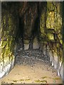
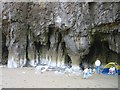
pjk7009 writes: I have found some unverified potential rock art in the middle chamber of Pendine Bone Cave. The carvings are on the arch looking out to sea and comprise of four parallel lines cut in to the rock. They are strikingly similar to the carvings discussed in this article which suggest that previously overlooked patterns in the cave art of southern France and Spain suggest man might have learned written communication 25,000 years earlier than we thought.
Note: A possible rock art discovery? Based on reports of similar patterns found in caves in France and Spain
You may be viewing yesterday's version of this page. To see the most up to date information please register for a free account.
")
")
Do not use the above information on other web sites or publications without permission of the contributor.
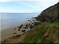
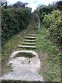
Nearby Images from Geograph Britain and Ireland:
©2013(licence)
©2023(licence)
©2023(licence)
©2013(licence)
©2023(licence)
The above images may not be of the site on this page, they are loaded from Geograph.
Please Submit an Image of this site or go out and take one for us!
Click here to see more info for this site
Nearby sites
Key: Red: member's photo, Blue: 3rd party photo, Yellow: other image, Green: no photo - please go there and take one, Grey: site destroyed
Download sites to:
KML (Google Earth)
GPX (GPS waypoints)
CSV (Garmin/Navman)
CSV (Excel)
To unlock full downloads you need to sign up as a Contributory Member. Otherwise downloads are limited to 50 sites.
Turn off the page maps and other distractions
Nearby sites listing. In the following links * = Image available
455m WSW 239° Gilman Point fort* Promontory Fort / Cliff Castle (SN228076)
1.1km WSW 251° Morfa Bychan* Chambered Cairn (SN22130749)
1.2km WSW 238° Forest Chamber* Burial Chamber or Dolmen (SN22180724)
2.4km WNW 301° Marros settlement* Ancient Village or Settlement (SN212091)
3.7km W 266° Top Castle, Eglwyscummin* Hillfort (SN19460772)
4.7km NE 51° Holy Stones Llansadurnan Sculptured Stone
4.7km WNW 303° Parc-y-Twmp* Round Barrow(s) (SN19341051)
5.1km NNE 13° Castell Pen-Y-Coed Hillfort (SN24531278)
5.4km ENE 74° Coygan Cave Cave or Rock Shelter (SN28480913)
6.1km NE 54° Llandawke Inscribed Stone* Early Christian Sculptured Stone (SN2827111214)
6.5km N 11° Vaynor Farm Henge* Henge (SN24701417)
7.1km NW 307° Crug Swllt* Round Barrow(s) (SN17711231)
7.1km NNE 17° Cross Stones, Llanddowror* Early Christian Sculptured Stone (SN25531458)
7.2km W 260° Amroth Submerged Forest Not Known (by us) (SN16070678)
7.2km W 260° Amroth Submerged Forest Not Known (by us) (SN16070678)
7.4km NNE 17° Llanddowror Standing stone* Standing Stone (Menhir) (SN25621487)
7.7km ENE 63° St Martin's Church (Laugharne)* Ancient Cross (SN302110)
8.3km WNW 294° Newhouse Barrows* Barrow Cemetery (SN15711141)
8.5km WNW 283° Longstone Camp* Hillfort (SN14990996)
8.7km W 278° The Longstone (Pembrokeshire)* Standing Stone (Menhir) (SN146094)
8.8km WNW 293° Belle Vue* Standing Stone (Menhir) (SN15211146)
9.1km NNE 26° Eithin Fach Mound* Round Barrow(s) (SN27521589)
10.1km NE 50° Gors Llangynog* Standing Stones (SN312140)
10.3km NE 51° Meini Llwydion, Llangynog* Standing Stones (SN3145513969)
10.3km NE 45° Pont Ddu* Stone Row / Alignment (SN30791484)
View more nearby sites and additional images


 We would like to know more about this location. Please feel free to add a brief description and any relevant information in your own language.
 Wir möchten mehr über diese Stätte erfahren. Bitte zögern Sie nicht, eine kurze Beschreibung und relevante Informationen in Deutsch hinzuzufügen.
 Nous aimerions en savoir encore un peu sur les lieux. S'il vous plaît n'hesitez pas à ajouter une courte description et tous les renseignements pertinents dans votre propre langue.
 Quisieramos informarnos un poco más de las lugares. No dude en añadir una breve descripción y otros datos relevantes en su propio idioma.