


<< Our Photo Pages >> Druidale - Ancient Village or Settlement in Channel Islands and Isle of Man in Isle of Man
Submitted by Bladup on Friday, 24 May 2013 Page Views: 6825
Multi-periodSite Name: DruidaleCountry: Channel Islands and Isle of Man
NOTE: This site is 3.475 km away from the location you searched for.
Island: Isle of Man Type: Ancient Village or Settlement
Map Ref: SC356878
Latitude: 54.259374N Longitude: 4.525426W
Condition:
| 5 | Perfect |
| 4 | Almost Perfect |
| 3 | Reasonable but with some damage |
| 2 | Ruined but still recognisable as an ancient site |
| 1 | Pretty much destroyed, possibly visible as crop marks |
| 0 | No data. |
| -1 | Completely destroyed |
| 5 | Superb |
| 4 | Good |
| 3 | Ordinary |
| 2 | Not Good |
| 1 | Awful |
| 0 | No data. |
| 5 | Can be driven to, probably with disabled access |
| 4 | Short walk on a footpath |
| 3 | Requiring a bit more of a walk |
| 2 | A long walk |
| 1 | In the middle of nowhere, a nightmare to find |
| 0 | No data. |
| 5 | co-ordinates taken by GPS or official recorded co-ordinates |
| 4 | co-ordinates scaled from a detailed map |
| 3 | co-ordinates scaled from a bad map |
| 2 | co-ordinates of the nearest village |
| 1 | co-ordinates of the nearest town |
| 0 | no data |
Internal Links:
External Links:
")
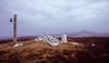
A group of hut circles at the wonderful Druidale, there's cairns a few yards to the East as well.
You may be viewing yesterday's version of this page. To see the most up to date information please register for a free account.
")
")
Do not use the above information on other web sites or publications without permission of the contributor.
Nearby Images from Flickr
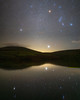
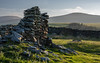
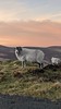

The above images may not be of the site on this page, but were taken nearby. They are loaded from Flickr so please click on them for image credits.
Click here to see more info for this site
Nearby sites
Click here to view sites on an interactive map of the areaKey: Red: member's photo, Blue: 3rd party photo, Yellow: other image, Green: no photo - please go there and take one, Grey: site destroyed
Download sites to:
KML (Google Earth)
GPX (GPS waypoints)
CSV (Garmin/Navman)
CSV (Excel)
To unlock full downloads you need to sign up as a Contributory Member. Otherwise downloads are limited to 50 sites.
Turn off the page maps and other distractions
Nearby sites listing. In the following links * = Image available
4.7km WNW 289° Cronk Guckley mounds* Round Barrow(s) (SC31238945)
4.8km NNE 22° Oaie ny Foawr (Sulby) Round Barrow(s) (SC376922)
5.3km WNW 282° Michael Standing Stone and rock art* Standing Stone (Menhir) (SC30468908)
5.9km NNW 337° Magher ny Clogh Mooar* Standing Stone (Menhir) (SC335933)
6.6km NNW 328° Orrisdale* Cairn (SC323935)
6.7km W 265° Corvalley Cairn* Cairn (SC28938747)
6.9km W 265° Ballakaighen* Ancient Village or Settlement (SC287874)
7.2km NNE 28° Cronk Sumark* Vitrified Fort (SC392941)
8.0km SSW 195° Keill Vreeshey (Crosby) Sculptured Stone (SC332802)
8.1km NNW 347° Runic Cross (Ballaugh Old Church)* Ancient Cross
8.5km SSW 205° St Trinian's Chapel (Marown) Ancient Cross (SC31778023)
8.5km WSW 248° Meir ny Foawr (Knocksharry) Stone Circle (SC27588495)
8.5km ENE 58° Glen Auldyn Cist* Cist (SC4392)
8.6km WSW 248° Staarvey Farm Cist burial Cist
8.9km ESE 110° King Orry's Grave* Chambered Tomb (SC43898439)
9.2km SW 218° Chibbyr Roney* Holy Well or Sacred Spring (SC296808)
9.3km WSW 240° Giant's Grave (Isle of Man)* Chambered Tomb (SC27438340)
9.3km S 185° White Lady of Ballafreer* Standing Stone (Menhir)
9.5km N 349° Ballateare Viking burial mound Round Barrow(s)
9.7km SE 129° Cloven Stones* Chambered Tomb (SC42928141)
9.7km SW 230° Ballaharra stones Burial Chamber or Dolmen
9.7km SSW 199° Marown Old Church Holy Well or Sacred Spring (SC3215378674)
9.8km SW 231° Giant's grave (St John's)* Cist (SC27758193)
9.8km E 100° Spiral stone (Ballaragh)* Rock Art (SC4520085670)
10.4km SSE 161° White Lady Stone* Standing Stone (Menhir) (SC38597783)
View more nearby sites and additional images


 We would like to know more about this location. Please feel free to add a brief description and any relevant information in your own language.
 Wir möchten mehr über diese Stätte erfahren. Bitte zögern Sie nicht, eine kurze Beschreibung und relevante Informationen in Deutsch hinzuzufügen.
 Nous aimerions en savoir encore un peu sur les lieux. S'il vous plaît n'hesitez pas à ajouter une courte description et tous les renseignements pertinents dans votre propre langue.
 Quisieramos informarnos un poco más de las lugares. No dude en añadir una breve descripción y otros datos relevantes en su propio idioma.