


<< Our Photo Pages >> Cueva el Pindal - Cave or Rock Shelter in Spain in Asturias
Submitted by coldrum on Friday, 10 July 2009 Page Views: 7565
Natural PlacesSite Name: Cueva el PindalCountry: Spain
NOTE: This site is 2.799 km away from the location you searched for.
Region: Asturias Type: Cave or Rock Shelter
Nearest Town: Unqeraa Nearest Village: Pimiango
Latitude: 43.397655N Longitude: 4.532897W
Condition:
| 5 | Perfect |
| 4 | Almost Perfect |
| 3 | Reasonable but with some damage |
| 2 | Ruined but still recognisable as an ancient site |
| 1 | Pretty much destroyed, possibly visible as crop marks |
| 0 | No data. |
| -1 | Completely destroyed |
| 5 | Superb |
| 4 | Good |
| 3 | Ordinary |
| 2 | Not Good |
| 1 | Awful |
| 0 | No data. |
| 5 | Can be driven to, probably with disabled access |
| 4 | Short walk on a footpath |
| 3 | Requiring a bit more of a walk |
| 2 | A long walk |
| 1 | In the middle of nowhere, a nightmare to find |
| 0 | No data. |
| 5 | co-ordinates taken by GPS or official recorded co-ordinates |
| 4 | co-ordinates scaled from a detailed map |
| 3 | co-ordinates scaled from a bad map |
| 2 | co-ordinates of the nearest village |
| 1 | co-ordinates of the nearest town |
| 0 | no data |
Internal Links:
External Links:
I have visited· I would like to visit
Kuba would like to visit
")
Cave with rock art.
vivirasturias
You may be viewing yesterday's version of this page. To see the most up to date information please register for a free account.
")
")
Do not use the above information on other web sites or publications without permission of the contributor.
Nearby Images from Flickr
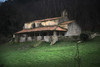
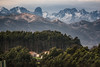


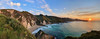
The above images may not be of the site on this page, but were taken nearby. They are loaded from Flickr so please click on them for image credits.
Click here to see more info for this site
Nearby sites
Click here to view sites on an interactive map of the areaKey: Red: member's photo, Blue: 3rd party photo, Yellow: other image, Green: no photo - please go there and take one, Grey: site destroyed
Download sites to:
KML (Google Earth)
GPX (GPS waypoints)
CSV (Garmin/Navman)
CSV (Excel)
To unlock full downloads you need to sign up as a Contributory Member. Otherwise downloads are limited to 50 sites.
Turn off the page maps and other distractions
Nearby sites listing. In the following links * = Image available
3.1km WSW 251° Cueva de Mazaculos Cave or Rock Shelter
7.0km ESE 109° Cierrón Round Barrow(s)
7.8km S 189° Cueva de la Loja* Cave or Rock Shelter
11.2km W 271° Cueva de Cordoveganes Cave or Rock Shelter
11.3km ESE 116° Cotero de la Mina* Burial Chamber or Dolmen
12.1km SW 234° Cueva de Llonín* Cave or Rock Shelter
12.4km SW 226° Cueva de Subores Cave or Rock Shelter
12.5km ESE 116° La Raíz tumuli* Round Barrow(s)
12.6km ESE 115° La Raíz 3 Round Barrow(s)
12.7km W 268° Peña Tú* Rock Outcrop
12.7km W 268° Villa Romana de Veranes Ancient Village or Settlement
14.1km SSW 194° Llaves Menhir* Standing Stone (Menhir)
14.1km SSW 194° Llaves dolmen* Burial Chamber or Dolmen
14.5km WSW 241° Cueva de Coímbre* Cave or Rock Shelter
17.3km S 173° Cires 1 Round Barrow(s)
17.6km SSE 156° Cuesta Nabea 3 Round Barrow(s)
17.7km SSE 155° Cuesta Nabea 2 Round Barrow(s)
17.7km S 174° Cires 3 Round Barrow(s)
17.8km SSE 155° Cuesta Nabea 1 Round Barrow(s)
18.0km WSW 240° Cueva de Traúno Cave or Rock Shelter
19.2km W 280° La Punta la Torre* Castro or Chafurdão
19.5km W 271° Cueva de La Herrería Cave or Rock Shelter
19.7km S 175° Cires 13 Round Barrow(s)
19.7km W 273° Cueva El Covarón Cave or Rock Shelter
19.8km S 175° Cires 14 Round Barrow(s)
View more nearby sites and additional images


 We would like to know more about this location. Please feel free to add a brief description and any relevant information in your own language.
 Wir möchten mehr über diese Stätte erfahren. Bitte zögern Sie nicht, eine kurze Beschreibung und relevante Informationen in Deutsch hinzuzufügen.
 Nous aimerions en savoir encore un peu sur les lieux. S'il vous plaît n'hesitez pas à ajouter une courte description et tous les renseignements pertinents dans votre propre langue.
 Quisieramos informarnos un poco más de las lugares. No dude en añadir una breve descripción y otros datos relevantes en su propio idioma.