


<< Our Photo Pages >> Ichthus Stone - Early Christian Sculptured Stone in Wales in Anglesey
Submitted by guile on Saturday, 19 June 2010 Page Views: 8888
Early Medieval (Dark Age)Site Name: Ichthus Stone Alternative Name: Ichtheus StoneCountry: Wales
NOTE: This site is 1.364 km away from the location you searched for.
County: Anglesey Type: Early Christian Sculptured Stone
Nearest Town: Amlwch Nearest Village: Cemaes
Map Ref: SH376946
Latitude: 53.423120N Longitude: 4.445461W
Condition:
| 5 | Perfect |
| 4 | Almost Perfect |
| 3 | Reasonable but with some damage |
| 2 | Ruined but still recognisable as an ancient site |
| 1 | Pretty much destroyed, possibly visible as crop marks |
| 0 | No data. |
| -1 | Completely destroyed |
| 5 | Superb |
| 4 | Good |
| 3 | Ordinary |
| 2 | Not Good |
| 1 | Awful |
| 0 | No data. |
| 5 | Can be driven to, probably with disabled access |
| 4 | Short walk on a footpath |
| 3 | Requiring a bit more of a walk |
| 2 | A long walk |
| 1 | In the middle of nowhere, a nightmare to find |
| 0 | No data. |
| 5 | co-ordinates taken by GPS or official recorded co-ordinates |
| 4 | co-ordinates scaled from a detailed map |
| 3 | co-ordinates scaled from a bad map |
| 2 | co-ordinates of the nearest village |
| 1 | co-ordinates of the nearest town |
| 0 | no data |
Internal Links:
External Links:
I have visited· I would like to visit
jess lichen would like to visit
cactus_chris visited on 16th May 2019 - their rating: Cond: 4 Amb: 5 Access: 5 This was a very nice visit to a the chuch when walking the Anglesey Coastal Path. A gentleman passed me on the lane and offered me a lift to the chuch (I declined as that would have been "cheating"). We had a nice chat in the church and I saw this stone too. The chuch is very nice inside and decorated in an Islamic Style.
guile have visited here
")
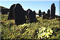
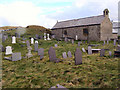
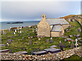
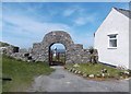
The Ichthus Stone is to be found against the west wall inside the church of Llanbadrig near Cemaes Bay, on the north coast of Anglesey, North Wales.
The stone was hidden beneath the plaster of the church for many years until in 1884 renovations exposed the stone. It carries the early Christian symbols of the fish and the palm tree, the latter signifying Jerusalem. Similar stones have been found in the catacombs in Rome, and for some time it was thought the stone was of a foreign origin.
But the inscriptions are probably representative of the 9th to the 11th Century gravestones of which there are several to be found in Anglesey.
Following investigation by the Department of Geology at Leicester University it is now accepted as being an Anglesey stone that has been used for more than one purpose. It would initially have been used as a standing stone (a similar stone believed to be some 4500 years old was found in the middle of a large field near Llanerchymedd), before early christians claimed the stone for themselves around the 10th Century.
On the bench just before the churchyard the Dalai Lama claimed to have found the most peaceful spot on earth.
You may be viewing yesterday's version of this page. To see the most up to date information please register for a free account.
")
")
Do not use the above information on other web sites or publications without permission of the contributor.
Nearby Images from Geograph Britain and Ireland:
©2006(licence)

©2008(licence)
©2010(licence)
©2010(licence)
©2014(licence)
The above images may not be of the site on this page, they are loaded from Geograph.
Please Submit an Image of this site or go out and take one for us!
Click here to see more info for this site
Nearby sites
Key: Red: member's photo, Blue: 3rd party photo, Yellow: other image, Green: no photo - please go there and take one, Grey: site destroyed
Download sites to:
KML (Google Earth)
GPX (GPS waypoints)
CSV (Garmin/Navman)
CSV (Excel)
To unlock full downloads you need to sign up as a Contributory Member. Otherwise downloads are limited to 50 sites.
Turn off the page maps and other distractions
Nearby sites listing. In the following links * = Image available
1.6km ENE 70° Dinas Gynfor* Hillfort (SH391951)
3.0km S 190° Llanfechell 2* Standing Stone (Menhir) (SH3699291640)
3.0km SSW 209° Foel Fawr (Anglesey)* Chambered Tomb (SH3604692003)
3.1km SSW 200° Llanfechell 1* Standing Stones (SH3639791688)
4.1km SW 219° Caerdegog Uchaf* Modern Stone Circle etc (SH349915)
4.3km ESE 112° Werthyr* Standing Stone (Menhir) (SH4152292868)
5.3km SE 144° Bodewryd* Standing Stone (Menhir) (SH406902)
5.5km SSE 158° Maen y Goges* Natural Stone / Erratic / Other Natural Feature (SH39518948)
5.8km SW 225° Pen yr Orsedd 2* Standing Stone (Menhir) (SH33399062)
6.0km SW 223° Pen Yr Orsedd* Standing Stone (Menhir) (SH3334190391)
7.5km S 177° St Pabo's Church Memorial Stone* Early Christian Sculptured Stone (SH378871)
8.0km ESE 119° Parys Mountain* Ancient Mine, Quarry or other Industry (SH445905)
8.9km WSW 249° Ynys-y-Fydlyn* Promontory Fort / Cliff Castle (SH29189175)
8.9km S 183° Bod Deiniol* Standing Stone (Menhir) (SH3683285739)
8.9km E 96° Porth Newydd* Natural Stone / Erratic / Other Natural Feature (SH46449341)
9.0km WSW 242° Rhoscryman Cairn* Cairn (SH29479072)
9.0km E 96° St Eilian's Well* Holy Well or Sacred Spring (SH46569329)
9.5km E 98° St Eilian (Llaneilian)* Ancient Cross (SH46949288)
9.7km S 187° Bedd Branwen* Ring Cairn (SH3611184978)
10.0km SSW 212° Soar Stone* Standing Stone (Menhir) (SH3192286327)
10.1km SSW 199° Llynnon Mill and Iron Age Settlement* Museum (SH340852)
10.3km SE 146° Bryn Dyfrydog* Standing Stone (Menhir) (SH431859)
10.5km SE 146° Maen Chwyf* Natural Stone / Erratic / Other Natural Feature (SH43268574)
11.0km S 185° New Church* Standing Stone (Menhir) (SH363837)
11.3km SSE 151° Bedd y Foel* Burial Chamber or Dolmen (SH42698444)
View more nearby sites and additional images


 We would like to know more about this location. Please feel free to add a brief description and any relevant information in your own language.
 Wir möchten mehr über diese Stätte erfahren. Bitte zögern Sie nicht, eine kurze Beschreibung und relevante Informationen in Deutsch hinzuzufügen.
 Nous aimerions en savoir encore un peu sur les lieux. S'il vous plaît n'hesitez pas à ajouter une courte description et tous les renseignements pertinents dans votre propre langue.
 Quisieramos informarnos un poco más de las lugares. No dude en añadir una breve descripción y otros datos relevantes en su propio idioma.