


<< Text Pages >> Duncarnock Hillfort - Hillfort in Scotland in Renfrewshire
Submitted by AstroGeologist on Wednesday, 08 May 2019 Page Views: 2134
Iron Age and Later PrehistorySite Name: Duncarnock Hillfort Alternative Name: Dun Carnock, Craig Of CarnockCountry: Scotland
NOTE: This site is 2.665 km away from the location you searched for.
County: Renfrewshire Type: Hillfort
Nearest Town: Barrhead Nearest Village: Neilston
Map Ref: NS50105590
Latitude: 55.773130N Longitude: 4.391256W
Condition:
| 5 | Perfect |
| 4 | Almost Perfect |
| 3 | Reasonable but with some damage |
| 2 | Ruined but still recognisable as an ancient site |
| 1 | Pretty much destroyed, possibly visible as crop marks |
| 0 | No data. |
| -1 | Completely destroyed |
| 5 | Superb |
| 4 | Good |
| 3 | Ordinary |
| 2 | Not Good |
| 1 | Awful |
| 0 | No data. |
| 5 | Can be driven to, probably with disabled access |
| 4 | Short walk on a footpath |
| 3 | Requiring a bit more of a walk |
| 2 | A long walk |
| 1 | In the middle of nowhere, a nightmare to find |
| 0 | No data. |
| 5 | co-ordinates taken by GPS or official recorded co-ordinates |
| 4 | co-ordinates scaled from a detailed map |
| 3 | co-ordinates scaled from a bad map |
| 2 | co-ordinates of the nearest village |
| 1 | co-ordinates of the nearest town |
| 0 | no data |
Internal Links:
External Links:
Hillfort in Renfrewshire
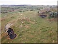
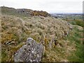
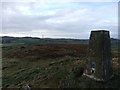
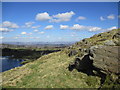
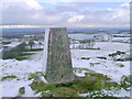
Duncarnock Hillfort is located on top of a steep sided Volcanic Plug, which rises abruptly from the shore of Glanderston Dam in the Renfrewshire Hills.
Situated 200m above sea level, it has an irregular polygon shape to it, with an approx NE~SW alignment. The summit consists of a broad ridge at the North end, where a rocky knoll rises rather suddenly to a height of 204m. With an overall size of 1.6ha, the Fort dimensions are 190m x 100m, while the summit of the knoll is about 33m x 25m.
The Fort comprised a wall, originally between 3m~4m thick, with a partial inner defence built around the knoll, along with wide terrace fronts the entire length of the Southern Rampart. Traces of rig-and-furrow cultivation are also visible, while roughly in the centre of the Fort there are the footings of a small rectangular building, with a second overlying the Fort wall on the SE. Most of these walls are now a Heather-grown spread of rubble.
In 1958 "F.Newall" found a piece of pre-Roman pottery and a fragment of worked Shale near the NE corner of the Fort.
For more information : Canmore ID 43882
You may be viewing yesterday's version of this page. To see the most up to date information please register for a free account.
Do not use the above information on other web sites or publications without permission of the contributor.
Nearby Images from Geograph Britain and Ireland:
©2021(licence)
©2021(licence)
©2012(licence)
©2020(licence)
©2009(licence)
The above images may not be of the site on this page, they are loaded from Geograph.
Please Submit an Image of this site or go out and take one for us!
Click here to see more info for this site
Nearby sites
Key: Red: member's photo, Blue: 3rd party photo, Yellow: other image, Green: no photo - please go there and take one, Grey: site destroyed
Download sites to:
KML (Google Earth)
GPX (GPS waypoints)
CSV (Garmin/Navman)
CSV (Excel)
To unlock full downloads you need to sign up as a Contributory Member. Otherwise downloads are limited to 50 sites.
Turn off the page maps and other distractions
Nearby sites listing. In the following links * = Image available
3.5km SW 221° Covenanter's Stone* Stone Circle (NS47735333)
4.2km SW 223° Moyne Moor* Cairn (NS471529)
5.0km ENE 67° Rouken Glen Park* Rock Art (NS54795771)
6.3km NE 37° Boydstone Road (Eastwood) Standing Stone (Menhir) (NS541608)
6.4km NW 311° Gleniffer Braes Menhirs* Standing Stones (NS45356026)
6.9km SE 146° Ballageich Hill* Cairn (NS53745005)
7.3km NE 36° Pollok House Barrow* Round Barrow(s) (NS54606164)
7.8km SE 138° West Revoch Stone Row / Alignment (NS55104995)
8.2km NNW 347° Barochan Cross* Ancient Cross (NS48556395)
8.7km NW 310° High Craigenfeoch Rock Art* Rock Art (NS43616168)
8.7km NW 307° Craigston Wood Menhir* Standing Stone (Menhir) (NS4332961360)
9.4km WNW 286° Walls Hill Fort Hillfort (NS4117058800)
11.1km WSW 237° Thougritstane* Natural Stone / Erratic / Other Natural Feature (NS40575024)
11.3km NNE 26° The Govan Stones* Museum (NS55346590)
11.5km W 265° Cuff Hill* Chambered Cairn (NS386552)
12.0km NW 308° Barr Hill Fort Hillfort (NS40946365)
12.2km W 264° Four Stones (North Ayrshire) Stone Circle (NS379550)
12.3km NNE 31° Kelvingrove Museum and Art Gallery* Museum (NS5676166302)
12.5km NE 43° St Thenew's Well (Glasgow) Holy Well or Sacred Spring (NS589648)
12.7km NNE 30° Hunterian Museum* Museum (NS56906667)
12.8km NE 48° Arns Well (Glasgow) Holy Well or Sacred Spring (NS59966406)
12.9km NE 44° Stock Well (Glasgow) Holy Well or Sacred Spring (NS594649)
13.0km E 87° Law Knowe* Cairn (NS63175613)
13.3km NE 46° St Mungo's Well (Dovehill) Holy Well or Sacred Spring (NS5998464788)
13.8km WNW 291° Clochodrick Stone* Natural Stone / Erratic / Other Natural Feature (NS37366127)
View more nearby sites and additional images


 We would like to know more about this location. Please feel free to add a brief description and any relevant information in your own language.
 Wir möchten mehr über diese Stätte erfahren. Bitte zögern Sie nicht, eine kurze Beschreibung und relevante Informationen in Deutsch hinzuzufügen.
 Nous aimerions en savoir encore un peu sur les lieux. S'il vous plaît n'hesitez pas à ajouter une courte description et tous les renseignements pertinents dans votre propre langue.
 Quisieramos informarnos un poco más de las lugares. No dude en añadir una breve descripción y otros datos relevantes en su propio idioma.