Featured: Hare and Tabor T Shirts for discerning antiquarians

Hare and Tabor T Shirts for discerning antiquarians

Avebury Archaeology Map

Avebury Archaeology Map

Who's Online

There are currently, 313 guests and 2 members online.

You are a guest. To join in, please register for free by clicking here

Sponsors

<< Other Photo Pages >> Tarradale - Chambered Tomb in Scotland in Highlands

Submitted by Andy B on Sunday, 27 August 2017  Page Views: 7054

Neolithic and Bronze AgeSite Name: Tarradale
Country: Scotland
NOTE: This site is 1.384 km away from the location you searched for.

County: Highlands Type: Chambered Tomb
Nearest Town: Dingwall  Nearest Village: Muir of Ord
Map Ref: NH549497  Landranger Map Number: 26
Latitude: 57.514154N  Longitude: 4.423949W
Condition:
5Perfect
4Almost Perfect
3Reasonable but with some damage
2Ruined but still recognisable as an ancient site
1Pretty much destroyed, possibly visible as crop marks
0No data.
-1Completely destroyed
3 Ambience:
5Superb
4Good
3Ordinary
2Not Good
1Awful
0No data.
3 Access:
5Can be driven to, probably with disabled access
4Short walk on a footpath
3Requiring a bit more of a walk
2A long walk
1In the middle of nowhere, a nightmare to find
0No data.
no data Accuracy:
5co-ordinates taken by GPS or official recorded co-ordinates
4co-ordinates scaled from a detailed map
3co-ordinates scaled from a bad map
2co-ordinates of the nearest village
1co-ordinates of the nearest town
0no data
3

Internal Links:
External Links:

Tarradale
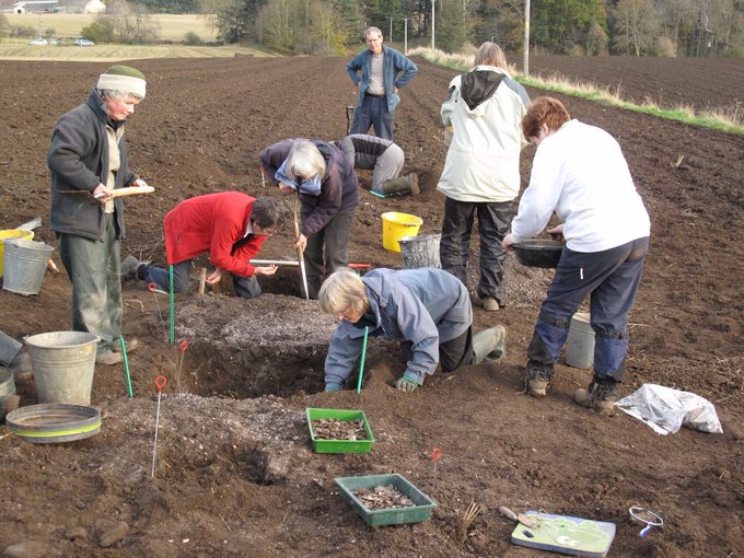
Tarradale submitted by dodomad : Tarradale Through Time‏ community archaeology project, digging from 23 Sept 2017 at Tarradale Photo Credit: Tarradale Through Time‏ (Vote or comment on this photo)
Chambered Tomb in Highland

Tarradale Through Time‏ community archaeology project, digging from 23 Sept 2017 at Tarradale. Working on either the Castle Site or the Promontory Fort followed by the Shell Middens.

Page originally by Vicky Morgan

Note: Tarradale Through Time‏ community archaeology project, digging from 23 Sept 2017 at Tarradale, near Muir of Ord, Inverness. More details in the comments
You may be viewing yesterday's version of this page. To see the most up to date information please register for a free account.


Do not use the above information on other web sites or publications without permission of the contributor.

Nearby Images from Geograph Britain and Ireland:
NH5449 : Tarradale Chambered Cairn by valenta
by valenta
©2018(licence)
NH5449 : Tarradale Chambered Cairn by valenta
by valenta
©2018(licence)
NH5449 : Tarradale Chambered Cairn by valenta
by valenta
©2018(licence)
NH5449 : The A832 near Hilton by Douglas Nelson
by Douglas Nelson
©2021(licence)
NH5449 : A832 from Muir of Ord to Tore by Steven Brown
by Steven Brown
©2010(licence)

The above images may not be of the site on this page, they are loaded from Geograph.
Please Submit an Image of this site or go out and take one for us!


Click here to see more info for this site

Nearby sites

Click here to view sites on an interactive OS map

Key: Red: member's photo, Blue: 3rd party photo, Yellow: other image, Green: no photo - please go there and take one, Grey: site destroyed

Download sites to:
KML (Google Earth)
GPX (GPS waypoints)
CSV (Garmin/Navman)
CSV (Excel)

To unlock full downloads you need to sign up as a Contributory Member. Otherwise downloads are limited to 50 sites.


Turn off the page maps and other distractions

Nearby sites listing. In the following links * = Image available
 2.2km W 268° Muir of Ord Henge* Henge (NH527497)
 2.3km SW 228° Windhill* Standing Stones (NH531482)
 2.4km NNW 335° Balvaird Chambered Cairn (NH53945193)
 2.7km N 352° Muir of Conan Chambered Cairn (NH546524)
 2.8km NE 47° Kilcoy South* Chambered Tomb (NH570515)
 2.9km N 360° Muir of Allangrange* Chambered Cairn (NH55005259)
 2.9km NE 44° Kilcoy North Chambered Tomb (NH570517)
 3.0km NNE 19° Cairnside Chambered Tomb (NH560525)
 3.1km NNW 343° Bishop Kinkell Chambered Cairn (NH541527)
 3.1km NNE 32° Carn Urnan* Stone Circle (NH5666252289)
 3.6km NE 50° Mains of Kilcoy NW* Cairn (NH57725191)
 3.6km NE 51° Mains of Kilcoy SE* Cairn (NH57765186)
 3.7km NE 49° Carn Glas* Chambered Cairn (NH578520)
 5.4km N 351° Conon Bridge* Henge (NH54295507)
 6.1km SSE 169° Giant's Grave (Highlands) Chambered Cairn (NH55904369)
 6.1km S 175° Balblair Class I Pictish Symbol Stone (NH55184357)
 7.0km SW 220° Ballblair Wood Chambered Cairn (NH502445)
 7.0km NNW 342° Ussie Chambered Cairn* Chambered Cairn (NH530565)
 7.1km NW 319° Brahan Wood* Chambered Cairn (NH504552)
 7.5km ENE 65° The Temple (Tore)* Chambered Tomb (NH6179952610)
 7.6km NNE 19° Mulchaich* Cairn (NH57665679)
 7.7km S 184° Castle Spynie Broch or Nuraghe (NH54144204)
 8.3km SSW 203° Belladrum Chambered Cairn* Chambered Cairn (NH5141742120)
 8.7km SSW 200° Belladrum South Chambered Tomb (NH5161041578)
 9.1km SSW 199° Meg's Stone* Standing Stone (Menhir) (NH5164541196)
View more nearby sites and additional images

<< Summstein Hammerstein

Santa Elena (Brazil) >>

Please add your thoughts on this site

Build your own Stonehenge! (Model)

Build your own Stonehenge! (Model)

Sponsors

Auto-Translation (Google)

Translate from English into:

"Tarradale" | Login/Create an Account | 3 News and Comments
  
Go back to top of page    Comments are owned by the poster. We aren't responsible for their content.
Tarradale Through Time Project - Excavations September-October 2017 by Andy B on Sunday, 27 August 2017
(User Info | Send a Message)
Tarradale Through Time Project. Lead Eric Grant, NOSAS Committee liaison Jonie Guest

For some years NOSAS members have been field walking after the fields are ploughed in winter. Important sites dating from Mesolithic to post-medieval have been identified as well as some fascinating finds of worked flint, pottery and coins. Field walking normally takes place each Sunday during the winter months. Please contact Eric if you are interested.

The Tarradale Through Time Project has now been awarded £69,300 of Heritage Lottery Funding to undertake a programme of archaeological excavations and investigations. See the Tarradale Through Time page for further details. Further information is also available on our blog.

https://nosasblog.wordpress.com/2016/01/06/tarradale-archaeological-project-findings-to-date/

Dear All

I am delighted to let you all know that Tarradale Through Time has been successful in its HLF funding bid. This means that we will be starting the first phase of the project this September. We will be working on either the Castle Site or the Promontory Fort from Saturday 23rd September until Saturday 30th September inclusive followed by the Shell Middens from Saturday 30th September until Friday 6th October inclusive.

The funding from HLF is very much on the understanding that Tarradale through time is a community archaeological project and we need to involve the local community (that can be defined as wide as you want and includes non-NOSAS members) in our excavation and post excavation work. We are looking for 2 kinds of volunteers. First, experienced diggers who can work alongside and help less experienced diggers, including complete beginners, who will be given training.

Secondly we are looking for experienced and inexperienced volunteers who may be less keen on digging but are very happy to assist with, and find out more about, finds processing and recording based at Tarradale Gatehouse. Again there will be training for everyone. The finds processors will be required in small numbers during the excavation but more especially from 30th September when the post-excavation work will begin.

More details here
http://www.nosas.co.uk/tarradalethroughtime.asp
[ Reply to This ]

Tarradale Archaeological Project - Findings to Date by Andy B on Tuesday, 22 November 2016
(User Info | Send a Message)
Dr. Eric Grant (NOSAS) writes: The Tarradale Archaeological Project started as a private initiative around 2008 and was incorporated as an approved NOSAS research project in 2011. Project aims are to investigate and record the surviving archaeological evidence of the multi-period archaeological landscape of the Tarradale area and to interpret the chronological development of settlement and resource utilisation in the study area. The main activity of the project so far has been field walking which has been very successful.

Apart from Gilchrist Chapel and some standing stones probably erected in the Bronze Age, there are few visible archaeological monuments in the area that is intensively ploughed, although aerial photographs show cropmarks that can be interpreted as ring ditches, pits and enclosures. This contrasts with the more upland and less intensively cultivated area where there are standing monuments including Tarradale chambered cairn and an indeterminate feature which has been called a henge but is better referred to with the more general term of earthwork.

More, with a photo of Tarradale chambered cairn at
https://nosasblog.wordpress.com/2016/01/06/tarradale-archaeological-project-findings-to-date/
[ Reply to This ]

Tarradale designated by Historic Environment Scotland by Andy B on Tuesday, 22 November 2016
(User Info | Send a Message)
Historic Environment Scotland write: Nov 19
We've just designated #Tarradale chambered cairn, built between 3800 & 2500 BC above Beauly Firth

http://portal.historicenvironment.scot/designation/SM13628
https://twitter.com/HistEnvScot/status/799931525064179712

[Not sure why it wasn't already - we added it in 2002 - MegP Ed?]
[ Reply to This ]

Your Name: Anonymous [ Register Now ]
Subject:


Add your comment or contribution to this page. Spam or offensive posts are deleted immediately, don't even bother

<<< What is five plus one as a number? (Please type the answer to this question in the little box on the left)
You can also embed videos and other things. For Youtube please copy and paste the 'embed code'.
For Google Street View please include Street View in the text.
Create a web link like this: <a href="https://www.megalithic.co.uk">This is a link</a>  

Allowed HTML is:
<p> <b> <i> <a> <img> <em> <br> <strong> <blockquote> <tt> <li> <ol> <ul> <object> <param> <embed> <iframe>

We would like to know more about this location. Please feel free to add a brief description and any relevant information in your own language.
Wir möchten mehr über diese Stätte erfahren. Bitte zögern Sie nicht, eine kurze Beschreibung und relevante Informationen in Deutsch hinzuzufügen.
Nous aimerions en savoir encore un peu sur les lieux. S'il vous plaît n'hesitez pas à ajouter une courte description et tous les renseignements pertinents dans votre propre langue.
Quisieramos informarnos un poco más de las lugares. No dude en añadir una breve descripción y otros datos relevantes en su propio idioma.