


<< Our Photo Pages >> St Peter's Well (Bradworthy) - Holy Well or Sacred Spring in England in Devon
Submitted by KiwiBetsy on Tuesday, 12 September 2006 Page Views: 6610
Springs and Holy WellsSite Name: St Peter's Well (Bradworthy)Country: England
NOTE: This site is 0.965 km away from the location you searched for.
County: Devon Type: Holy Well or Sacred Spring
Nearest Town: Bradworthy
Map Ref: SS325139
Latitude: 50.900218N Longitude: 4.383409W
Condition:
| 5 | Perfect |
| 4 | Almost Perfect |
| 3 | Reasonable but with some damage |
| 2 | Ruined but still recognisable as an ancient site |
| 1 | Pretty much destroyed, possibly visible as crop marks |
| 0 | No data. |
| -1 | Completely destroyed |
| 5 | Superb |
| 4 | Good |
| 3 | Ordinary |
| 2 | Not Good |
| 1 | Awful |
| 0 | No data. |
| 5 | Can be driven to, probably with disabled access |
| 4 | Short walk on a footpath |
| 3 | Requiring a bit more of a walk |
| 2 | A long walk |
| 1 | In the middle of nowhere, a nightmare to find |
| 0 | No data. |
| 5 | co-ordinates taken by GPS or official recorded co-ordinates |
| 4 | co-ordinates scaled from a detailed map |
| 3 | co-ordinates scaled from a bad map |
| 2 | co-ordinates of the nearest village |
| 1 | co-ordinates of the nearest town |
| 0 | no data |
Internal Links:
External Links:
I have visited· I would like to visit
cazzyjane has visited here
 (PID:24070)")
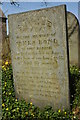
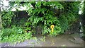
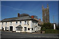
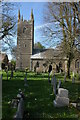
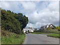
St Peter’s Well is located in St Peter’s Well Lane near the church of St John the Baptist (which used to be St Peter’s) in Bradworthy.
The well gives the impression of being forgotten as it sits in a hedge bank in a back lane of Bradworthy …. well, almost forgotten but not by the elderly gentleman who not only knew it’s location but, despite considerable difficulty in walking, insisted on accompanying us to the well. It was used as a water supply in the past and water still runs from it and into the lane. The door is locked and an ageing metal plate proclaims it as “St Peter’s Well”.
You may be viewing yesterday's version of this page. To see the most up to date information please register for a free account.
 (PID:172736)")
Do not use the above information on other web sites or publications without permission of the contributor.
Nearby Images from Geograph Britain and Ireland:
©2007(licence)
©2022(licence)
©2007(licence)
©2007(licence)
©2013(licence)
The above images may not be of the site on this page, they are loaded from Geograph.
Please Submit an Image of this site or go out and take one for us!
Click here to see more info for this site
Nearby sites
Key: Red: member's photo, Blue: 3rd party photo, Yellow: other image, Green: no photo - please go there and take one, Grey: site destroyed
Download sites to:
KML (Google Earth)
GPX (GPS waypoints)
CSV (Garmin/Navman)
CSV (Excel)
To unlock full downloads you need to sign up as a Contributory Member. Otherwise downloads are limited to 50 sites.
Turn off the page maps and other distractions
Nearby sites listing. In the following links * = Image available
4.6km SSE 158° High Barrow* Round Barrow(s) (SS3410209563)
6.0km WSW 255° Taylors Cross Tumuli* Round Barrow(s) (SS2669012535)
6.5km S 181° Ugworthy Beacon Barrows* Round Barrow(s) (SS3217607440)
6.8km WNW 292° Woolley Long Barrow* Long Barrow (SS2627516605)
6.8km NW 323° Gorvin West Barrows* Round Barrow(s) (SS2859519471)
6.8km ENE 57° Wrangworthy Cross* Barrow Cemetery (SS384174)
7.2km W 270° Wrasford Moor Barrow Cemetary* Barrow Cemetery (SS2529114170)
8.6km E 99° St Petrock's Well Devon* Holy Well or Sacred Spring (SS4095912219)
9.0km NW 313° Bursdon Moor Barrow Cemetery* Round Barrow(s) (SS2611220257)
9.7km N 350° Clovelly Dykes* Hillfort (SS311235)
10.3km SSE 167° Holsworthy St Peter’s Well Holy Well or Sacred Spring (SS345038)
10.6km WNW 293° St Nectan's Well (Welcombe)* Holy Well or Sacred Spring (SS228183)
10.9km NW 321° St Clare's Well* Holy Well or Sacred Spring (SS2582422541)
11.4km NNE 26° Peppercombe Castle Hillfort (SS379240)
11.5km SW 223° St Swithin's Well (Launcells)* Holy Well or Sacred Spring (SS244057)
11.9km SW 233° Stamford Hill settlement* Ancient Village or Settlement (SS22750705)
11.9km W 275° St John's Well (Morwenstow)* Holy Well or Sacred Spring (SS2064815298)
11.9km WSW 237° Earthquake Cist* Cist (SS22250773)
12.0km W 275° Morwenstow Churchyard Cross* Ancient Cross (SS20551527)
12.3km ESE 110° Devil's Stone, Shebbear* Standing Stone (Menhir) (SS43880925)
12.5km NW 321° St Leonard's Well (Hartland)* Holy Well or Sacred Spring (SS2486423870)
12.8km SE 128° Holemoor Well* Holy Well or Sacred Spring (SS423057)
12.8km W 275° St Morwenna's Well* Holy Well or Sacred Spring (SS1980215483)
13.5km WSW 243° Northcott Mouth Tumuli* Barrow Cemetery (SS203081)
13.7km S 180° Affaland Moor Bowl Barrow* Round Barrow(s) (SS3196200184)
View more nearby sites and additional images


 We would like to know more about this location. Please feel free to add a brief description and any relevant information in your own language.
 Wir möchten mehr über diese Stätte erfahren. Bitte zögern Sie nicht, eine kurze Beschreibung und relevante Informationen in Deutsch hinzuzufügen.
 Nous aimerions en savoir encore un peu sur les lieux. S'il vous plaît n'hesitez pas à ajouter une courte description et tous les renseignements pertinents dans votre propre langue.
 Quisieramos informarnos un poco más de las lugares. No dude en añadir una breve descripción y otros datos relevantes en su propio idioma.