


<< Our Photo Pages >> Castlehill Fort (Bearsden) - Hillfort in Scotland in East Dunbartonshire
Submitted by Antonine on Monday, 01 August 2022 Page Views: 516
Iron Age and Later PrehistorySite Name: Castlehill Fort (Bearsden)Country: Scotland
NOTE: This site is 1.459 km away from the location you searched for.
County: East Dunbartonshire Type: Hillfort
Nearest Town: Milngavie Nearest Village: Bearsden
Map Ref: NS5248272614
Latitude: 55.923909N Longitude: 4.362409W
Condition:
| 5 | Perfect |
| 4 | Almost Perfect |
| 3 | Reasonable but with some damage |
| 2 | Ruined but still recognisable as an ancient site |
| 1 | Pretty much destroyed, possibly visible as crop marks |
| 0 | No data. |
| -1 | Completely destroyed |
| 5 | Superb |
| 4 | Good |
| 3 | Ordinary |
| 2 | Not Good |
| 1 | Awful |
| 0 | No data. |
| 5 | Can be driven to, probably with disabled access |
| 4 | Short walk on a footpath |
| 3 | Requiring a bit more of a walk |
| 2 | A long walk |
| 1 | In the middle of nowhere, a nightmare to find |
| 0 | No data. |
| 5 | co-ordinates taken by GPS or official recorded co-ordinates |
| 4 | co-ordinates scaled from a detailed map |
| 3 | co-ordinates scaled from a bad map |
| 2 | co-ordinates of the nearest village |
| 1 | co-ordinates of the nearest town |
| 0 | no data |
Internal Links:
External Links:
 (PID:245340)")
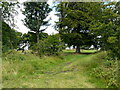
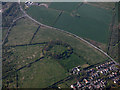
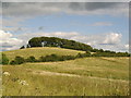
Castlehill Fort is a Roman Fortlet on the Antonine Wall south of the A810.
The fort was mostly located on the east slope of the hill. No remains are visible today, but there are good views along the line of the Antonine Wall from the summit. The fort was identified by an altar found in 1826 and a column capital found in 1847. Distance slabs found here are on display in the Hunterian Museum, Glasgow. Antonine pottery was found in the roots of the fallen trees on the summit.
There is now a beech tree plantation on the top of the hill.
[For an image of one of the distance slabs see our site page for the 'Hunterian Museum'. There are a number of separate Canmore site records for the fort, the distance slabs and an altar - see 44510 (fort); 44571 (altar); 44521 (distance slab); and 44511 (distance slab).]
You may be viewing yesterday's version of this page. To see the most up to date information please register for a free account.
Do not use the above information on other web sites or publications without permission of the contributor.
Nearby Images from Geograph Britain and Ireland:
©2021(licence)
©2017(licence)

©2015(licence)

©2021(licence)
©2007(licence)
The above images may not be of the site on this page, they are loaded from Geograph.
Please Submit an Image of this site or go out and take one for us!
Click here to see more info for this site
Nearby sites
Key: Red: member's photo, Blue: 3rd party photo, Yellow: other image, Green: no photo - please go there and take one, Grey: site destroyed
Download sites to:
KML (Google Earth)
GPX (GPS waypoints)
CSV (Garmin/Navman)
CSV (Excel)
To unlock full downloads you need to sign up as a Contributory Member. Otherwise downloads are limited to 50 sites.
Turn off the page maps and other distractions
Nearby sites listing. In the following links * = Image available
1.8km NW 320° Whitehill 5* Rock Art (NS51387403)
1.8km NW 317° Whitehill 4* Rock Art (NS51307398)
1.8km NW 311° Whitehill 3* Rock Art (NS51157386)
2.2km ESE 102° Bearsden Roman Bath-house* Stone Fort or Dun (NS54627208)
2.4km WNW 300° The Cochno Stone* Rock Art (NS50457388)
2.4km WNW 293° Auchnacraig 4* Rock Art (NS50297362)
2.4km WNW 293° Auchnacraig 1* Rock Art (NS50287365)
2.4km WNW 303° Cochno Crags* Natural Stone / Erratic / Other Natural Feature (NS50487401)
2.5km WNW 299° Auchnacraig Stone Circle* Stone Circle (NS50347391)
2.6km WNW 291° Auchnacraig 5* Rock Art (NS501736)
3.0km W 269° Golden Hill Roman Fort* Stone Fort or Dun (NS49517265)
3.0km W 270° Antonine Wall remains below Golden Hill* Stone Fort or Dun (NS49467274)
3.2km E 94° Antonine Wall, New Kilpatrick Cemetery* Misc. Earthwork (NS557723)
5.1km NNE 27° Echo Stone (Mugdock) Natural Stone / Erratic / Other Natural Feature (NS54937710)
5.4km NE 40° Middleton Row Stone Row / Alignment (NS561766)
5.6km N 351° Craigenkirn (New Kilpatrick) Cairn (NS5183978157)
5.9km W 263° Kilpatrick Crannog Crannog (NS4658172121)
6.3km ENE 62° Blochairn 1 Cairn Cairn (NS582754)
6.4km NE 39° Loch Ardinning (Mugdock) Rock Art (NS567775)
6.5km ENE 56° Craigmaddie Muir 2 (Baldernock) Cairn (NS5876)
6.6km NE 55° North Blochairn 1 Rock Art (NS58087623)
6.7km NE 55° North Blochairn 2 Rock Art (NS58147623)
6.9km NE 54° North Blochairn 3* Rock Art (NS58187646)
6.9km NE 54° Auld Wives Lift* Natural Stone / Erratic / Other Natural Feature (NS5818576458)
6.9km W 265° Erskine Park* Ancient Village or Settlement (NS45607220)
View more nearby sites and additional images


 We would like to know more about this location. Please feel free to add a brief description and any relevant information in your own language.
 Wir möchten mehr über diese Stätte erfahren. Bitte zögern Sie nicht, eine kurze Beschreibung und relevante Informationen in Deutsch hinzuzufügen.
 Nous aimerions en savoir encore un peu sur les lieux. S'il vous plaît n'hesitez pas à ajouter une courte description et tous les renseignements pertinents dans votre propre langue.
 Quisieramos informarnos un poco más de las lugares. No dude en añadir una breve descripción y otros datos relevantes en su propio idioma.