

<< Our Photo Pages >> Diévet Dolmen - Burial Chamber or Dolmen in France in Bretagne:Finistère (29)
Submitted by TheCaptain on Tuesday, 28 December 2004 Page Views: 7325
Neolithic and Bronze AgeSite Name: Diévet Dolmen Alternative Name: Dolmen de DiévetCountry: France
NOTE: This site is 0.485 km away from the location you searched for.
Département: Bretagne:Finistère (29) Type: Burial Chamber or Dolmen
Nearest Town: Lesneven Nearest Village: Plounéour-Trez
Latitude: 48.654700N Longitude: 4.3121W
Condition:
| 5 | Perfect |
| 4 | Almost Perfect |
| 3 | Reasonable but with some damage |
| 2 | Ruined but still recognisable as an ancient site |
| 1 | Pretty much destroyed, possibly visible as crop marks |
| 0 | No data. |
| -1 | Completely destroyed |
| 5 | Superb |
| 4 | Good |
| 3 | Ordinary |
| 2 | Not Good |
| 1 | Awful |
| 0 | No data. |
| 5 | Can be driven to, probably with disabled access |
| 4 | Short walk on a footpath |
| 3 | Requiring a bit more of a walk |
| 2 | A long walk |
| 1 | In the middle of nowhere, a nightmare to find |
| 0 | No data. |
| 5 | co-ordinates taken by GPS or official recorded co-ordinates |
| 4 | co-ordinates scaled from a detailed map |
| 3 | co-ordinates scaled from a bad map |
| 2 | co-ordinates of the nearest village |
| 1 | co-ordinates of the nearest town |
| 0 | no data |
Internal Links:
External Links:
I have visited· I would like to visit
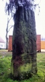
TheCaptain visited on 16th Apr 2014 - their rating: Cond: 4 Amb: 3 Access: 4 Now completely surrounded by cultivated fields, the remains of this allée couvert are easily found to the west of the hamlet of Diévet. What remains are two parallel rows of orthostats (12 in total), between 10 and 11 metres in length by 1.5 metres wide, and with a single large coverstone remaining in the middle.
terry visited on 18th May 2011 - their rating: Cond: 3 Amb: 2 Access: 4 Signpost on left of road, set back. Simply says 'Dolmen'
johnstone visited on 16th Jun 2003 - their rating: Cond: 4 Amb: 3 Access: 4
Average ratings for this site from all visit loggers: Condition: 3.67 Ambience: 2.67 Access: 4
")
What remains are two parallel rows of orthostats (12 in total), between 10 and 11 metres in length by 1.5 metres wide, and with a single large coverstone remaining in the middle.
You may be viewing yesterday's version of this page. To see the most up to date information please register for a free account.
")
")
")
")
")
")
")
")
")
")
Do not use the above information on other web sites or publications without permission of the contributor.
Click here to see more info for this site
Nearby sites
Click here to view sites on an interactive map of the areaKey: Red: member's photo, Blue: 3rd party photo, Yellow: other image, Green: no photo - please go there and take one, Grey: site destroyed
Download sites to:
KML (Google Earth)
GPX (GPS waypoints)
CSV (Garmin/Navman)
CSV (Excel)
To unlock full downloads you need to sign up as a Contributory Member. Otherwise downloads are limited to 50 sites.
Turn off the page maps and other distractions
Nearby sites listing. In the following links * = Image available
959m W 275° Menoignon menhir* Standing Stone (Menhir)
2.4km NW 316° Men-Marz* Standing Stone (Menhir)
3.1km S 173° Fontaine de St Goulven* Holy Well or Sacred Spring
3.3km W 267° Croazou chapel menhir* Standing Stone (Menhir)
3.3km W 268° Croazou chapel stèles Standing Stone (Menhir)
3.3km W 267° Croazou chapel* Ancient Cross
4.0km SSE 158° Créac'h Gallic* Passage Grave
4.1km SW 219° Dolmen de Kerbervas* Burial Chamber or Dolmen
4.6km WNW 288° Bassins de Menenham Rock Art
5.2km W 267° Menhir de Kervizouarn Standing Stone (Menhir)
5.9km E 100° Stèle dite Ar Groaz Standing Stone (Menhir)
6.0km ESE 104° Menhir de Brétouaré 1 Standing Stone (Menhir)
6.1km ESE 108° Dolmen de Brétouaré Burial Chamber or Dolmen
6.2km ESE 108° Menhir de Brétouaré 2 Standing Stone (Menhir)
6.7km ESE 105° Calvaire de Menez-ar-Plour Standing Stone (Menhir)
6.8km E 97° Menhir de Kernic Standing Stone (Menhir)
7.1km E 88° Guinivrit* Passage Grave
7.7km E 79° Porz Ar Stréat menhir* Standing Stone (Menhir)
7.7km W 259° Allée Couverte de Porz Huel* Passage Grave
8.2km E 84° Prat Meur menhir* Standing Stone (Menhir)
8.5km ESE 120° Parc Ar ouest menhir Standing Stone (Menhir)
8.5km ESE 120° Parc Ar est menhir Standing Stone (Menhir)
8.9km SW 232° Fontaine de Saint-Gildas* Holy Well or Sacred Spring
9.0km S 173° Caveau de Gouer Ven Burial Chamber or Dolmen
9.3km S 185° Musée du Léon* Museum
View more nearby sites and additional images


 We would like to know more about this location. Please feel free to add a brief description and any relevant information in your own language.
 Wir möchten mehr über diese Stätte erfahren. Bitte zögern Sie nicht, eine kurze Beschreibung und relevante Informationen in Deutsch hinzuzufügen.
 Nous aimerions en savoir encore un peu sur les lieux. S'il vous plaît n'hesitez pas à ajouter une courte description et tous les renseignements pertinents dans votre propre langue.
 Quisieramos informarnos un poco más de las lugares. No dude en añadir una breve descripción y otros datos relevantes en su propio idioma.