


<< Our Photo Pages >> Carmarthen Museum - Museum in Wales in Carmarthenshire
Submitted by davidmorgan on Friday, 13 November 2015 Page Views: 2159
MuseumsSite Name: Carmarthen MuseumCountry: Wales
NOTE: This site is 2.151 km away from the location you searched for.
County: Carmarthenshire Type: Museum
Nearest Town: Carmarthen Nearest Village: Abergwili
Map Ref: SN4408620973
Latitude: 51.865489N Longitude: 4.265824W
Condition:
| 5 | Perfect |
| 4 | Almost Perfect |
| 3 | Reasonable but with some damage |
| 2 | Ruined but still recognisable as an ancient site |
| 1 | Pretty much destroyed, possibly visible as crop marks |
| 0 | No data. |
| -1 | Completely destroyed |
| 5 | Superb |
| 4 | Good |
| 3 | Ordinary |
| 2 | Not Good |
| 1 | Awful |
| 0 | No data. |
| 5 | Can be driven to, probably with disabled access |
| 4 | Short walk on a footpath |
| 3 | Requiring a bit more of a walk |
| 2 | A long walk |
| 1 | In the middle of nowhere, a nightmare to find |
| 0 | No data. |
| 5 | co-ordinates taken by GPS or official recorded co-ordinates |
| 4 | co-ordinates scaled from a detailed map |
| 3 | co-ordinates scaled from a bad map |
| 2 | co-ordinates of the nearest village |
| 1 | co-ordinates of the nearest town |
| 0 | no data |
Internal Links:
External Links:
I have visited· I would like to visit
PERKYPUFFIN has visited here
")
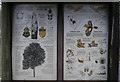
"Eleven galleries take you through 50,000 years of history".
Opening Times: Open all year (closed over the Christmas period) Tues - Sat: 10am - 4.30pm
Entrance: Free
Website: Carmarthen Museum
You may be viewing yesterday's version of this page. To see the most up to date information please register for a free account.
")
Do not use the above information on other web sites or publications without permission of the contributor.
Nearby Images from Geograph Britain and Ireland:
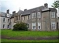
©2012(licence)
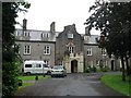
©2008(licence)
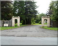
©2012(licence)
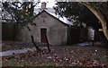
©2012(licence)
©2012(licence)
The above images may not be of the site on this page, they are loaded from Geograph.
Please Submit an Image of this site or go out and take one for us!
Click here to see more info for this site
Nearby sites
Key: Red: member's photo, Blue: 3rd party photo, Yellow: other image, Green: no photo - please go there and take one, Grey: site destroyed
Download sites to:
KML (Google Earth)
GPX (GPS waypoints)
CSV (Garmin/Navman)
CSV (Excel)
To unlock full downloads you need to sign up as a Contributory Member. Otherwise downloads are limited to 50 sites.
Turn off the page maps and other distractions
Nearby sites listing. In the following links * = Image available
1.3km ENE 65° Merlin's Stone (Carmarthen)* Standing Stone (Menhir) (SN453215)
1.5km ENE 68° Merlins Hill Hillfort* Hillfort (SN455215)
1.9km E 84° Carreg Annell* Standing Stone (Menhir) (SN4595421098)
2.0km E 82° Felin-Wen-Isaf* Round Barrow(s) (SN461212)
3.3km NNW 338° Preswyfla Standing Stone* Standing Stone (Menhir) (SN42942412)
3.8km NW 307° Maesgwyn Fort* Hillfort (SN411234)
4.0km NNW 341° Cwmhawddgar Standing Stone* Standing Stone (Menhir) (SN4288124790)
5.1km NE 36° Parc-y-Gaer* Hillfort (SN47212500)
5.2km WNW 301° Garn-Fawr Hillfort (SN397238)
5.4km E 88° Nantgaredig Standing Stones* Standing Stones (SN495210)
5.4km NW 304° Crugiau Garn Fawr* Barrow Cemetery (SN39682419)
5.5km WNW 303° Crug Tumuli* Round Barrow(s) (SN396241)
5.5km NNE 18° Meini-Gwyn* Stone Row / Alignment (SN4598126102)
5.5km NNE 25° Croes Arthur Hillfort* Hillfort (SN46602585)
5.8km NNE 20° Bull Hall Crug Cairn (SN46272631)
5.8km NNE 21° Pant-y-llyn Cairn (SN46352635)
6.0km NNW 340° Bryncennau standing stone* Standing Stone (Menhir) (SN42192662)
6.1km SSW 206° Ffynnon Berwyn* Holy Well or Sacred Spring (SN4127615577)
6.1km SSE 163° Garreg Goch* Standing Stone (Menhir) (SN45651508)
6.1km SSE 165° Pystyll Gwyn* Standing Stone (Menhir) (SN4553615017)
7.0km NNE 27° Crug-y-Rhyd-Hir* Cairn (SN47422714)
7.2km S 179° Maen Hir (Cloigyn)* Standing Stone (Menhir) (SN4393713807)
7.2km E 98° Ffinnant Fort Hillfort (SN512197)
7.7km WNW 292° Cilcrug Hillfort (SN37002416)
7.8km NNW 338° Ffosymaen* Standing Stone (Menhir) (SN414283)
View more nearby sites and additional images


 We would like to know more about this location. Please feel free to add a brief description and any relevant information in your own language.
 Wir möchten mehr über diese Stätte erfahren. Bitte zögern Sie nicht, eine kurze Beschreibung und relevante Informationen in Deutsch hinzuzufügen.
 Nous aimerions en savoir encore un peu sur les lieux. S'il vous plaît n'hesitez pas à ajouter une courte description et tous les renseignements pertinents dans votre propre langue.
 Quisieramos informarnos un poco más de las lugares. No dude en añadir una breve descripción y otros datos relevantes en su propio idioma.