

<< Our Photo Pages >> Rame Head - Hillfort in England in Cornwall
Submitted by Thorgrim on Wednesday, 11 August 2004 Page Views: 9259
Iron Age and Later PrehistorySite Name: Rame HeadCountry: England County: Cornwall Type: Hillfort
Nearest Town: Plymouth Nearest Village: Millbrook
Map Ref: SX41804825
Latitude: 50.312913N Longitude: 4.223272W
Condition:
| 5 | Perfect |
| 4 | Almost Perfect |
| 3 | Reasonable but with some damage |
| 2 | Ruined but still recognisable as an ancient site |
| 1 | Pretty much destroyed, possibly visible as crop marks |
| 0 | No data. |
| -1 | Completely destroyed |
| 5 | Superb |
| 4 | Good |
| 3 | Ordinary |
| 2 | Not Good |
| 1 | Awful |
| 0 | No data. |
| 5 | Can be driven to, probably with disabled access |
| 4 | Short walk on a footpath |
| 3 | Requiring a bit more of a walk |
| 2 | A long walk |
| 1 | In the middle of nowhere, a nightmare to find |
| 0 | No data. |
| 5 | co-ordinates taken by GPS or official recorded co-ordinates |
| 4 | co-ordinates scaled from a detailed map |
| 3 | co-ordinates scaled from a bad map |
| 2 | co-ordinates of the nearest village |
| 1 | co-ordinates of the nearest town |
| 0 | no data |
Internal Links:
External Links:
I have visited· I would like to visit
lucasn visited on 23rd Aug 2018 - their rating: Cond: 1 Amb: 4 Access: 3
TheCaptain have visited here
")
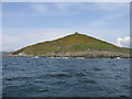
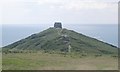
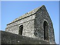
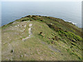
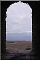
Rame Head has always been an important place, being right at the entrance to Plymouth Sound, a very important harbour. On top of the distinctive headland is the remains of a medieval chapel as well as the more modern lookout post and radar station.
You may be viewing yesterday's version of this page. To see the most up to date information please register for a free account.
")
")
Do not use the above information on other web sites or publications without permission of the contributor.
Nearby Images from Geograph Britain and Ireland:
©2006(licence)
©2005(licence)
©2005(licence)
©2012(licence)
©2019(licence)
The above images may not be of the site on this page, they are loaded from Geograph.
Please Submit an Image of this site or go out and take one for us!
Click here to see more info for this site
Nearby sites
Key: Red: member's photo, Blue: 3rd party photo, Yellow: other image, Green: no photo - please go there and take one, Grey: site destroyed
Download sites to:
KML (Google Earth)
GPX (GPS waypoints)
CSV (Garmin/Navman)
CSV (Excel)
To unlock full downloads you need to sign up as a Contributory Member. Otherwise downloads are limited to 50 sites.
Turn off the page maps and other distractions
Nearby sites listing. In the following links * = Image available
450m N 358° Garry Wells* Holy Well or Sacred Spring (SX418487)
4.8km NE 35° St Julian's Well (Maker)* Holy Well or Sacred Spring (SX447521)
5.4km NE 34° Mount Edgecombe Barrow* Round Barrow(s) (SX4495052600)
7.9km NW 325° Lady Well (Shevlock)* Holy Well or Sacred Spring (SX37425488)
8.0km NW 317° Market Cross, Crafthole* Ancient Cross (SX36505420)
8.0km NE 43° Plymouth Giants Hill Figure or Geoglyph (SX475539)
8.3km NE 47° St Helena Volcanic Stone* Modern Stone Circle etc (SX48075368)
8.5km NE 53° Mount Batten Ancient Mine, Quarry or other Industry (SX4876053196)
8.7km NW 319° Stumpy Cross* Ancient Cross (SX36285504)
9.0km NE 51° Cattedown Bone Cave Cave or Rock Shelter (SX490537)
9.9km N 351° Trehan Cross* Ancient Cross (SX405581)
10.4km ENE 63° Burrow Hill Round Barrow(s) (SX512527)
11.5km NW 325° Venton Gwavas* Holy Well or Sacred Spring (SX355579)
12.1km ENE 61° Elburton Burial Mound Round Barrow(s) (SX526538)
12.2km ENE 65° Elburton Cross* Ancient Cross (SX5304952984)
12.9km N 350° Holy Well near Saltash Holy Well or Sacred Spring (SX400610)
13.1km N 353° St Mary the Virgin (Cornwall)* Holy Well or Sacred Spring (SX4055461327)
16.4km NW 319° Padderbury Top Ancient Village or Settlement (SX3139661023)
16.5km WNW 283° St Martin's Well (Shutta) Holy Well or Sacred Spring (SX258524)
16.6km ENE 68° Wasteberry Camp Hillfort (SX5738854066)
16.8km WNW 290° Barrow near Looe Barrow Cemetery (SX2611054356)
16.9km NE 46° Boringdon Camp* Hillfort (SX544596)
17.0km WNW 286° St Mary's Well (Cornwall)* Holy Well or Sacred Spring (SX256534)
17.1km WNW 302° Bin Down (East Looe)* Ancient Village or Settlement (SX2764957830)
17.6km N 358° St Indract's Well* Holy Well or Sacred Spring (SX417659)
View more nearby sites and additional images


 We would like to know more about this location. Please feel free to add a brief description and any relevant information in your own language.
 Wir möchten mehr über diese Stätte erfahren. Bitte zögern Sie nicht, eine kurze Beschreibung und relevante Informationen in Deutsch hinzuzufügen.
 Nous aimerions en savoir encore un peu sur les lieux. S'il vous plaît n'hesitez pas à ajouter une courte description et tous les renseignements pertinents dans votre propre langue.
 Quisieramos informarnos un poco más de las lugares. No dude en añadir una breve descripción y otros datos relevantes en su propio idioma.