


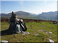
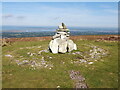
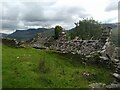
<< Our Photo Pages >> Mynydd Y Cilgwyn Cairn - Cairn in Wales in Gwynedd
Submitted by TAlanJones on Monday, 09 November 2020 Page Views: 880
Date UncertainSite Name: Mynydd Y Cilgwyn CairnCountry: Wales
NOTE: This site is 0.282 km away from the location you searched for.
County: Gwynedd Type: Cairn
Nearest Town: Pen Y Groes Nearest Village: Carmel
Map Ref: SH497543
Latitude: 53.064741N Longitude: 4.244495W
Condition:
| 5 | Perfect |
| 4 | Almost Perfect |
| 3 | Reasonable but with some damage |
| 2 | Ruined but still recognisable as an ancient site |
| 1 | Pretty much destroyed, possibly visible as crop marks |
| 0 | No data. |
| -1 | Completely destroyed |
| 5 | Superb |
| 4 | Good |
| 3 | Ordinary |
| 2 | Not Good |
| 1 | Awful |
| 0 | No data. |
| 5 | Can be driven to, probably with disabled access |
| 4 | Short walk on a footpath |
| 3 | Requiring a bit more of a walk |
| 2 | A long walk |
| 1 | In the middle of nowhere, a nightmare to find |
| 0 | No data. |
| 5 | co-ordinates taken by GPS or official recorded co-ordinates |
| 4 | co-ordinates scaled from a detailed map |
| 3 | co-ordinates scaled from a bad map |
| 2 | co-ordinates of the nearest village |
| 1 | co-ordinates of the nearest town |
| 0 | no data |
Internal Links:
External Links:
")
It may have an earlier Prehistoric history that has escaped my research but the current visual evidence suggests otherwise.
You may be viewing yesterday's version of this page. To see the most up to date information please register for a free account.
")
")
")
")
Do not use the above information on other web sites or publications without permission of the contributor.
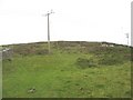
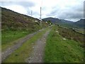
Nearby Images from Geograph Britain and Ireland:
©2023(licence)
©2023(licence)
©2008(licence)
©2024(licence)
©2024(licence)
The above images may not be of the site on this page, they are loaded from Geograph.
Please Submit an Image of this site or go out and take one for us!
Click here to see more info for this site
Nearby sites
Key: Red: member's photo, Blue: 3rd party photo, Yellow: other image, Green: no photo - please go there and take one, Grey: site destroyed
Download sites to:
KML (Google Earth)
GPX (GPS waypoints)
CSV (Garmin/Navman)
CSV (Excel)
To unlock full downloads you need to sign up as a Contributory Member. Otherwise downloads are limited to 50 sites.
Turn off the page maps and other distractions
Nearby sites listing. In the following links * = Image available
804m WNW 298° Cae Forgan Standing Stone* Standing Stone (Menhir) (SH490547)
1.0km WNW 285° Cae Forgan Cairn* Cairn (SH487546)
1.2km W 273° Pen Llwyn Farm Hut Circle Settlement* Ancient Village or Settlement (SH485544)
2.6km SW 228° Caer Engan* Hillfort (SH4767052590)
2.7km SW 229° Carreg Caer Engan* Standing Stone (Menhir) (SH4762352591)
3.0km ESE 103° Gelli Ffrydiau Hillfort* Hillfort (SH5259053560)
4.0km N 4° Gaerwen Ancient Village or Settlement (SH501583)
4.1km WNW 286° Glynllifon Monolith Standing Stone (Menhir) (SH4577055574)
4.3km ESE 121° Cwmyffynnon alignment* Natural Stone / Erratic / Other Natural Feature (SH533520)
4.3km E 83° Mynydd Mawr Cairn* Cairn (SH53965469)
4.3km W 263° Penbryn Mawr Standing Stone* Standing Stone (Menhir) (SH4537253927)
4.6km W 267° Plas Newydd Ancient Village or Settlement (SH4507954192)
4.7km ENE 75° Craig Cwmbychan Cairn* Cairn (SH54335542)
4.8km NW 314° Dinas y Prif Camp* Ancient Village or Settlement (SH4633957760)
4.9km W 281° Ffynnon Adliw Holy Well or Sacred Spring (SH4490155385)
5.0km SE 144° Craig Cwm Silyn Round Cairn* Round Cairn (SH525502)
5.0km SSE 162° Garnedd Goch Round Cairn* Round Cairn (SH511495)
5.2km W 267° Maen Llwyd (Gwynedd)* Standing Stone (Menhir) (SH4449554155)
5.4km WSW 243° Craig-y-Dinas (Penygroes)* Hillfort (SH44825198)
5.6km W 279° Bodfan Standing Stone* Standing Stone (Menhir) (SH4420555327)
5.7km ESE 105° Y Garn (Gwynedd)* Cairn (SH55135262)
6.0km S 176° Mynydd Graig Goch Round Cairn* Round Cairn (SH499483)
6.3km SW 218° Graianog Long Mound* Misc. Earthwork (SH45634951)
6.3km WNW 287° Dinas Dinlle* Hillfort (SH437563)
6.6km SW 217° Graianog Standing Stone* Standing Stone (Menhir) (SH45524918)
View more nearby sites and additional images


 We would like to know more about this location. Please feel free to add a brief description and any relevant information in your own language.
 Wir möchten mehr über diese Stätte erfahren. Bitte zögern Sie nicht, eine kurze Beschreibung und relevante Informationen in Deutsch hinzuzufügen.
 Nous aimerions en savoir encore un peu sur les lieux. S'il vous plaît n'hesitez pas à ajouter une courte description et tous les renseignements pertinents dans votre propre langue.
 Quisieramos informarnos un poco más de las lugares. No dude en añadir una breve descripción y otros datos relevantes en su propio idioma.