


<< Our Photo Pages >> Holemoor Well - Holy Well or Sacred Spring in England in Devon
Submitted by cazzyjane on Saturday, 30 July 2011 Page Views: 5378
Springs and Holy WellsSite Name: Holemoor WellCountry: England
NOTE: This site is 1.513 km away from the location you searched for.
County: Devon Type: Holy Well or Sacred Spring
Nearest Town: Holsworthy Nearest Village: Holemoor
Map Ref: SS423057
Latitude: 50.829298N Longitude: 4.240623W
Condition:
| 5 | Perfect |
| 4 | Almost Perfect |
| 3 | Reasonable but with some damage |
| 2 | Ruined but still recognisable as an ancient site |
| 1 | Pretty much destroyed, possibly visible as crop marks |
| 0 | No data. |
| -1 | Completely destroyed |
| 5 | Superb |
| 4 | Good |
| 3 | Ordinary |
| 2 | Not Good |
| 1 | Awful |
| 0 | No data. |
| 5 | Can be driven to, probably with disabled access |
| 4 | Short walk on a footpath |
| 3 | Requiring a bit more of a walk |
| 2 | A long walk |
| 1 | In the middle of nowhere, a nightmare to find |
| 0 | No data. |
| 5 | co-ordinates taken by GPS or official recorded co-ordinates |
| 4 | co-ordinates scaled from a detailed map |
| 3 | co-ordinates scaled from a bad map |
| 2 | co-ordinates of the nearest village |
| 1 | co-ordinates of the nearest town |
| 0 | no data |
Internal Links:
External Links:
I have visited· I would like to visit
cazzyjane Bolstered have visited here
")
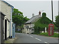
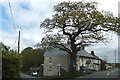
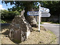
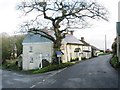
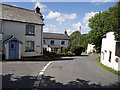
Holemoor Well. Situated at a crossroads next to an oak tree, this well-house was renovated to commemorate the Millennium. Unfortunately it's door remains padlocked.
You may be viewing yesterday's version of this page. To see the most up to date information please register for a free account.
Do not use the above information on other web sites or publications without permission of the contributor.
Nearby Images from Geograph Britain and Ireland:
©2010(licence)
©2012(licence)
©2007(licence)
©2013(licence)
©2007(licence)
The above images may not be of the site on this page, they are loaded from Geograph.
Please Submit an Image of this site or go out and take one for us!
Click here to see more info for this site
Nearby sites
Key: Red: member's photo, Blue: 3rd party photo, Yellow: other image, Green: no photo - please go there and take one, Grey: site destroyed
Download sites to:
KML (Google Earth)
GPX (GPS waypoints)
CSV (Garmin/Navman)
CSV (Excel)
To unlock full downloads you need to sign up as a Contributory Member. Otherwise downloads are limited to 50 sites.
Turn off the page maps and other distractions
Nearby sites listing. In the following links * = Image available
3.9km NNE 22° Devil's Stone, Shebbear* Standing Stone (Menhir) (SS43880925)
5.8km SSE 156° Halwill Great Barrows* Barrow Cemetery (SS4449200306)
6.3km S 174° Halwill Churchyard Cross* Ancient Cross (SX4272799412)
6.3km S 174° Halwill Village Cross* Ancient Cross (SX4275199393)
6.7km NNW 347° St Petrock's Well Devon* Holy Well or Sacred Spring (SS4095912219)
8.0km WSW 255° Holsworthy St Peter’s Well Holy Well or Sacred Spring (SS345038)
9.0km WNW 294° High Barrow* Round Barrow(s) (SS3410209563)
9.6km SSE 149° Three Barrows, Patchacott* Barrow Cemetery (SX4693097301)
9.8km E 87° Hatherleigh St. Mary's Well Holy Well or Sacred Spring (SS5213105847)
10.2km W 278° Ugworthy Beacon Barrows* Round Barrow(s) (SS3217607440)
10.5km ENE 61° Heathmoor Barrow* Barrow Cemetery (SS517105)
11.7km WSW 240° Affaland Moor Bowl Barrow* Round Barrow(s) (SS3196200184)
12.3km NNW 340° Wrangworthy Cross* Barrow Cemetery (SS384174)
12.8km NW 308° St Peter's Well (Bradworthy)* Holy Well or Sacred Spring (SS325139)
13.0km E 94° Hatherleigh St. John's Well* Holy Well or Sacred Spring (SS5523104363)
14.0km SW 231° St Denis Well, Holy Well, Sacred Spring* Holy Well or Sacred Spring (SX3109797178)
15.2km NNE 22° Coverney Well* Holy Well or Sacred Spring (SS484196)
16.2km SW 235° Mount Pleasant Barrows* Barrow Cemetery (SX28769679)
16.6km S 182° Broadwoodwidger Cross Ancient Cross (SX4112589159)
17.0km WNW 292° Taylors Cross Tumuli* Round Barrow(s) (SS2669012535)
17.5km SW 236° Kiddy Barrow* Barrow Cemetery (SX27499637)
17.5km WSW 244° St Anne's Well (Whitstone)* Holy Well or Sacred Spring (SX263985)
17.7km NE 49° Combe Wood Hillfort (SS561169)
17.8km W 268° St Swithin's Well (Launcells)* Holy Well or Sacred Spring (SS244057)
17.9km WSW 249° Froxton Wood Castle Hillfort (SX2543099705)
View more nearby sites and additional images


 We would like to know more about this location. Please feel free to add a brief description and any relevant information in your own language.
 Wir möchten mehr über diese Stätte erfahren. Bitte zögern Sie nicht, eine kurze Beschreibung und relevante Informationen in Deutsch hinzuzufügen.
 Nous aimerions en savoir encore un peu sur les lieux. S'il vous plaît n'hesitez pas à ajouter une courte description et tous les renseignements pertinents dans votre propre langue.
 Quisieramos informarnos un poco más de las lugares. No dude en añadir una breve descripción y otros datos relevantes en su propio idioma.