


<< Text Pages >> St Gredifael's Holy Well (Penmynydd) - Holy Well or Sacred Spring in Wales in Anglesey
Submitted by Sunny100 on Wednesday, 29 December 2010 Page Views: 6566
Springs and Holy WellsSite Name: St Gredifael's Holy Well (Penmynydd) Alternative Name: Ffynnon GredifaelCountry: Wales
NOTE: This site is 0.86 km away from the location you searched for.
County: Anglesey Type: Holy Well or Sacred Spring
Nearest Town: Beaumaris Nearest Village: Penmynydd
Map Ref: SH51677465
Latitude: 53.248079N Longitude: 4.224554W
Condition:
| 5 | Perfect |
| 4 | Almost Perfect |
| 3 | Reasonable but with some damage |
| 2 | Ruined but still recognisable as an ancient site |
| 1 | Pretty much destroyed, possibly visible as crop marks |
| 0 | No data. |
| -1 | Completely destroyed |
| 5 | Superb |
| 4 | Good |
| 3 | Ordinary |
| 2 | Not Good |
| 1 | Awful |
| 0 | No data. |
| 5 | Can be driven to, probably with disabled access |
| 4 | Short walk on a footpath |
| 3 | Requiring a bit more of a walk |
| 2 | A long walk |
| 1 | In the middle of nowhere, a nightmare to find |
| 0 | No data. |
| 5 | co-ordinates taken by GPS or official recorded co-ordinates |
| 4 | co-ordinates scaled from a detailed map |
| 3 | co-ordinates scaled from a bad map |
| 2 | co-ordinates of the nearest village |
| 1 | co-ordinates of the nearest town |
| 0 | no data |
Internal Links:
External Links:
I have visited· I would like to visit
PAB has visited here
St Gredifael's Holy Well's waters were regarded as curative and, according to Francis Jones in 'The Holy Wells of Wales' 1992 "its waters were used in order to cure warts, which were first pricked with a pin, until they bled, then washed in the well".
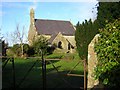
St Gredifael, son of king Ithael Hoel, founded Penmynydd (Llanredifael) church in the 6th century CE. He was a disciple of St Padarn. In later life he became abbot of a Celtic monastery at Whitland (Hendygwyn-ar-Daf), Pembrokeshire.
You may be viewing yesterday's version of this page. To see the most up to date information please register for a free account.
Do not use the above information on other web sites or publications without permission of the contributor.
Nearby Images from Geograph Britain and Ireland:
©2007(licence)
©2008(licence)
©2008(licence)
©2008(licence)
©2006(licence)
The above images may not be of the site on this page, they are loaded from Geograph.
Please Submit an Image of this site or go out and take one for us!
Click here to see more info for this site
Nearby sites
Key: Red: member's photo, Blue: 3rd party photo, Yellow: other image, Green: no photo - please go there and take one, Grey: site destroyed
Download sites to:
KML (Google Earth)
GPX (GPS waypoints)
CSV (Garmin/Navman)
CSV (Excel)
To unlock full downloads you need to sign up as a Contributory Member. Otherwise downloads are limited to 50 sites.
Turn off the page maps and other distractions
Nearby sites listing. In the following links * = Image available
3.3km W 266° Hirdre-faig* Standing Stone (Menhir) (SH484745)
3.3km SE 137° Ty Mawr Tomb* Passage Grave (SH5388672144)
3.7km E 99° Ty-Gwyn* Standing Stone (Menhir) (SH5536273949)
3.9km NNW 347° Llanddyfynan Barrows* Chambered Tomb (SH5088278462)
3.9km NNE 15° The Three Leaps* Stone Row / Alignment (SH5283878407)
4.2km NNW 337° Llanddfynan Standing Stone* Standing Stone (Menhir) (SH5014978592)
4.3km NE 50° Hendrefor* Chambered Tomb (SH551773)
4.4km NNE 27° Mynydd Llwydiarth Hillfort (SH5378978520)
4.5km SSW 196° Tyddyn-bach* Standing Stone (Menhir) (SH5031770341)
4.5km SSW 192° Bryn Celli Ddu Gorsedd* Rock Art (SH50627024)
4.6km S 190° Bryn Celli Ddu* Passage Grave (SH50757017)
4.6km S 190° Bryn Celli Ddu Cairn* Cairn (SH50727012)
4.7km S 191° Bryn Celli Ddu Standing Stone* Standing Stone (Menhir) (SH50637010)
4.8km E 97° Pen-Y-Maen* Standing Stone (Menhir) (SH564739)
4.9km S 175° Plas Newydd Burial Chamber* Chambered Tomb (SH5199069722)
4.9km SE 127° Menai Bridge Gorsedd Circle* Modern Stone Circle etc (SH55517153)
5.4km W 279° Llangefni Gorsedd Circle Modern Stone Circle etc (SH4636875687)
5.5km NNE 16° Traeth Coch Pentraeth Standing Stone* Marker Stone (SH534799)
5.6km S 176° Bryn yr Hen Bobl* Chambered Cairn (SH5188869005)
6.0km W 280° Ffynnon Cyngar Sant / St Cyngars Well* Holy Well or Sacred Spring (SH4572875881)
6.1km W 262° Lledwigan* Standing Stone (Menhir) (SH456740)
6.1km SE 139° Goetre Uchaf Barrow* Round Barrow(s) (SH5556069900)
6.2km WNW 287° Oriel Ynys Mon* Museum (SH458766)
6.2km ENE 62° Cremlyn 2* Standing Stone (Menhir) (SH573774)
6.3km ENE 60° Cremlyn 1* Standing Stone (Menhir) (SH572776)
View more nearby sites and additional images


 We would like to know more about this location. Please feel free to add a brief description and any relevant information in your own language.
 Wir möchten mehr über diese Stätte erfahren. Bitte zögern Sie nicht, eine kurze Beschreibung und relevante Informationen in Deutsch hinzuzufügen.
 Nous aimerions en savoir encore un peu sur les lieux. S'il vous plaît n'hesitez pas à ajouter une courte description et tous les renseignements pertinents dans votre propre langue.
 Quisieramos informarnos un poco más de las lugares. No dude en añadir una breve descripción y otros datos relevantes en su propio idioma.