

<< Text Pages >> Alignement de Goulheo - Stone Row / Alignment in France in Bretagne:Finistère (29)
Submitted by holger_rix on Tuesday, 17 May 2016 Page Views: 702
Neolithic and Bronze AgeSite Name: Alignement de GoulheoCountry: France
NOTE: This site is 1.63 km away from the location you searched for.
Département: Bretagne:Finistère (29) Type: Stone Row / Alignment
Nearest Town: Brest Nearest Village: Landerneau
Latitude: 48.441117N Longitude: 4.252052W
Condition:
| 5 | Perfect |
| 4 | Almost Perfect |
| 3 | Reasonable but with some damage |
| 2 | Ruined but still recognisable as an ancient site |
| 1 | Pretty much destroyed, possibly visible as crop marks |
| 0 | No data. |
| -1 | Completely destroyed |
| 5 | Superb |
| 4 | Good |
| 3 | Ordinary |
| 2 | Not Good |
| 1 | Awful |
| 0 | No data. |
| 5 | Can be driven to, probably with disabled access |
| 4 | Short walk on a footpath |
| 3 | Requiring a bit more of a walk |
| 2 | A long walk |
| 1 | In the middle of nowhere, a nightmare to find |
| 0 | No data. |
| 5 | co-ordinates taken by GPS or official recorded co-ordinates |
| 4 | co-ordinates scaled from a detailed map |
| 3 | co-ordinates scaled from a bad map |
| 2 | co-ordinates of the nearest village |
| 1 | co-ordinates of the nearest town |
| 0 | no data |
Be the first person to rate this site - see the 'Contribute!' box in the right hand menu.
Internal Links:
External Links:
Stone Row / Alignment in Bretagne:Finistère (29)
Le Bois Noir, Landerneau, Brest, Finistère, Brittany
Source: T4T35
Information and Pictures:
t4t35.fr
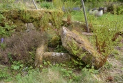
"Alignement de 5 menhirs au bord d'un talus. Ils mensurent entre 2 m et 4 m et sont tous renversés, sauf un en appuie sur un talus. Dans le bois d'autres pierres imposantes."
"Aligning 5 menhirs near a slope. They measure between 2 m and 4 m and are overthrown, but one based on a slope. In close wood other big stones."
You may be viewing yesterday's version of this page. To see the most up to date information please register for a free account.
Do not use the above information on other web sites or publications without permission of the contributor.
Nearby Images from Flickr


The above images may not be of the site on this page, but were taken nearby. They are loaded from Flickr so please click on them for image credits.
Click here to see more info for this site
Nearby sites
Click here to view sites on an interactive map of the areaKey: Red: member's photo, Blue: 3rd party photo, Yellow: other image, Green: no photo - please go there and take one, Grey: site destroyed
Download sites to:
KML (Google Earth)
GPX (GPS waypoints)
CSV (Garmin/Navman)
CSV (Excel)
To unlock full downloads you need to sign up as a Contributory Member. Otherwise downloads are limited to 50 sites.
Turn off the page maps and other distractions
Nearby sites listing. In the following links * = Image available
2.8km SW 231° Menhir de Kerloussouarn Standing Stone (Menhir)
5.5km S 186° Pierre de Sainte-Nonne Rock Art
7.4km NNE 29° Pierres à Cupules de Kerizella Rock Art
8.2km SW 227° Carn menhir (Loperhet) Standing Stone (Menhir)
8.4km ENE 59° Allée Couverte de Gorré-Coat Passage Grave
10.7km NW 311° Prat Ledan menhir* Standing Stone (Menhir)
10.8km SW 218° Lanvrizan menhir Standing Stone (Menhir)
12.8km S 187° Croix des Douze Apôtres* Standing Stone (Menhir)
15.2km NNW 347° Caveau de Gouer Ven Burial Chamber or Dolmen
15.4km NNW 340° Musée du Léon* Museum
17.7km SW 229° Menhirs de Kerziou Stone Row / Alignment
18.9km NNE 14° Landeguiarc'h menhir Standing Stone (Menhir)
19.6km SSW 198° Allée Couverte de Quiniquidec 1 Passage Grave
19.8km N 9° Parc Ar ouest menhir Standing Stone (Menhir)
19.8km N 9° Parc Ar est menhir Standing Stone (Menhir)
19.8km SSW 197° Allée Couverte de Quiniquidec 2 Passage Grave
20.2km N 352° Créac'h Gallic* Passage Grave
20.3km E 95° Quillidiec menhir Standing Stone (Menhir)
20.7km E 88° Menhir de Kerouandal Standing Stone (Menhir)
20.8km WSW 250° Menhir de Kerastel Standing Stone (Menhir)
21.0km S 190° Menhir de Kernevez Standing Stone (Menhir)
21.1km N 349° Fontaine de St Goulven* Holy Well or Sacred Spring
21.5km NNW 328° Fontaine de Saint-Gildas* Holy Well or Sacred Spring
21.5km ESE 102° Mougau Bihan* Passage Grave
21.7km NNW 341° Dolmen de Kerbervas* Burial Chamber or Dolmen
View more nearby sites and additional images


 We would like to know more about this location. Please feel free to add a brief description and any relevant information in your own language.
 Wir möchten mehr über diese Stätte erfahren. Bitte zögern Sie nicht, eine kurze Beschreibung und relevante Informationen in Deutsch hinzuzufügen.
 Nous aimerions en savoir encore un peu sur les lieux. S'il vous plaît n'hesitez pas à ajouter une courte description et tous les renseignements pertinents dans votre propre langue.
 Quisieramos informarnos un poco más de las lugares. No dude en añadir una breve descripción y otros datos relevantes en su propio idioma.