 with our Megalithic Portal iPhone app")


<< Our Photo Pages >> St Mary the Virgin (Cornwall) - Holy Well or Sacred Spring in England in Cornwall
Submitted by Rory on Tuesday, 30 May 2006 Page Views: 5862
Springs and Holy WellsSite Name: St Mary the Virgin (Cornwall)Country: England
NOTE: This site is 3.163 km away from the location you searched for.
County: Cornwall Type: Holy Well or Sacred Spring
Nearest Town: Saltash Nearest Village: Botus Fleming
Map Ref: SX4055461327
Latitude: 50.430091N Longitude: 4.246303W
Condition:
| 5 | Perfect |
| 4 | Almost Perfect |
| 3 | Reasonable but with some damage |
| 2 | Ruined but still recognisable as an ancient site |
| 1 | Pretty much destroyed, possibly visible as crop marks |
| 0 | No data. |
| -1 | Completely destroyed |
| 5 | Superb |
| 4 | Good |
| 3 | Ordinary |
| 2 | Not Good |
| 1 | Awful |
| 0 | No data. |
| 5 | Can be driven to, probably with disabled access |
| 4 | Short walk on a footpath |
| 3 | Requiring a bit more of a walk |
| 2 | A long walk |
| 1 | In the middle of nowhere, a nightmare to find |
| 0 | No data. |
| 5 | co-ordinates taken by GPS or official recorded co-ordinates |
| 4 | co-ordinates scaled from a detailed map |
| 3 | co-ordinates scaled from a bad map |
| 2 | co-ordinates of the nearest village |
| 1 | co-ordinates of the nearest town |
| 0 | no data |
Internal Links:
External Links:
I have visited· I would like to visit
cazzyjane has visited here
 (PID:21016)")
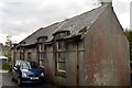
The old well house doesn’t actually have the capacity to hold water any more. In Secret Shrines Paul Broadhurst senses that the resident Naiad is long gone. I’m not so sure, because if you look through the grate in the lane’s gully you’ll see water gushing from the direction of the structure. The spring seems to be alive and kicking. Although the sacred waters don’t emerge at this point they haven’t completely abandoned the place. My wife has taught me to stop and listen to the Holy Wells. Similarly you’ll hear sound of the lost waters of St Probus and Grace emanating from a roadside drain.
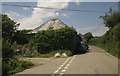
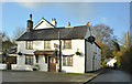
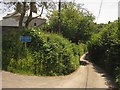
The building faces away from the main road – so it’s easy to miss. The locked gate looks like it’s designed to imprison a rather tall statue of “Our Lady,” as my wife would call her, as if in a desperate attempt to contain some of the depleted sanctity. You’ll find Saint Mary’s at the eastern side of Botus Fleming in the corner of the first turning south towards Carkeel and ultimately Saltash. It sits opposite an old schoolhouse that’s in the process of being renovated.
Just to note that although this is a fitting sculpture, sometimes the choice of figurine in a well house is quite arbitrary. At Saint Indract’s Well a statue of Jesus, complete with sacred heart, is displayed because, “he looked like a monk.” Makes you wonder if the incorporation of the famous carved head inside the Saint Anne’s well house, in Whitstone, was as carefully considered as we all suppose. Maybe the builders just thought the back wall needed a focal point, something to draw the eye. Which indeed it does, in spades.
You may be viewing yesterday's version of this page. To see the most up to date information please register for a free account.
 (PID:84963)")
Do not use the above information on other web sites or publications without permission of the contributor.
davidmorgan has found this location on Google Street View:
Nearby Images from Geograph Britain and Ireland:
©2018(licence)
©2013(licence)
©2009(licence)
©2018(licence)
©2013(licence)
The above images may not be of the site on this page, they are loaded from Geograph.
Please Submit an Image of this site or go out and take one for us!
Click here to see more info for this site
Nearby sites
Key: Red: member's photo, Blue: 3rd party photo, Yellow: other image, Green: no photo - please go there and take one, Grey: site destroyed
Download sites to:
KML (Google Earth)
GPX (GPS waypoints)
CSV (Garmin/Navman)
CSV (Excel)
To unlock full downloads you need to sign up as a Contributory Member. Otherwise downloads are limited to 50 sites.
Turn off the page maps and other distractions
Nearby sites listing. In the following links * = Image available
642m WSW 238° Holy Well near Saltash Holy Well or Sacred Spring (SX400610)
3.2km S 179° Trehan Cross* Ancient Cross (SX405581)
4.7km NNE 12° St Indract's Well* Holy Well or Sacred Spring (SX417659)
6.1km SW 234° Venton Gwavas* Holy Well or Sacred Spring (SX355579)
7.2km SSW 204° Lady Well (Shevlock)* Holy Well or Sacred Spring (SX37425488)
7.6km SSW 212° Stumpy Cross* Ancient Cross (SX36285504)
8.0km NNW 333° Castlewitch Henge* Henge (SX37086854)
8.2km SSW 208° Market Cross, Crafthole* Ancient Cross (SX36505420)
8.3km NW 307° Collects Well* Holy Well or Sacred Spring (SX3399466483)
8.6km NNW 337° Dupath Well* Holy Well or Sacred Spring (SX374693)
8.8km NW 313° Cadson Bury* Hillfort (SX342675)
9.1km W 266° Padderbury Top Ancient Village or Settlement (SX3139661023)
9.3km NW 320° Frogwell* Holy Well or Sacred Spring (SX347686)
9.5km NNW 329° Lady's Well (Callington)* Holy Well or Sacred Spring (SX359696)
9.8km SSE 152° Mount Edgecombe Barrow* Round Barrow(s) (SX4495052600)
9.8km WNW 288° Quethiock Cross* Ancient Cross (SX31296471)
10.1km SSE 154° St Julian's Well (Maker)* Holy Well or Sacred Spring (SX447521)
10.2km SE 135° Plymouth Giants Hill Figure or Geoglyph (SX475539)
10.4km ENE 72° Roborough Down Earthworks* Hillfort (SX50556415)
10.5km NNW 341° Kit Hill Long Barrow (SX37487135)
10.5km ENE 73° Second Roborough Down Earthworks* Hillfort (SX50736407)
10.5km ENE 73° Third Roborough Down Earthworks* Misc. Earthwork (SX5077364013)
10.7km SE 134° St Helena Volcanic Stone* Modern Stone Circle etc (SX48075368)
11.4km SE 130° Cattedown Bone Cave Cave or Rock Shelter (SX490537)
11.5km SE 133° Mount Batten Ancient Mine, Quarry or other Industry (SX4876053196)
View more nearby sites and additional images


 We would like to know more about this location. Please feel free to add a brief description and any relevant information in your own language.
 Wir möchten mehr über diese Stätte erfahren. Bitte zögern Sie nicht, eine kurze Beschreibung und relevante Informationen in Deutsch hinzuzufügen.
 Nous aimerions en savoir encore un peu sur les lieux. S'il vous plaît n'hesitez pas à ajouter une courte description et tous les renseignements pertinents dans votre propre langue.
 Quisieramos informarnos un poco más de las lugares. No dude en añadir una breve descripción y otros datos relevantes en su propio idioma.