 with our Megalithic Portal iPhone app")


<< Our Photo Pages >> St. Brannoc's Holy Well (Braunton) - Holy Well or Sacred Spring in England in Devon
Submitted by AngieLake on Wednesday, 23 March 2005 Page Views: 25854
Springs and Holy WellsSite Name: St. Brannoc's Holy Well (Braunton) Alternative Name: St. Brannock's Holy WellCountry: England County: Devon Type: Holy Well or Sacred Spring
Nearest Town: Barnstaple Nearest Village: Braunton
Map Ref: SS487374
Latitude: 51.115860N Longitude: 4.163016W
Condition:
| 5 | Perfect |
| 4 | Almost Perfect |
| 3 | Reasonable but with some damage |
| 2 | Ruined but still recognisable as an ancient site |
| 1 | Pretty much destroyed, possibly visible as crop marks |
| 0 | No data. |
| -1 | Completely destroyed |
| 5 | Superb |
| 4 | Good |
| 3 | Ordinary |
| 2 | Not Good |
| 1 | Awful |
| 0 | No data. |
| 5 | Can be driven to, probably with disabled access |
| 4 | Short walk on a footpath |
| 3 | Requiring a bit more of a walk |
| 2 | A long walk |
| 1 | In the middle of nowhere, a nightmare to find |
| 0 | No data. |
| 5 | co-ordinates taken by GPS or official recorded co-ordinates |
| 4 | co-ordinates scaled from a detailed map |
| 3 | co-ordinates scaled from a bad map |
| 2 | co-ordinates of the nearest village |
| 1 | co-ordinates of the nearest town |
| 0 | no data |
Internal Links:
External Links:
I have visited· I would like to visit
geoffstickland AngieLake have visited here
 (PID:12687)")
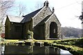
This holy well of St Brannoc, or Brannock, is tucked away in the most beautiful little dell next to a modern Catholic chapel, built on the site of an ancient medieval chapel, which had fallen into ruins by the 18th century. It is on land that belonged to a man we villagers used (in the 1950s and 60s) to call the 'Squire' of Braunton: Mr Incledon-Webber, who lived in the big house higher up the hill. I'm not sure if his descendants still own the house.
The present chapel dates from 1957, and was restored as a Catholic chapel-of-ease by Mrs Incledon-Webber as a memorial to her parents, and was rededicated in 1958.
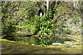
The stone-lined pool which forms the 'well' is almost heart-shaped, and there are two small flagstone piers so that one can stand closer to the water. Above the pool, in a niche in the steep rocky hillside, is a statue of Our Lady. The water seemed to be running into the pool from near its pointed edge.
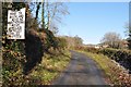
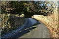
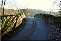
To get to this well, you must travel north, taking the Ilfracombe road from the centre of Braunton. In other words, if coming from Barnstaple, keep going straight ahead at the traffic lights. (It can be extremely busy here in summer, with all the surfers going to Croyde and Saunton!)When you pass the Parish church of St. Brannock (a fine 13th century building with pointed steeple) on your right, look out for the last building on your left, which is the fire station. Turn immediately left at that crossroads, (going over the site of the old Barnstaple to Ilfracombe railway line), and travel uphill for about 100 yards. Just after passing St Brannocks Well Close (a modern housing estate cul-de-sac on your right), you will see a drive, also to the right. This is the drive to the big house, but just to the right of its entrance is a car park for the chapel. When I visited on 20th March 2005, the gate was padlocked. As I was alone and on foot, I walked a few steps up the drive until I could cross the low bank between the drive and the (lower) lane to the well. The lane is lovely: not very long, and very narrow, with high sides, funnelling you down hill to the little chapel in the dell. When you get there, the well-pond is just to the left, and is surrounded by ferns and other greenery, etc.. The spot has a lovely ambience.
When I went to explore almost two years ago, I mistakenly turned the car into the housing estate below, and got talking to a resident who remembered me from years ago, when we lived above mum's shop in the village centre. I asked him where I could find the well, and he told me about this one, but also pointed to the bump in the field above his property, indicating that the original well was there.
Walking back to the beginning of the lane later, I opened a small gate to my left, and walked into the top of that field. There were two metal 'drain' covers, and I took a photo of them, with the roof of the chapel just visible over the brow of the field. It wasn't unusual that I knew nothing about this well, as I left the village in 1966, and up until then, like most young people, wasn't interested in history at all!
You may be viewing yesterday's version of this page. To see the most up to date information please register for a free account.
 (PID:12684)")
 (PID:193838)")
 (PID:193837)")
 (PID:12685)")
Do not use the above information on other web sites or publications without permission of the contributor.
Nearby Images from Geograph Britain and Ireland:
©2008(licence)
©2008(licence)
©2010(licence)
©2010(licence)
©2010(licence)
The above images may not be of the site on this page, they are loaded from Geograph.
Please Submit an Image of this site or go out and take one for us!
Click here to see more info for this site
Nearby sites
Key: Red: member's photo, Blue: 3rd party photo, Yellow: other image, Green: no photo - please go there and take one, Grey: site destroyed
Download sites to:
KML (Google Earth)
GPX (GPS waypoints)
CSV (Garmin/Navman)
CSV (Excel)
To unlock full downloads you need to sign up as a Contributory Member. Otherwise downloads are limited to 50 sites.
Turn off the page maps and other distractions
Nearby sites listing. In the following links * = Image available
905m N 5° Knowle Castle* Hillfort (SS488383)
4.5km S 173° Yelland* Multiple Stone Rows / Avenue (SS4912532889)
4.6km WNW 288° St Helen's Well (Croyde)* Holy Well or Sacred Spring (SS4440538970)
7.2km NNW 332° Woolacombe Memorial* Modern Stone Circle etc (SS45494389)
7.3km ESE 114° Pilton Long Stone* Standing Stone (Menhir) (SS55313421)
7.4km NNW 340° Greystone* Standing Stone (Menhir) (SS46354443)
7.4km NNW 339° The Konk Stone* Standing Stones (SS462444)
7.5km SE 127° Dripping Well (Barnstaple)* Holy Well or Sacred Spring (SS546327)
7.6km ESE 113° Ladywell (Pilton)* Holy Well or Sacred Spring (SS556342)
7.7km NE 45° Centery Farm Tumuli* Barrow Cemetery (SS543427)
8.4km ESE 120° Museum of Barnstaple and North Devon* Museum (SS5586732983)
8.5km ESE 103° Burridge Camp Ancient Village or Settlement (SS569352)
8.6km NNW 339° North Morte Well* Holy Well or Sacred Spring (SS459455)
8.8km N 4° Whitestone (Lee)* Standing Stone (Menhir) (SS49564613)
8.9km NNW 348° Damage Barton* Standing Stones (SS47044615)
9.1km NNW 348° Damage Barton 2* Standing Stone (Menhir) (SS47064633)
9.2km N 349° Damage Barton 3* Standing Stone (Menhir) (SS47194647)
9.9km SW 214° Shell Middens at Westward Ho!* Ancient Village or Settlement (SS429294)
10.0km SE 137° Holy Well (Tawstock)* Holy Well or Sacred Spring (SS553298)
10.3km NE 51° Berry Down Barrow Cemetery (SS569436)
11.2km NNE 22° Hillsborough* Hillfort (SS532477)
12.1km NE 56° Mattocks Down Barrow* Long Barrow (SS589439)
12.8km NE 39° Newberry Camp Hillfort (SS57164708)
13.1km ENE 58° Mattocks Down Stone Row Stone Row / Alignment (SS6004643921)
13.1km ENE 59° Mattocks Down Stone* Standing Stone (Menhir) (SS60084388)
View more nearby sites and additional images


 We would like to know more about this location. Please feel free to add a brief description and any relevant information in your own language.
 Wir möchten mehr über diese Stätte erfahren. Bitte zögern Sie nicht, eine kurze Beschreibung und relevante Informationen in Deutsch hinzuzufügen.
 Nous aimerions en savoir encore un peu sur les lieux. S'il vous plaît n'hesitez pas à ajouter une courte description et tous les renseignements pertinents dans votre propre langue.
 Quisieramos informarnos un poco más de las lugares. No dude en añadir una breve descripción y otros datos relevantes en su propio idioma.