


<< Our Photo Pages >> St Helena Volcanic Stone - Modern Stone Circle etc in England in Devon
Submitted by AngieLake on Wednesday, 30 August 2017 Page Views: 2637
Modern SitesSite Name: St Helena Volcanic Stone Alternative Name: Napoleon Memorial Stone; Plymouth Napoleon Memorial StoneCountry: England County: Devon Type: Modern Stone Circle etc
Nearest Town: Plymouth
Map Ref: SX48075368
Latitude: 50.363362N Longitude: 4.137466W
Condition:
| 5 | Perfect |
| 4 | Almost Perfect |
| 3 | Reasonable but with some damage |
| 2 | Ruined but still recognisable as an ancient site |
| 1 | Pretty much destroyed, possibly visible as crop marks |
| 0 | No data. |
| -1 | Completely destroyed |
| 5 | Superb |
| 4 | Good |
| 3 | Ordinary |
| 2 | Not Good |
| 1 | Awful |
| 0 | No data. |
| 5 | Can be driven to, probably with disabled access |
| 4 | Short walk on a footpath |
| 3 | Requiring a bit more of a walk |
| 2 | A long walk |
| 1 | In the middle of nowhere, a nightmare to find |
| 0 | No data. |
| 5 | co-ordinates taken by GPS or official recorded co-ordinates |
| 4 | co-ordinates scaled from a detailed map |
| 3 | co-ordinates scaled from a bad map |
| 2 | co-ordinates of the nearest village |
| 1 | co-ordinates of the nearest town |
| 0 | no data |
Internal Links:
External Links:
")
It has a fascinating history.
I tried to find an accurate OS Grid Ref, and am hoping this one is as near as possible.
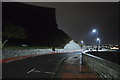
(The easiest way to find it is to walk [or drive] up from the Barbican end of the Hoe, along the waterside. The little monument is close to a notorious 'tomb-stoning' spot, and usually there are ice cream vans nearby, so as well as seeing the stone you can tuck in to a welcome cooling ice while watching daredevils jumping into the sea! There were no tomb-stoners on a very hot Bank Holiday Monday, 28.8.17, when I also visited the beautiful poppies exhibition on top of the Hoe. They're a travelling exhibition from the Tower of London display, and are there til 19th Nov.)
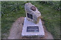
The inscription on the plaque reads:
"1815 - 2015
Napoleon, Emperor of the French, was detained on HMS Bellerophon in Plymouth Sound from 26 July to 4 August 1815. Large crowds came to catch a glimpse of him.
These two blocks of granite are from Dartmoor Prison, where thousands of French prisoners were held captive during the Napoleonic Wars. Embedded is a volcanic stone from Longwood House, St Helena, where Napoleon died on 5 May 1821.
The stones stand here to celebrate 200 years of peace between the United Kingdom and France."
You may be viewing yesterday's version of this page. To see the most up to date information please register for a free account.
")
")
Do not use the above information on other web sites or publications without permission of the contributor.
Nearby Images from Geograph Britain and Ireland:
©2016(licence)

©2017(licence)
©2018(licence)
©2018(licence)
©2017(licence)
The above images may not be of the site on this page, they are loaded from Geograph.
Please Submit an Image of this site or go out and take one for us!
Click here to see more info for this site
Nearby sites
Key: Red: member's photo, Blue: 3rd party photo, Yellow: other image, Green: no photo - please go there and take one, Grey: site destroyed
Download sites to:
KML (Google Earth)
GPX (GPS waypoints)
CSV (Garmin/Navman)
CSV (Excel)
To unlock full downloads you need to sign up as a Contributory Member. Otherwise downloads are limited to 50 sites.
Turn off the page maps and other distractions
Nearby sites listing. In the following links * = Image available
609m WNW 290° Plymouth Giants Hill Figure or Geoglyph (SX475539)
841m ESE 123° Mount Batten Ancient Mine, Quarry or other Industry (SX4876053196)
927m E 87° Cattedown Bone Cave Cave or Rock Shelter (SX490537)
3.3km ESE 106° Burrow Hill Round Barrow(s) (SX512527)
3.3km WSW 249° Mount Edgecombe Barrow* Round Barrow(s) (SX4495052600)
3.7km WSW 243° St Julian's Well (Maker)* Holy Well or Sacred Spring (SX447521)
4.5km E 87° Elburton Burial Mound Round Barrow(s) (SX526538)
5.0km E 96° Elburton Cross* Ancient Cross (SX5304952984)
8.0km SW 230° Garry Wells* Holy Well or Sacred Spring (SX418487)
8.3km SW 227° Rame Head* Hillfort (SX41804825)
8.7km NE 45° Boringdon Camp* Hillfort (SX544596)
8.7km WNW 299° Trehan Cross* Ancient Cross (SX405581)
9.3km E 86° Wasteberry Camp Hillfort (SX5738854066)
10.7km NNE 13° Third Roborough Down Earthworks* Misc. Earthwork (SX5077364013)
10.7km W 275° Lady Well (Shevlock)* Holy Well or Sacred Spring (SX37425488)
10.7km NW 314° St Mary the Virgin (Cornwall)* Holy Well or Sacred Spring (SX4055461327)
10.7km NNE 13° Second Roborough Down Earthworks* Hillfort (SX50736407)
10.8km NNE 12° Roborough Down Earthworks* Hillfort (SX50556415)
10.9km NW 311° Holy Well near Saltash Holy Well or Sacred Spring (SX400610)
11.3km NE 39° Shaugh Moor South Stone Circle (SX554623)
11.4km NE 41° Collard Tor circle Stone Circle (SX5584062030)
11.4km NE 41° Collard Tor W* Stone Row / Alignment (SX5583362045)
11.4km NE 41° Collard Tor E* Stone Row / Alignment (SX55856204)
11.4km NE 38° Hawk's Tor (Shaugh Moor) Cave or Rock Shelter (SX55396250)
11.5km NE 53° Crownhill Down Cairn Circle* Cairn (SX57486026)
View more nearby sites and additional images


 We would like to know more about this location. Please feel free to add a brief description and any relevant information in your own language.
 Wir möchten mehr über diese Stätte erfahren. Bitte zögern Sie nicht, eine kurze Beschreibung und relevante Informationen in Deutsch hinzuzufügen.
 Nous aimerions en savoir encore un peu sur les lieux. S'il vous plaît n'hesitez pas à ajouter une courte description et tous les renseignements pertinents dans votre propre langue.
 Quisieramos informarnos un poco más de las lugares. No dude en añadir una breve descripción y otros datos relevantes en su propio idioma.