


<< Text Pages >> Gibbett Hill - Ring Cairn in England in Devon
Submitted by Anne T on Tuesday, 25 October 2016 Page Views: 1378
Neolithic and Bronze AgeSite Name: Gibbett Hill Alternative Name: Grinsell Mary Tavy 1; Turner A15Country: England
NOTE: This site is 1.775 km away from the location you searched for.
County: Devon Type: Ring Cairn
Nearest Town: Tavistock Nearest Village: Blackdown
Map Ref: SX49958084
Latitude: 50.607929N Longitude: 4.121962W
Condition:
| 5 | Perfect |
| 4 | Almost Perfect |
| 3 | Reasonable but with some damage |
| 2 | Ruined but still recognisable as an ancient site |
| 1 | Pretty much destroyed, possibly visible as crop marks |
| 0 | No data. |
| -1 | Completely destroyed |
| 5 | Superb |
| 4 | Good |
| 3 | Ordinary |
| 2 | Not Good |
| 1 | Awful |
| 0 | No data. |
| 5 | Can be driven to, probably with disabled access |
| 4 | Short walk on a footpath |
| 3 | Requiring a bit more of a walk |
| 2 | A long walk |
| 1 | In the middle of nowhere, a nightmare to find |
| 0 | No data. |
| 5 | co-ordinates taken by GPS or official recorded co-ordinates |
| 4 | co-ordinates scaled from a detailed map |
| 3 | co-ordinates scaled from a bad map |
| 2 | co-ordinates of the nearest village |
| 1 | co-ordinates of the nearest town |
| 0 | no data |
Be the first person to rate this site - see the 'Contribute!' box in the right hand menu.
Internal Links:
External Links:
Ring Cairn in Devon
Information about the Gibbet Hill Stone Ring Cairn Circle comes from the Prehistoric Dartmoor Walks (PDW) website. Their notes tell us this is a "stone ring measuring 10.8 meters in diameter internally with bank 1.7 metres wide and 0.4 meters high."
The PDW web page gives links to further information on Pastscape, Monument Number 438145, which adds that this is "the remains of a cairn ... truncated cairn or, less probably, a ring cairn, sited on hill spur. Diameter 17.5 metres." Although the grid references are the same, the dimensions given vary between records.
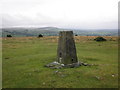
The Heritage Gateway for Devon & Dartmoor MDV22751 (Ring Cairn on Gibbet Hill, Mary Tavy) dates the cairn from the Early Neolithic to the Late Bronze Age (4000BC to 701BC). They add that the cairn: "This ring cairn lies around 20 metres west of the trig point. The cairn has a disturbed ring bank and measures about 18 metres in diameter".
Note: PDW tells us: "(This site is) duplicated in HER see 3202 and MDV3202 (Ring Cairn on Gibbet Hill).
Note: Have you visited this site? Do you have any photographs, images or further information you can add?
You may be viewing yesterday's version of this page. To see the most up to date information please register for a free account.
Do not use the above information on other web sites or publications without permission of the contributor.
Nearby Images from Geograph Britain and Ireland:
©2010(licence)
©2009(licence)
©2019(licence)
©2010(licence)
©2009(licence)
The above images may not be of the site on this page, they are loaded from Geograph.
Please Submit an Image of this site or go out and take one for us!
Click here to see more info for this site
Nearby sites
Key: Red: member's photo, Blue: 3rd party photo, Yellow: other image, Green: no photo - please go there and take one, Grey: site destroyed
Download sites to:
KML (Google Earth)
GPX (GPS waypoints)
CSV (Garmin/Navman)
CSV (Excel)
To unlock full downloads you need to sign up as a Contributory Member. Otherwise downloads are limited to 50 sites.
Turn off the page maps and other distractions
Nearby sites listing. In the following links * = Image available
1.9km WNW 287° North Brentor Well* Holy Well or Sacred Spring (SX4813881440)
2.9km W 259° Brent Tor* Hillfort (SX4709780392)
3.0km NE 45° Ring of Bells* Ring Cairn (SX5214082873)
3.4km SSE 155° Peter Tavy Churchyard Cross* Ancient Cross (SX51307770)
4.1km NE 45° White Hill South* Ring Cairn (SX5294283680)
4.2km ESE 115° Cudlipptown Down Cairn (SX5373278949)
4.3km ESE 121° Cudliptown Down Enclosed Settlement* Ancient Village or Settlement (SX536785)
4.6km ENE 62° Nattor Down 5 Cairn (SX54098286)
4.7km NE 47° White Hill North Cairn Field Ring Cairn (SX53528395)
4.8km ESE 120° White Tor Long Cairn* Cairn (SX5401478316)
4.8km ESE 115° White Tor (Peter Tavy)* Ancient Village or Settlement (SX5424078673)
4.8km E 82° Standon Hill Cairn Cairn (SX5473781373)
5.0km ESE 118° South of White Tor Cairns* Barrow Cemetery (SX543784)
5.0km NE 47° White Hill North East* Cairn (SX5371384190)
5.1km ESE 113° Cairns East of White Tor* Cairn (SX5459578695)
5.1km ESE 114° East of White for cairn 2* Cairn (SX5459278664)
5.1km ESE 113° East of White Tor cairn 3* Cairn (SX5461278668)
5.2km ESE 113° East of White Tor Cairn 4* Cist (SX5469478690)
5.3km ENE 60° Ger Tor Cairn (SX54658338)
5.4km ESE 111° Langstone Moor row 2* Stone Row / Alignment (SX54957880)
5.4km SE 130° Roos Tor north west* Ancient Village or Settlement (SX5403977254)
5.4km ESE 110° Langstone Moor stone row* Stone Row / Alignment (SX5502278851)
5.5km ESE 111° The Langstone* Standing Stone (Menhir) (SX55027873)
5.5km ESE 110° Langstone Moor 3 Stone Row / Alignment (SX55107880)
5.6km SE 124° Wedlake Cairns* Barrow Cemetery (SX545776)
View more nearby sites and additional images


 We would like to know more about this location. Please feel free to add a brief description and any relevant information in your own language.
 Wir möchten mehr über diese Stätte erfahren. Bitte zögern Sie nicht, eine kurze Beschreibung und relevante Informationen in Deutsch hinzuzufügen.
 Nous aimerions en savoir encore un peu sur les lieux. S'il vous plaît n'hesitez pas à ajouter une courte description et tous les renseignements pertinents dans votre propre langue.
 Quisieramos informarnos un poco más de las lugares. No dude en añadir una breve descripción y otros datos relevantes en su propio idioma.