 with our Megalithic Portal iPhone app")

<< Text Pages >> Allée couverte de Lia - Passage Grave in France in Bretagne:Finistère (29)
Submitted by holger_rix on Sunday, 10 January 2016 Page Views: 1093
Neolithic and Bronze AgeSite Name: Allée couverte de LiaCountry: France
NOTE: This site is 1.953 km away from the location you searched for.
Département: Bretagne:Finistère (29) Type: Passage Grave
Nearest Town: Morlaix Nearest Village: Sibiril
Latitude: 48.672433N Longitude: 4.077371W
Condition:
| 5 | Perfect |
| 4 | Almost Perfect |
| 3 | Reasonable but with some damage |
| 2 | Ruined but still recognisable as an ancient site |
| 1 | Pretty much destroyed, possibly visible as crop marks |
| 0 | No data. |
| -1 | Completely destroyed |
| 5 | Superb |
| 4 | Good |
| 3 | Ordinary |
| 2 | Not Good |
| 1 | Awful |
| 0 | No data. |
| 5 | Can be driven to, probably with disabled access |
| 4 | Short walk on a footpath |
| 3 | Requiring a bit more of a walk |
| 2 | A long walk |
| 1 | In the middle of nowhere, a nightmare to find |
| 0 | No data. |
| 5 | co-ordinates taken by GPS or official recorded co-ordinates |
| 4 | co-ordinates scaled from a detailed map |
| 3 | co-ordinates scaled from a bad map |
| 2 | co-ordinates of the nearest village |
| 1 | co-ordinates of the nearest town |
| 0 | no data |
Be the first person to rate this site - see the 'Contribute!' box in the right hand menu.
Internal Links:
External Links:
Passage Grave in Bretagne:Finistère (29)
Sibiril, Morlaix, Finistère, Brittany
Source: T4T35.fr
You may be viewing yesterday's version of this page. To see the most up to date information please register for a free account.
Do not use the above information on other web sites or publications without permission of the contributor.
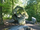
Nearby Images from Flickr
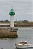
The above images may not be of the site on this page, but were taken nearby. They are loaded from Flickr so please click on them for image credits.
Click here to see more info for this site
Nearby sites
Click here to view sites on an interactive map of the areaKey: Red: member's photo, Blue: 3rd party photo, Yellow: other image, Green: no photo - please go there and take one, Grey: site destroyed
Download sites to:
KML (Google Earth)
GPX (GPS waypoints)
CSV (Garmin/Navman)
CSV (Excel)
To unlock full downloads you need to sign up as a Contributory Member. Otherwise downloads are limited to 50 sites.
Turn off the page maps and other distractions
Nearby sites listing. In the following links * = Image available
1.6km SSE 164° Menhir de Keringar* Standing Stone (Menhir)
1.8km NE 34° Dolmen de Tévenn Burial Chamber or Dolmen
2.2km NNW 331° Affleurement à Cupules de Creach al Lia Rock Art
4.8km WSW 255° Kerider stèle* Standing Stone (Menhir)
5.2km NE 55° Dalle à Cupules de Mean Diante Rock Art
5.7km W 273° Menhir de Kergallec Standing Stone (Menhir)
6.1km WSW 254° Créac’h-ar-Vrenn* Passage Grave
6.2km WSW 254° Couinandré Menhir* Standing Stone (Menhir)
6.4km W 277° Menhir d'Irvit* Standing Stone (Menhir)
6.8km E 79° St Pol-de-Léon mégalithes disparu Standing Stone (Menhir)
7.9km W 281° Menhir de Kergoarat* Standing Stone (Menhir)
8.4km W 278° Grand menhir de Saint-Eden* Standing Stone (Menhir)
8.8km ESE 101° Kerivin Dolmen* Burial Chamber or Dolmen
9.2km W 263° Prat Meur menhir* Standing Stone (Menhir)
9.7km W 267° Porz Ar Stréat menhir* Standing Stone (Menhir)
9.7km NE 40° Dolmen du Jardin Botanique* Burial Chamber or Dolmen
9.7km NE 37° Menhir de Kreach ar Bolloch 1 Standing Stone (Menhir)
9.7km NE 40° Nécropole du Jardin Botanique* Barrow Cemetery
9.7km NE 37° Menhir de Kreach ar Bolloch 2 Standing Stone (Menhir)
10.3km W 260° Guinivrit* Passage Grave
10.9km WSW 255° Menhir de Kernic Standing Stone (Menhir)
11.2km SW 229° Landeguiarc'h menhir Standing Stone (Menhir)
11.4km WSW 251° Calvaire de Menez-ar-Plour Standing Stone (Menhir)
11.7km WSW 238° Parc Ar est menhir Standing Stone (Menhir)
11.7km WSW 238° Parc Ar ouest menhir Standing Stone (Menhir)
View more nearby sites and additional images


 We would like to know more about this location. Please feel free to add a brief description and any relevant information in your own language.
 Wir möchten mehr über diese Stätte erfahren. Bitte zögern Sie nicht, eine kurze Beschreibung und relevante Informationen in Deutsch hinzuzufügen.
 Nous aimerions en savoir encore un peu sur les lieux. S'il vous plaît n'hesitez pas à ajouter une courte description et tous les renseignements pertinents dans votre propre langue.
 Quisieramos informarnos un poco más de las lugares. No dude en añadir una breve descripción y otros datos relevantes en su propio idioma.