


<< Our Photo Pages >> Pen Y Gaer (Bethesda) - Hillfort in Wales in Gwynedd
Submitted by coldrum on Monday, 19 January 2009 Page Views: 4674
Iron Age and Later PrehistorySite Name: Pen Y Gaer (Bethesda)Country: Wales
NOTE: This site is 0.621 km away from the location you searched for.
County: Gwynedd Type: Hillfort
Nearest Village: Talgarreg
Map Ref: SH62826725
Latitude: 53.184606N Longitude: 4.054381W
Condition:
| 5 | Perfect |
| 4 | Almost Perfect |
| 3 | Reasonable but with some damage |
| 2 | Ruined but still recognisable as an ancient site |
| 1 | Pretty much destroyed, possibly visible as crop marks |
| 0 | No data. |
| -1 | Completely destroyed |
| 5 | Superb |
| 4 | Good |
| 3 | Ordinary |
| 2 | Not Good |
| 1 | Awful |
| 0 | No data. |
| 5 | Can be driven to, probably with disabled access |
| 4 | Short walk on a footpath |
| 3 | Requiring a bit more of a walk |
| 2 | A long walk |
| 1 | In the middle of nowhere, a nightmare to find |
| 0 | No data. |
| 5 | co-ordinates taken by GPS or official recorded co-ordinates |
| 4 | co-ordinates scaled from a detailed map |
| 3 | co-ordinates scaled from a bad map |
| 2 | co-ordinates of the nearest village |
| 1 | co-ordinates of the nearest town |
| 0 | no data |
Be the first person to rate this site - see the 'Contribute!' box in the right hand menu.
Internal Links:
External Links:
 (PID:95510)")
Iron age, oval earthwork enclosure.
RCAHMW (Coflein) website page.
You may be viewing yesterday's version of this page. To see the most up to date information please register for a free account.
Do not use the above information on other web sites or publications without permission of the contributor.
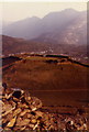
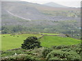
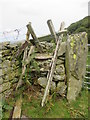
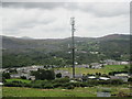
Nearby Images from Geograph Britain and Ireland:
©2010(licence)
©2017(licence)
©2017(licence)
©2017(licence)
©2024(licence)
The above images may not be of the site on this page, they are loaded from Geograph.
Please Submit an Image of this site or go out and take one for us!
Click here to see more info for this site
Nearby sites
Key: Red: member's photo, Blue: 3rd party photo, Yellow: other image, Green: no photo - please go there and take one, Grey: site destroyed
Download sites to:
KML (Google Earth)
GPX (GPS waypoints)
CSV (Garmin/Navman)
CSV (Excel)
To unlock full downloads you need to sign up as a Contributory Member. Otherwise downloads are limited to 50 sites.
Turn off the page maps and other distractions
Nearby sites listing. In the following links * = Image available
1m E 90° Pen y Gaer* Hillfort (SH62826725)
650m N 358° Fortified hut settlement above Rachub* Hillfort (SH62826790)
719m NNE 26° Cairn cemetery, W. shoulder of Moel Faban* Cairn (SH63156789)
928m NE 52° Moel Faban Arrow Stone* Carving (SH63576780)
1.1km NE 36° Moel Faban* Cairn (SH63486811)
1.1km NW 311° Maes Bleddyn Hut Circle Settlement* Ancient Village or Settlement (SH6200768009)
1.4km NE 38° Bwlch ym Mhwll-le* Cairn (SH63746835)
2.0km NE 38° Hut Circle at Twll Pant Hiriol* Ancient Village or Settlement (SH641688)
2.3km W 261° Sling (Llandegai)* Chambered Tomb (SH60556695)
2.3km NNW 330° Rhiw Goch Enclosed Hut Circle Settlement* Ancient Village or Settlement (SH61696931)
3.0km WNW 302° Pen Dinas Camp* Hillfort (SH603689)
3.3km NE 39° Moel Wnion (Gwynedd)* Cairn (SH64966971)
3.5km ENE 76° Drosgl* Cairn (SH663680)
3.9km WSW 251° Carnedd Moel Y Ci* Round Cairn (SH591661)
4.2km NNE 33° Cairn N of Moel Wnion* Cairn (SH65197071)
4.2km WSW 252° Ty'n Llidiard Hut Circle Settlement* Ancient Village or Settlement (SH5873066090)
4.4km NNE 34° Cras (Gwynedd)* Cairn (SH65397089)
4.7km NW 321° Llandegai Bronze Age Settlement* Ancient Village or Settlement (SH600710)
4.9km NW 319° Llandegai Cursus Cursus (SH597710)
5.0km NE 50° Coed Aber Roundhouse* Ancient Village or Settlement (SH6674570381)
5.1km NW 316° Llandegai Cursus* Cursus (SH594710)
5.1km NW 316° Llandegai Henge Complex* Henge (SH59407100)
5.4km SE 141° Cairn SW of Carnedd Dafydd* Cairn (SH66136293)
5.4km SE 141° Carnedd Dafydd (Conwy)* Cairn (SH661629)
5.5km SE 146° Carnedd Fach* Cairn (SH6580062620)
View more nearby sites and additional images


 We would like to know more about this location. Please feel free to add a brief description and any relevant information in your own language.
 Wir möchten mehr über diese Stätte erfahren. Bitte zögern Sie nicht, eine kurze Beschreibung und relevante Informationen in Deutsch hinzuzufügen.
 Nous aimerions en savoir encore un peu sur les lieux. S'il vous plaît n'hesitez pas à ajouter une courte description et tous les renseignements pertinents dans votre propre langue.
 Quisieramos informarnos un poco más de las lugares. No dude en añadir una breve descripción y otros datos relevantes en su propio idioma.