

<< Our Photo Pages >> Castell Flemish - Hillfort in Wales in Ceredigion
Submitted by postman on Saturday, 10 January 2015 Page Views: 2298
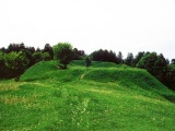
Iron Age and Later PrehistorySite Name: Castell Flemish Alternative Name: Vuarth Caraun Buarth CaronCountry: Wales
NOTE: This site is 1.855 km away from the location you searched for.
County: Ceredigion Type: Hillfort
Nearest Town: Lampeter Nearest Village: Tyn'reithin
Map Ref: SN6538863195
Latitude: 52.250417N Longitude: 3.97331W
Condition:
| 5 | Perfect |
| 4 | Almost Perfect |
| 3 | Reasonable but with some damage |
| 2 | Ruined but still recognisable as an ancient site |
| 1 | Pretty much destroyed, possibly visible as crop marks |
| 0 | No data. |
| -1 | Completely destroyed |
| 5 | Superb |
| 4 | Good |
| 3 | Ordinary |
| 2 | Not Good |
| 1 | Awful |
| 0 | No data. |
| 5 | Can be driven to, probably with disabled access |
| 4 | Short walk on a footpath |
| 3 | Requiring a bit more of a walk |
| 2 | A long walk |
| 1 | In the middle of nowhere, a nightmare to find |
| 0 | No data. |
| 5 | co-ordinates taken by GPS or official recorded co-ordinates |
| 4 | co-ordinates scaled from a detailed map |
| 3 | co-ordinates scaled from a bad map |
| 2 | co-ordinates of the nearest village |
| 1 | co-ordinates of the nearest town |
| 0 | no data |
Internal Links:
External Links:
I have visited· I would like to visit
SolarMegalith would like to visit
")
I parked in the small lay-by off the A485 about fifty yards east from the hill fort, sadly it was chucking it down so we waterproofed up and splashed back up the road. I didn't ask for permission to get in, I do, sometimes, but it was early, raining and misty so instead we gracefully leaped the barbed wire fence, well, as graceful as wellied feet can any way, it's only a short stroll from the fence, in fact the forts most extreme northern defences seem to be cut into by the road side embankment.
I wondered, then doubted whether any Dutch speaking Belgians had ever lived here, surely they would have been native Welsh iron age folk like anywhere in the country.
We started our circuit of the forts defences, noting at least two entrances east and south west. As we passed by the south western gate I wondered if on a clear day we could see Sunnyhill camp the other side of Tregaron about three miles distant.
This is the first of three hill forts that are just on the way to where we're going.
Just on the way, sadly, a longer visit with a football, kite or other child friendly activity would be better I know.
You may be viewing yesterday's version of this page. To see the most up to date information please register for a free account.
")
")
")
")
")
")
")
Do not use the above information on other web sites or publications without permission of the contributor.
Click here to see more info for this site
Nearby sites
Key: Red: member's photo, Blue: 3rd party photo, Yellow: other image, Green: no photo - please go there and take one, Grey: site destroyed
Download sites to:
KML (Google Earth)
GPX (GPS waypoints)
CSV (Garmin/Navman)
CSV (Excel)
To unlock full downloads you need to sign up as a Contributory Member. Otherwise downloads are limited to 50 sites.
Turn off the page maps and other distractions
Nearby sites listing. In the following links * = Image available
2.7km SSW 209° Pen-Y-Gaer (Llangeitho) Hillfort (SN63996083)
4.1km SE 138° Tregaron Gorsedd Circle* Modern Stone Circle etc (SN6807860037)
4.4km NNE 26° St Ffraid's Well* Holy Well or Sacred Spring (SN67436705)
4.5km SE 131° Castell Tregaron* Hillfort (SN6869760188)
5.8km NNW 334° Ty n-yr-eithin* Cairn (SN630685)
7.0km NNE 25° Llanwnnws Inscribed Stone Early Christian Sculptured Stone (SN68516950)
7.8km NE 43° Pen y Ffrwd* Hillfort (SN709688)
7.9km S 171° St David (Llandewi Brefi)* Ancient Cross (SN66385531)
8.0km NE 34° Garreg Lwyd Ancient Village or Settlement (SN70106972)
8.0km ESE 113° Groes Fawr Cairn* Round Cairn (SN7273059860)
8.5km ESE 112° Castell Rhyfel Hillfort (SN7320059870)
8.6km NNE 31° Nant Byr Isaf Cairn (SN70037044)
8.6km N 355° Gaer Fawr (Lledrod)* Hillfort (SN648718)
9.1km SW 236° Pen-Y-Gaer (Nantcwnlle)* Hillfort (SN57735833)
9.2km NW 321° The Dominicus Stone Early Christian Sculptured Stone (SN597705)
9.5km NE 40° Banc-Y-Geufron* Cairn (SN71637033)
9.5km ENE 66° Pen-y-Bannau* Hillfort (SN74196689)
9.6km ENE 73° Strata Florida Sculptured Stone* Early Christian Sculptured Stone (SN74646577)
9.6km SSE 165° Careg Samson* Standing Stone (Menhir) (SN67575384)
10.2km S 170° Crug cairn* Cairn (SN66855311)
10.4km E 79° Ffynnon Llygaid (Drefach)* Holy Well or Sacred Spring (SN7564064940)
10.6km E 84° Glasffrwyd Holy Well* Holy Well or Sacred Spring (SN75996399)
10.6km ESE 112° Blaen Camddwr Cairn* Cairn (SN7516558906)
11.2km W 277° Llech Gron* Standing Stone (Menhir) (SN5424664851)
11.3km NNE 15° Coed Ty'n y Cwm* Hillfort (SN687740)
View more nearby sites and additional images


 We would like to know more about this location. Please feel free to add a brief description and any relevant information in your own language.
 Wir möchten mehr über diese Stätte erfahren. Bitte zögern Sie nicht, eine kurze Beschreibung und relevante Informationen in Deutsch hinzuzufügen.
 Nous aimerions en savoir encore un peu sur les lieux. S'il vous plaît n'hesitez pas à ajouter une courte description et tous les renseignements pertinents dans votre propre langue.
 Quisieramos informarnos un poco más de las lugares. No dude en añadir una breve descripción y otros datos relevantes en su propio idioma.