


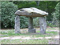
<< Other Photo Pages >> Delamore House dolmen - Modern Stone Circle etc in England in Devon
Submitted by AngieLake on Friday, 22 May 2015 Page Views: 4456
Modern SitesSite Name: Delamore House dolmenCountry: England
NOTE: This site is 0.897 km away from the location you searched for.
County: Devon Type: Modern Stone Circle etc
Nearest Town: Ivybridge Nearest Village: Cornwood
Map Ref: SX5991760112
Latitude: 50.424114N Longitude: 3.973408W
Condition:
| 5 | Perfect |
| 4 | Almost Perfect |
| 3 | Reasonable but with some damage |
| 2 | Ruined but still recognisable as an ancient site |
| 1 | Pretty much destroyed, possibly visible as crop marks |
| 0 | No data. |
| -1 | Completely destroyed |
| 5 | Superb |
| 4 | Good |
| 3 | Ordinary |
| 2 | Not Good |
| 1 | Awful |
| 0 | No data. |
| 5 | Can be driven to, probably with disabled access |
| 4 | Short walk on a footpath |
| 3 | Requiring a bit more of a walk |
| 2 | A long walk |
| 1 | In the middle of nowhere, a nightmare to find |
| 0 | No data. |
| 5 | co-ordinates taken by GPS or official recorded co-ordinates |
| 4 | co-ordinates scaled from a detailed map |
| 3 | co-ordinates scaled from a bad map |
| 2 | co-ordinates of the nearest village |
| 1 | co-ordinates of the nearest town |
| 0 | no data |
Internal Links:
External Links:
I have visited· I would like to visit
janetbrady would like to visit
Andy B has visited here
")
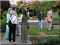
While checking out the website for the house (which uses the dolmen as a logo), I found a photo of it: http://www.delamore-art.co.uk/gardens.php
... and then found a link to this 'panoramio' page by Guy Fogwill of Kingsteignton:
http://www.panoramio.com/photo/106518610
Mr Fogwill describes the dolmen as being constructed for the Millennium. It reminds me of Spinsters Rock.
Quote from their website:
"Delamore Arts 2015 is now open to visitors...
The exhibition is open every day in May, 1030 to 1630. Fantastic art and sculpture in an amazing garden and house. This year also features a woodland musical art trail, and an animal themed exhibition in the new gallery at Delamore Park a short walk across the valley. Admission at £7.50 includes a superb catalogue and keepsake of the exhibition."
I imagine you'd get to see the dolmen during such a visit.
You may be viewing yesterday's version of this page. To see the most up to date information please register for a free account.
Do not use the above information on other web sites or publications without permission of the contributor.
Nearby Images from Geograph Britain and Ireland:
©2006(licence)
©2006(licence)
©2014(licence)
©2014(licence)
©2023(licence)
The above images may not be of the site on this page, they are loaded from Geograph.
Please Submit an Image of this site or go out and take one for us!
Click here to see more info for this site
Nearby sites
Key: Red: member's photo, Blue: 3rd party photo, Yellow: other image, Green: no photo - please go there and take one, Grey: site destroyed
Download sites to:
KML (Google Earth)
GPX (GPS waypoints)
CSV (Garmin/Navman)
CSV (Excel)
To unlock full downloads you need to sign up as a Contributory Member. Otherwise downloads are limited to 50 sites.
Turn off the page maps and other distractions
Nearby sites listing. In the following links * = Image available
1.8km NE 43° Rook Tor Ring Cairn (SX612614)
2.1km N 356° Penn Beacon Platform Cairn Circle Cairn (SX59826225)
2.4km N 349° Penn Beacon SW* Multiple Stone Rows / Avenue (SX5952062471)
2.4km N 349° Penn Beacon 1 Cairn Circle & Cist* Cairn (SX5953262482)
2.4km N 359° Penn Beacon SE* Stone Row / Alignment (SX5994762546)
2.4km W 272° Crownhill Down Cairn Circle* Cairn (SX57486026)
2.6km NW 324° Cholwich Town Cairn Circle* Stone Circle (SX58466225)
2.6km N 356° Penn Beacon NE Stone Row / Alignment (SX598627)
2.6km NW 326° Cholwichtown stone row* Stone Row / Alignment (SX585623)
2.7km N 11° High-house Waste Ancient Village or Settlement (SX60506270)
2.7km N 359° Penn Moor Reave West Misc. Earthwork (SX59956282)
2.8km N 6° Penn Moor Reave East Misc. Earthwork (SX60306289)
2.8km N 358° Penn Beacon Cairn* Cairn (SX59916292)
3.1km N 350° Shell Top South-West stone row* Stone Row / Alignment (SX59466315)
3.1km NNE 29° Dendles Waste* Cairn (SX61536279)
3.4km N 349° Shell Top South West* Ancient Village or Settlement (SX59386344)
3.4km NNW 336° Lee Moor Settlement* Ancient Village or Settlement (SX586633)
3.6km NE 43° Harrowthorn* Cairn (SX6244662645)
3.6km NNW 338° Shell Top Chambered Cairn* Cairn (SX58666349)
3.6km ENE 62° Stalldown Southern Terminal Cairn Circle* Cairn (SX6317661737)
3.7km NE 52° Stalldown West* Cist (SX6284462309)
3.7km N 356° Shell Top Platform Cairn Circle Cairn (SX5976163799)
3.7km N 357° Shell Top Cairn Circle Ring Cairn (SX5983063830)
3.7km ENE 61° Stalldown Stone Row Cairn S* Cairn (SX63226186)
3.8km E 88° Burford Down Stone Row* Stone Row / Alignment (SX63696016)
View more nearby sites and additional images


 We would like to know more about this location. Please feel free to add a brief description and any relevant information in your own language.
 Wir möchten mehr über diese Stätte erfahren. Bitte zögern Sie nicht, eine kurze Beschreibung und relevante Informationen in Deutsch hinzuzufügen.
 Nous aimerions en savoir encore un peu sur les lieux. S'il vous plaît n'hesitez pas à ajouter une courte description et tous les renseignements pertinents dans votre propre langue.
 Quisieramos informarnos un poco más de las lugares. No dude en añadir una breve descripción y otros datos relevantes en su propio idioma.