 with our Megalithic Portal iPhone app")


<< Our Photo Pages >> Feranach - Broch or Nuraghe in Scotland in Sutherland
Submitted by SolarMegalith on Tuesday, 15 November 2011 Page Views: 3903
Iron Age and Later PrehistorySite Name: FeranachCountry: Scotland
NOTE: This site is 3.598 km away from the location you searched for.
County: Sutherland Type: Broch or Nuraghe
Nearest Village: Kildonan
Map Ref: NC84412730
Latitude: 58.219250N Longitude: 3.96938W
Condition:
| 5 | Perfect |
| 4 | Almost Perfect |
| 3 | Reasonable but with some damage |
| 2 | Ruined but still recognisable as an ancient site |
| 1 | Pretty much destroyed, possibly visible as crop marks |
| 0 | No data. |
| -1 | Completely destroyed |
| 5 | Superb |
| 4 | Good |
| 3 | Ordinary |
| 2 | Not Good |
| 1 | Awful |
| 0 | No data. |
| 5 | Can be driven to, probably with disabled access |
| 4 | Short walk on a footpath |
| 3 | Requiring a bit more of a walk |
| 2 | A long walk |
| 1 | In the middle of nowhere, a nightmare to find |
| 0 | No data. |
| 5 | co-ordinates taken by GPS or official recorded co-ordinates |
| 4 | co-ordinates scaled from a detailed map |
| 3 | co-ordinates scaled from a bad map |
| 2 | co-ordinates of the nearest village |
| 1 | co-ordinates of the nearest town |
| 0 | no data |
Internal Links:
External Links:
")
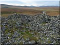
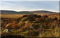
Ruins of Feranach broch are located near Kildonan, two miles from River Helmsdale. The broch is in good condition, it has an entrance opened to the west followed by the passage which is up to 1,19 m wide. The main chamber has five intra-mural cells, largest of which can be classified as a gallery. The guard cell is of 1,83 x 1,53 m dimensions. There are no visible remains of outbuildings around the broch.
MacKie E.W. 2007. The Roundhouses, Brochs and Wheelhouses of Atlantic Scotland c. 700 BC – AD 500. Part 2 (I). Oxford: Archaeopress (p. 646).
You may be viewing yesterday's version of this page. To see the most up to date information please register for a free account.
Do not use the above information on other web sites or publications without permission of the contributor.
Nearby Images from Geograph Britain and Ireland:
©2017(licence)
©2014(licence)
©2014(licence)
©2017(licence)
©2015(licence)
The above images may not be of the site on this page, they are loaded from Geograph.
Please Submit an Image of this site or go out and take one for us!
Click here to see more info for this site
Nearby sites
Key: Red: member's photo, Blue: 3rd party photo, Yellow: other image, Green: no photo - please go there and take one, Grey: site destroyed
Download sites to:
KML (Google Earth)
GPX (GPS waypoints)
CSV (Garmin/Navman)
CSV (Excel)
To unlock full downloads you need to sign up as a Contributory Member. Otherwise downloads are limited to 50 sites.
Turn off the page maps and other distractions
Nearby sites listing. In the following links * = Image available
3.2km NE 49° Kinbrace Hill 2* Chambered Cairn (NC86882935)
3.3km ENE 71° Kinbrace Burn* Chambered Cairn (NC87572830)
3.3km NE 54° Kinbrace Hill 1* Cairn (NC87172915)
3.6km WSW 248° Altanduin Broch or Nuraghe (NC80972605)
4.2km NNE 28° Creag Nan Caorach Hut Circles* Ancient Village or Settlement (NC865310)
4.4km NNE 31° Creag Nan Caorach Cairn Cairn (NC868310)
4.4km NE 34° Creag Nan Caorach Chambered Cairn* Chambered Cairn (NC870309)
4.8km ESE 113° Suisgill Broch* Broch or Nuraghe (NC88752530)
5.0km NNE 25° Creag Nan Caorach Hut Circles* Ancient Village or Settlement (NC867318)
5.1km NNW 339° Kinbrace Stone Rows* Multiple Stone Rows / Avenue (NC8273332160)
5.2km ESE 113° Suisgill Souterrian* Souterrain (Fogou, Earth House) (NC89172511)
5.9km ESE 111° Carn Nam Buth* Broch or Nuraghe (NC89892498)
6.0km ESE 121° Learable Hill N* Stone Circle (NC895241)
6.1km SE 127° Learable Hill S* Stone Circle (NC89162351)
6.1km SE 126° Learable Hill Row 1* Stone Row / Alignment (NC8920923546)
6.1km SE 127° Learable Hill Row 2* Stone Row / Alignment (NC8920523530)
6.1km SE 126° Learable Hill* Multiple Stone Rows / Avenue (NC8925123550)
6.1km SE 127° Learable Hill Cross Incised Stone* Early Christian Sculptured Stone (NC8925723493)
6.2km SE 126° Learable Hill Row 3* Stone Row / Alignment (NC8928123496)
6.2km SE 127° Learable Hill Row 4* Stone Row / Alignment (NC8927423466)
10.0km NW 320° Badanloch* Multiple Stone Rows / Avenue (NC78263516)
11.4km SE 136° Kilearnan Broch* Broch or Nuraghe (NC92161887)
12.0km SE 133° Kilearnan Hill* Broch or Nuraghe (NC92931882)
12.5km NNW 331° Ben Griam Mor Burnt Mound Artificial Mound (NC786384)
12.6km NNW 331° Ben Griam Mor, Hut Circles and Field systems Ancient Village or Settlement (NC786385)
View more nearby sites and additional images


 We would like to know more about this location. Please feel free to add a brief description and any relevant information in your own language.
 Wir möchten mehr über diese Stätte erfahren. Bitte zögern Sie nicht, eine kurze Beschreibung und relevante Informationen in Deutsch hinzuzufügen.
 Nous aimerions en savoir encore un peu sur les lieux. S'il vous plaît n'hesitez pas à ajouter une courte description et tous les renseignements pertinents dans votre propre langue.
 Quisieramos informarnos un poco más de las lugares. No dude en añadir una breve descripción y otros datos relevantes en su propio idioma.