


<< Our Photo Pages >> Gwern Gof Isaf - Ancient Village or Settlement in Wales in Gwynedd
Submitted by Postman on Friday, 05 October 2012 Page Views: 2733
Multi-periodSite Name: Gwern Gof IsafCountry: Wales County: Gwynedd Type: Ancient Village or Settlement
Nearest Town: Bethesda
Map Ref: SH68265971
Latitude: 53.118245N Longitude: 3.969921W
Condition:
| 5 | Perfect |
| 4 | Almost Perfect |
| 3 | Reasonable but with some damage |
| 2 | Ruined but still recognisable as an ancient site |
| 1 | Pretty much destroyed, possibly visible as crop marks |
| 0 | No data. |
| -1 | Completely destroyed |
| 5 | Superb |
| 4 | Good |
| 3 | Ordinary |
| 2 | Not Good |
| 1 | Awful |
| 0 | No data. |
| 5 | Can be driven to, probably with disabled access |
| 4 | Short walk on a footpath |
| 3 | Requiring a bit more of a walk |
| 2 | A long walk |
| 1 | In the middle of nowhere, a nightmare to find |
| 0 | No data. |
| 5 | co-ordinates taken by GPS or official recorded co-ordinates |
| 4 | co-ordinates scaled from a detailed map |
| 3 | co-ordinates scaled from a bad map |
| 2 | co-ordinates of the nearest village |
| 1 | co-ordinates of the nearest town |
| 0 | no data |
Internal Links:
External Links:
I have visited· I would like to visit
Mountainharry visited on 8th Sep 2021 - their rating: Cond: 2 Amb: 5 Access: 3 A small hut circle and possibly more potential building in the surrounds
")
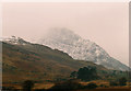
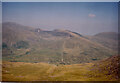
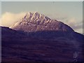
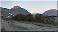
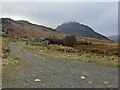
To the east of mother hill and sacred mountain, Tryfan, is a long ridge of rock that runs north to south and parallel to the big pointy mountain. On the other side of the rocky ridge is this well preserved hut circle. Strangely it has an inner circle of stones within, but I've no idea if its original or not (get the team in). Today's weather is mostly mist and drizzle so the awesome views one would expect were hidden from me, but it didn't seem to matter, just being there at all is an intense experience.
You may be viewing yesterday's version of this page. To see the most up to date information please register for a free account.
")
Do not use the above information on other web sites or publications without permission of the contributor.
Nearby Images from Geograph Britain and Ireland:
©2012(licence)
©2021(licence)
©2005(licence)
©2011(licence)
©2022(licence)
The above images may not be of the site on this page, they are loaded from Geograph.
Please Submit an Image of this site or go out and take one for us!
Click here to see more info for this site
Nearby sites
Key: Red: member's photo, Blue: 3rd party photo, Yellow: other image, Green: no photo - please go there and take one, Grey: site destroyed
Download sites to:
KML (Google Earth)
GPX (GPS waypoints)
CSV (Garmin/Navman)
CSV (Excel)
To unlock full downloads you need to sign up as a Contributory Member. Otherwise downloads are limited to 50 sites.
Turn off the page maps and other distractions
Nearby sites listing. In the following links * = Image available
1.4km NE 42° Hut Circle Settlement SE of Glan Llugwy Ancient Village or Settlement (SH69226071)
1.9km WSW 256° Sion a Siân (Adam and Eve) Stones* Natural Stone / Erratic / Other Natural Feature (SH664593)
2.0km SE 128° Nant y Gors Cairn and Cist* Cairn (SH6980458433)
2.0km SE 128° Nant y Gors Hut Circle Settlement* Ancient Village or Settlement (SH6982058413)
2.5km ENE 62° Tal y Braich* Stone Circle (SH705608)
2.5km ENE 63° Tal y Braich Cairn and Standing Stone Cairn (SH70516079)
2.5km W 277° Nant Bochllwyd Hut Circle Settlement* Ancient Village or Settlement (SH6577060100)
3.1km ENE 68° Cairn West of Bwlch Cowlyd* Cairn (SH712608)
3.2km S 173° Dyffryn Mymbyr Round Barrow(s) (SH68565648)
3.2km S 173° Dyffryn Mymbyr* Standing Stone (Menhir) (SH68565648)
3.5km ESE 110° Creigiau'r Gelli Cairn Cairn (SH715584)
3.5km ENE 70° Bwlch Cowlyd Cairn* Cairn (SH716608)
3.5km ENE 69° Bwlch Cowlyd Hut Circles* Ancient Village or Settlement (SH716609)
3.6km ENE 68° Maen Trichwmwd Natural Stone / Erratic / Other Natural Feature (SH7169260962)
3.8km NW 318° Carnedd Fach* Cairn (SH6580062620)
3.8km NW 324° Carnedd Dafydd (Conwy)* Cairn (SH661629)
3.9km NW 325° Cairn SW of Carnedd Dafydd* Cairn (SH66136293)
4.2km NE 50° Pen Llithrig Y Wrach* Cairn (SH71606232)
4.4km ESE 109° Clogwyn Mawr Hut Circle* Ancient Village or Settlement (SH7240058200)
4.6km SW 223° Dyffryn Mymbyr (stone circle)* Stone Circle (SH6505656464)
4.7km N 359° Carnedd Llewelyn* Cairn (SH683644)
5.3km ESE 110° Carnedd Coed Bryn Brethynau* Round Cairn (SH7319057750)
5.4km SSW 195° Nant-y-Llys* Cairn (SH66725450)
5.5km SSE 154° Carnedd Moel Siabod* Cairn (SH70535469)
6.2km N 4° Foel Grach* Cairn (SH68886589)
View more nearby sites and additional images


 We would like to know more about this location. Please feel free to add a brief description and any relevant information in your own language.
 Wir möchten mehr über diese Stätte erfahren. Bitte zögern Sie nicht, eine kurze Beschreibung und relevante Informationen in Deutsch hinzuzufügen.
 Nous aimerions en savoir encore un peu sur les lieux. S'il vous plaît n'hesitez pas à ajouter une courte description et tous les renseignements pertinents dans votre propre langue.
 Quisieramos informarnos un poco más de las lugares. No dude en añadir una breve descripción y otros datos relevantes en su propio idioma.