


<< Text Pages >> Llanwnnws Inscribed Stone - Early Christian Sculptured Stone in Wales in Ceredigion
Submitted by coldrum on Sunday, 12 July 2009 Page Views: 3960
Early Medieval (Dark Age)Site Name: Llanwnnws Inscribed StoneCountry: Wales
NOTE: This site is 2.238 km away from the location you searched for.
County: Ceredigion Type: Early Christian Sculptured Stone
Map Ref: SN68516950
Latitude: 52.307824N Longitude: 3.930066W
Condition:
| 5 | Perfect |
| 4 | Almost Perfect |
| 3 | Reasonable but with some damage |
| 2 | Ruined but still recognisable as an ancient site |
| 1 | Pretty much destroyed, possibly visible as crop marks |
| 0 | No data. |
| -1 | Completely destroyed |
| 5 | Superb |
| 4 | Good |
| 3 | Ordinary |
| 2 | Not Good |
| 1 | Awful |
| 0 | No data. |
| 5 | Can be driven to, probably with disabled access |
| 4 | Short walk on a footpath |
| 3 | Requiring a bit more of a walk |
| 2 | A long walk |
| 1 | In the middle of nowhere, a nightmare to find |
| 0 | No data. |
| 5 | co-ordinates taken by GPS or official recorded co-ordinates |
| 4 | co-ordinates scaled from a detailed map |
| 3 | co-ordinates scaled from a bad map |
| 2 | co-ordinates of the nearest village |
| 1 | co-ordinates of the nearest town |
| 0 | no data |
Be the first person to rate this site - see the 'Contribute!' box in the right hand menu.
Internal Links:
External Links:
Early Christian Sculptured Stone in Ceredigion
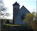
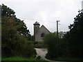
Cross incised stone associated with St Gwnnws Church.
Coflein record:
https://www.coflein.gov.uk/en/site/275652 />
You may be viewing yesterday's version of this page. To see the most up to date information please register for a free account.
")
Do not use the above information on other web sites or publications without permission of the contributor.
Nearby Images from Geograph Britain and Ireland:
©2009(licence)
©2007(licence)
©2023(licence)
©2023(licence)
©2007(licence)
The above images may not be of the site on this page, they are loaded from Geograph.
Please Submit an Image of this site or go out and take one for us!
Click here to see more info for this site
Nearby sites
Key: Red: member's photo, Blue: 3rd party photo, Yellow: other image, Green: no photo - please go there and take one, Grey: site destroyed
Download sites to:
KML (Google Earth)
GPX (GPS waypoints)
CSV (Garmin/Navman)
CSV (Excel)
To unlock full downloads you need to sign up as a Contributory Member. Otherwise downloads are limited to 50 sites.
Turn off the page maps and other distractions
Nearby sites listing. In the following links * = Image available
1.6km E 81° Garreg Lwyd Ancient Village or Settlement (SN70106972)
1.8km ENE 57° Nant Byr Isaf Cairn (SN70037044)
2.5km ESE 105° Pen y Ffrwd* Hillfort (SN709688)
2.7km SSW 202° St Ffraid's Well* Holy Well or Sacred Spring (SN67436705)
3.2km ENE 74° Banc-Y-Geufron* Cairn (SN71637033)
4.4km WNW 300° Gaer Fawr (Lledrod)* Hillfort (SN648718)
4.5km N 1° Coed Ty'n y Cwm* Hillfort (SN687740)
4.7km NE 49° Castle Grogwynion* Hillfort (SN72107249)
5.6km WSW 258° Ty n-yr-eithin* Cairn (SN630685)
5.7km E 80° Carreg Samson, Llethr* Standing Stone (Menhir) (SN74157038)
6.2km ESE 113° Pen-y-Bannau* Hillfort (SN74196689)
7.0km SSW 205° Castell Flemish* Hillfort (SN6538863195)
7.2km ESE 120° Strata Florida Sculptured Stone* Early Christian Sculptured Stone (SN74646577)
7.5km NW 311° Llanilar Hillfort (SN62997454)
7.6km NW 312° Pen-Y-Castell Enclosure Ancient Village or Settlement (SN62997468)
7.9km E 97° Troed Y Rhiw 1 Cairn (SN7636468372)
8.4km ESE 111° Troed Y Rhiw 2 Cairn (SN76336634)
8.4km ESE 121° Ffynnon Llygaid (Drefach)* Holy Well or Sacred Spring (SN7564064940)
8.8km W 275° The Dominicus Stone Early Christian Sculptured Stone (SN597705)
9.3km SE 125° Glasffrwyd Holy Well* Holy Well or Sacred Spring (SN75996399)
9.3km S 177° Castell Tregaron* Hillfort (SN6869760188)
9.4km E 83° Blaen Marchnant Cairn (SN77857040)
9.4km NE 35° Devil's Punch Bowl* Natural Stone / Erratic / Other Natural Feature (SN7417177025)
9.5km S 181° Tregaron Gorsedd Circle* Modern Stone Circle etc (SN6807860037)
9.6km NW 308° Castell Pantmawr Hillfort (SN611756)
View more nearby sites and additional images


 We would like to know more about this location. Please feel free to add a brief description and any relevant information in your own language.
 Wir möchten mehr über diese Stätte erfahren. Bitte zögern Sie nicht, eine kurze Beschreibung und relevante Informationen in Deutsch hinzuzufügen.
 Nous aimerions en savoir encore un peu sur les lieux. S'il vous plaît n'hesitez pas à ajouter une courte description et tous les renseignements pertinents dans votre propre langue.
 Quisieramos informarnos un poco más de las lugares. No dude en añadir una breve descripción y otros datos relevantes en su propio idioma.