


<< Other Photo Pages >> Swansea Gorsedd Circle - Modern Stone Circle etc in Wales in West Glamorgan
Submitted by davidmorgan on Wednesday, 04 February 2015 Page Views: 7544
Modern SitesSite Name: Swansea Gorsedd CircleCountry: Wales
NOTE: This site is 3.171 km away from the location you searched for.
County: West Glamorgan Type: Modern Stone Circle etc
Nearest Town: Swansea
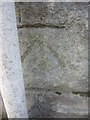
Map Ref: SS6296392660
Latitude: 51.616037N Longitude: 3.980693W
Condition:
| 5 | Perfect |
| 4 | Almost Perfect |
| 3 | Reasonable but with some damage |
| 2 | Ruined but still recognisable as an ancient site |
| 1 | Pretty much destroyed, possibly visible as crop marks |
| 0 | No data. |
| -1 | Completely destroyed |
| 5 | Superb |
| 4 | Good |
| 3 | Ordinary |
| 2 | Not Good |
| 1 | Awful |
| 0 | No data. |
| 5 | Can be driven to, probably with disabled access |
| 4 | Short walk on a footpath |
| 3 | Requiring a bit more of a walk |
| 2 | A long walk |
| 1 | In the middle of nowhere, a nightmare to find |
| 0 | No data. |
| 5 | co-ordinates taken by GPS or official recorded co-ordinates |
| 4 | co-ordinates scaled from a detailed map |
| 3 | co-ordinates scaled from a bad map |
| 2 | co-ordinates of the nearest village |
| 1 | co-ordinates of the nearest town |
| 0 | no data |
Internal Links:
External Links:
")
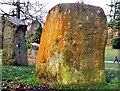
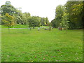
A Gorsedd Stone Circle in Singleton Park, Swansea. First erected in 1925, it was enlarged for the 1964 Eisteddfod.
You may be viewing yesterday's version of this page. To see the most up to date information please register for a free account.
")
")
")
Do not use the above information on other web sites or publications without permission of the contributor.
Nearby Images from Geograph Britain and Ireland:
©2014(licence)
©2017(licence)
©2015(licence)
©2014(licence)
©2014(licence)
The above images may not be of the site on this page, they are loaded from Geograph.
Please Submit an Image of this site or go out and take one for us!
Click here to see more info for this site
Nearby sites
Key: Red: member's photo, Blue: 3rd party photo, Yellow: other image, Green: no photo - please go there and take one, Grey: site destroyed
Download sites to:
KML (Google Earth)
GPX (GPS waypoints)
CSV (Garmin/Navman)
CSV (Excel)
To unlock full downloads you need to sign up as a Contributory Member. Otherwise downloads are limited to 50 sites.
Turn off the page maps and other distractions
Nearby sites listing. In the following links * = Image available
2.2km NNW 347° Cockett Standing Stone Standing Stone (Menhir) (SS6253194791)
5.2km S 184° Mumbles Hill Cave Cave or Rock Shelter (SS625875)
5.6km SSW 200° Rother's Tor Cave Cave or Rock Shelter (SS609874)
5.7km S 184° Mumbles Erratic* Natural Stone / Erratic / Other Natural Feature (SS6241986997)
5.8km SW 221° St Peters's Well* Holy Well or Sacred Spring (SS59048837)
5.9km NNW 334° Carn Goch (West Glamorgan)* Cairn (SS605980)
6.1km NNE 28° Ffynnon Deml* Holy Well or Sacred Spring (SS65969798)
6.1km WSW 252° Bishopston Burch Cairn (SS571909)
6.2km WSW 237° Kittle Hill Cave or Rock Shelter (SS577894)
6.2km SW 219° Caswell Bay Cave Cave or Rock Shelter (SS589879)
6.6km SW 218° Caswell Cliff Fort* Hillfort (SS58808756)
7.2km NW 324° Gorseinon Gorsedd Circle* Modern Stone Circle etc (SS5882998591)
7.8km SW 230° Bishopston Valley* Hillfort (SS569878)
8.3km WSW 246° Trinity Well, Ilston* Holy Well or Sacred Spring (SS55308946)
8.7km SW 224° High Pennard* Hillfort (SS567866)
9.0km SW 228° Bacon Hole* Cave or Rock Shelter (SS561868)
9.2km SW 230° Crow Hole Cave or Rock Shelter (SS558869)
9.3km WSW 247° Gower Heritage centre* Museum (SS543892)
9.5km SW 230° Minchin Hole Cave or Rock Shelter (SS555868)
9.5km WSW 252° Cat Hole Cave* Cave or Rock Shelter (SS53779002)
9.6km WSW 251° Parc le Breos* Chambered Tomb (SS53738984)
9.7km WNW 286° Pen-Y-Gaer (Llanrhidian Lower)* Hillfort (SS53659552)
9.7km WSW 252° Church Hill Earthwork* Misc. Earthwork (SS53628987)
9.8km SW 235° Ravencliffe Cave* Cave or Rock Shelter (SS547873)
10.0km WSW 258° Tooth Cave* Cave or Rock Shelter (SS531909)
View more nearby sites and additional images


 We would like to know more about this location. Please feel free to add a brief description and any relevant information in your own language.
 Wir möchten mehr über diese Stätte erfahren. Bitte zögern Sie nicht, eine kurze Beschreibung und relevante Informationen in Deutsch hinzuzufügen.
 Nous aimerions en savoir encore un peu sur les lieux. S'il vous plaît n'hesitez pas à ajouter une courte description et tous les renseignements pertinents dans votre propre langue.
 Quisieramos informarnos un poco más de las lugares. No dude en añadir una breve descripción y otros datos relevantes en su propio idioma.