


<< Text Pages >> Creigiau'r Gelli Cairn - Cairn in Wales in Gwynedd
Submitted by TAlanJones on Thursday, 15 April 2021 Page Views: 445
Date UncertainSite Name: Creigiau'r Gelli CairnCountry: Wales
NOTE: This site is 0.55 km away from the location you searched for.
County: Gwynedd Type: Cairn
Nearest Town: Bethesda Nearest Village: Capel Curig
Map Ref: SH715584
Latitude: 53.107267N Longitude: 3.921014W
Condition:
| 5 | Perfect |
| 4 | Almost Perfect |
| 3 | Reasonable but with some damage |
| 2 | Ruined but still recognisable as an ancient site |
| 1 | Pretty much destroyed, possibly visible as crop marks |
| 0 | No data. |
| -1 | Completely destroyed |
| 5 | Superb |
| 4 | Good |
| 3 | Ordinary |
| 2 | Not Good |
| 1 | Awful |
| 0 | No data. |
| 5 | Can be driven to, probably with disabled access |
| 4 | Short walk on a footpath |
| 3 | Requiring a bit more of a walk |
| 2 | A long walk |
| 1 | In the middle of nowhere, a nightmare to find |
| 0 | No data. |
| 5 | co-ordinates taken by GPS or official recorded co-ordinates |
| 4 | co-ordinates scaled from a detailed map |
| 3 | co-ordinates scaled from a bad map |
| 2 | co-ordinates of the nearest village |
| 1 | co-ordinates of the nearest town |
| 0 | no data |
Internal Links:
External Links:
Cairn in Gwynedd
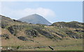
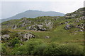
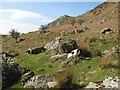
Situated on a natural terrace on the Northern slopes of Creigiau'r Gelli, the cairn is difficult to locate. There are a number of earthen mounds that resemble the shape of cairns but closer examination reveals that the grasses and mosses have overgrown Rocky outcrops.
The cairn is only just recognisable due to the southern side having been totally removed and the remaining stones overgrown. However, I was able to reveal some of the stones underlying. This is a partial cairn shaped like a crescent with a diameter of 5m and a slight rise.
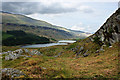
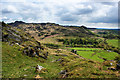
What's left is not much to write home about but the location, overlooking Llynnau Mymbyr and with views across the Snowdon, Glyder and Carneddau mountains is quite something.
You may be viewing yesterday's version of this page. To see the most up to date information please register for a free account.
")
")
")
")
")
Do not use the above information on other web sites or publications without permission of the contributor.
Nearby Images from Geograph Britain and Ireland:
©2010(licence)
©2006(licence)
©2009(licence)
©2010(licence)
©2022(licence)
The above images may not be of the site on this page, they are loaded from Geograph.
Please Submit an Image of this site or go out and take one for us!
Click here to see more info for this site
Nearby sites
Key: Red: member's photo, Blue: 3rd party photo, Yellow: other image, Green: no photo - please go there and take one, Grey: site destroyed
Download sites to:
KML (Google Earth)
GPX (GPS waypoints)
CSV (Garmin/Navman)
CSV (Excel)
To unlock full downloads you need to sign up as a Contributory Member. Otherwise downloads are limited to 50 sites.
Turn off the page maps and other distractions
Nearby sites listing. In the following links * = Image available
919m E 101° Clogwyn Mawr Hut Circle* Ancient Village or Settlement (SH7240058200)
1.7km W 269° Nant y Gors Hut Circle Settlement* Ancient Village or Settlement (SH6982058413)
1.7km W 270° Nant y Gors Cairn and Cist* Cairn (SH6980458433)
1.8km ESE 110° Carnedd Coed Bryn Brethynau* Round Cairn (SH7319057750)
2.4km N 1° Bwlch Cowlyd Cairn* Cairn (SH716608)
2.4km N 351° Cairn West of Bwlch Cowlyd* Cairn (SH712608)
2.5km N 1° Bwlch Cowlyd Hut Circles* Ancient Village or Settlement (SH716609)
2.6km N 3° Maen Trichwmwd Natural Stone / Erratic / Other Natural Feature (SH7169260962)
2.6km NNW 336° Tal y Braich Cairn and Standing Stone Cairn (SH70516079)
2.6km NNW 336° Tal y Braich* Stone Circle (SH705608)
3.2km SE 132° Bryn y Gefeiliau Ancient Trackway* Ancient Trackway (SH7379856215)
3.2km NW 314° Hut Circle Settlement SE of Glan Llugwy Ancient Village or Settlement (SH69226071)
3.5km SE 132° Cefn Glas Round Cairn* Round Cairn (SH7401056010)
3.5km WNW 291° Gwern Gof Isaf* Ancient Village or Settlement (SH68265971)
3.5km SW 235° Dyffryn Mymbyr Round Barrow(s) (SH68565648)
3.5km SW 235° Dyffryn Mymbyr* Standing Stone (Menhir) (SH68565648)
3.6km SE 143° Hut Circle Settlement N of Cefn Glas* Ancient Village or Settlement (SH7362055450)
3.8km SSE 152° Cefn Glas Hut Circle Settlement* Ancient Village or Settlement (SH7318055010)
3.8km SSW 193° Carnedd Moel Siabod* Cairn (SH70535469)
3.9km SSE 147° Cefn Glas Barrow Cemetery* Barrow Cemetery (SH735551)
3.9km N 360° Pen Llithrig Y Wrach* Cairn (SH71606232)
5.2km W 278° Sion a Siân (Adam and Eve) Stones* Natural Stone / Erratic / Other Natural Feature (SH664593)
6.0km WNW 285° Nant Bochllwyd Hut Circle Settlement* Ancient Village or Settlement (SH6577060100)
6.2km SW 229° Nant-y-Llys* Cairn (SH66725450)
6.3km SSE 159° Ffynnon Elan* Holy Well or Sacred Spring (SH736525)
View more nearby sites and additional images


 We would like to know more about this location. Please feel free to add a brief description and any relevant information in your own language.
 Wir möchten mehr über diese Stätte erfahren. Bitte zögern Sie nicht, eine kurze Beschreibung und relevante Informationen in Deutsch hinzuzufügen.
 Nous aimerions en savoir encore un peu sur les lieux. S'il vous plaît n'hesitez pas à ajouter une courte description et tous les renseignements pertinents dans votre propre langue.
 Quisieramos informarnos un poco más de las lugares. No dude en añadir una breve descripción y otros datos relevantes en su propio idioma.