


<< Our Photo Pages >> Bodyst Uchaf ring cairn - Ring Cairn in Wales in Carmarthenshire
Submitted by SandyG on Friday, 03 October 2014 Page Views: 3554
Neolithic and Bronze AgeSite Name: Bodyst Uchaf ring cairnCountry: Wales
NOTE: This site is 2.609 km away from the location you searched for.
County: Carmarthenshire Type: Ring Cairn
Nearest Town: Ammanford Nearest Village: Glanaman
Map Ref: SN66281213
Latitude: 51.791793N Longitude: 3.940286W
Condition:
| 5 | Perfect |
| 4 | Almost Perfect |
| 3 | Reasonable but with some damage |
| 2 | Ruined but still recognisable as an ancient site |
| 1 | Pretty much destroyed, possibly visible as crop marks |
| 0 | No data. |
| -1 | Completely destroyed |
| 5 | Superb |
| 4 | Good |
| 3 | Ordinary |
| 2 | Not Good |
| 1 | Awful |
| 0 | No data. |
| 5 | Can be driven to, probably with disabled access |
| 4 | Short walk on a footpath |
| 3 | Requiring a bit more of a walk |
| 2 | A long walk |
| 1 | In the middle of nowhere, a nightmare to find |
| 0 | No data. |
| 5 | co-ordinates taken by GPS or official recorded co-ordinates |
| 4 | co-ordinates scaled from a detailed map |
| 3 | co-ordinates scaled from a bad map |
| 2 | co-ordinates of the nearest village |
| 1 | co-ordinates of the nearest town |
| 0 | no data |
Internal Links:
External Links:
I have visited· I would like to visit
SandyG has visited here
")
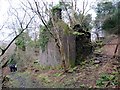
This visual phenomenon is of special interest and may explain why this exact spot was chosen by the cairn builders. The cairn is a Scheduled Ancient Monument.
[Coflein NPRN 304021].
You may be viewing yesterday's version of this page. To see the most up to date information please register for a free account.
")
")
")
Do not use the above information on other web sites or publications without permission of the contributor.
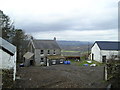
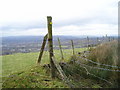
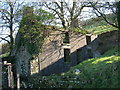
Nearby Images from Geograph Britain and Ireland:
©2010(licence)
©2014(licence)
©2010(licence)
©2008(licence)
©2014(licence)
The above images may not be of the site on this page, they are loaded from Geograph.
Please Submit an Image of this site or go out and take one for us!
Click here to see more info for this site
Nearby sites
Key: Red: member's photo, Blue: 3rd party photo, Yellow: other image, Green: no photo - please go there and take one, Grey: site destroyed
Download sites to:
KML (Google Earth)
GPX (GPS waypoints)
CSV (Garmin/Navman)
CSV (Excel)
To unlock full downloads you need to sign up as a Contributory Member. Otherwise downloads are limited to 50 sites.
Turn off the page maps and other distractions
Nearby sites listing. In the following links * = Image available
1.8km SSE 155° Llech Yr Halen Marker Stone (SN670105)
1.9km SSE 157° Henrhyd Cairns* Cairn (SN66991033)
2.8km ESE 115° Plas-y-coed cairns* Barrow Cemetery (SN68771089)
3.0km SE 128° Bancbryn cairn cemetery* Barrow Cemetery (SN68631021)
3.2km ESE 123° Mynydd y Betws* Stone Row / Alignment (SN6893610326)
3.3km NNW 346° Brownhill Round Barrow* Cairn (SN65551535)
3.4km N 353° Penyrheolddu Standing Stone* Standing Stone (Menhir) (SN65971547)
3.4km N 354° Pen-y-Coed Maen Hir* Standing Stone (Menhir) (SN66011548)
3.4km N 354° Penyrheolddu Ring Cairn* Ring Cairn (SN65991548)
3.4km W 280° Ammanford Gorsedd Stone Circle* Modern Stone Circle etc (SN62931282)
3.4km SE 127° Bancbryn platform cairn* Cairn (SN68950998)
3.7km SE 126° Llety'r-crydd cairn cemetery* Barrow Cemetery (SN69200991)
3.8km N 10° Banc Crucorfod Round Cairn* Round Cairn (SN67021587)
4.2km SSW 203° Pentwyn Mawr Round Cairn (SN64530826)
4.9km SSW 207° Blaenffynhonnau Hut Circle Ancient Village or Settlement (SN63900783)
5.0km NNE 22° Tair Carn Isaf* Cairn (SN68331674)
5.3km NNW 349° Carregdwfn Round Cairn* Cairn (SN65371736)
5.4km NNW 335° Ffynnon Gwyddfan* Holy Well or Sacred Spring (SN6416117112)
5.6km SE 128° Nant-Y-Gaseg modern stone circle* Modern Stone Circle etc (SN7063408515)
5.7km NE 47° Deg Arbedd* Cairn (SN70501591)
5.7km NW 321° Pistyll Mountain Cairn* Cairn (SN62791662)
5.8km SSW 212° Graig Fawr (East) Burnt Mound Misc. Earthwork (SN63080729)
5.8km SSW 212° Graig Fawr Burnt Mound Misc. Earthwork (SN63000728)
6.0km NNE 28° Tair Carn Uchaf* Cairn (SN69211737)
6.1km NNW 328° Pistyll-Ganol Cairn 1* Cairn (SN6315817360)
View more nearby sites and additional images


 We would like to know more about this location. Please feel free to add a brief description and any relevant information in your own language.
 Wir möchten mehr über diese Stätte erfahren. Bitte zögern Sie nicht, eine kurze Beschreibung und relevante Informationen in Deutsch hinzuzufügen.
 Nous aimerions en savoir encore un peu sur les lieux. S'il vous plaît n'hesitez pas à ajouter une courte description et tous les renseignements pertinents dans votre propre langue.
 Quisieramos informarnos un poco más de las lugares. No dude en añadir una breve descripción y otros datos relevantes en su propio idioma.