


<< Our Photo Pages >> Pen Mawr Afon Du Bach - Natural Stone / Erratic / Other Natural Feature in Wales in Gwynedd
Submitted by TAlanJones on Thursday, 24 February 2022 Page Views: 396
Natural PlacesSite Name: Pen Mawr Afon Du BachCountry: Wales
NOTE: This site is 1.928 km away from the location you searched for.
County: Gwynedd Type: Natural Stone / Erratic / Other Natural Feature
Nearest Town: Blaenau Ffestiniog Nearest Village: Llan Ffestiniog
Map Ref: SH71144543
Latitude: 52.990657N Longitude: 3.921197W
Condition:
| 5 | Perfect |
| 4 | Almost Perfect |
| 3 | Reasonable but with some damage |
| 2 | Ruined but still recognisable as an ancient site |
| 1 | Pretty much destroyed, possibly visible as crop marks |
| 0 | No data. |
| -1 | Completely destroyed |
| 5 | Superb |
| 4 | Good |
| 3 | Ordinary |
| 2 | Not Good |
| 1 | Awful |
| 0 | No data. |
| 5 | Can be driven to, probably with disabled access |
| 4 | Short walk on a footpath |
| 3 | Requiring a bit more of a walk |
| 2 | A long walk |
| 1 | In the middle of nowhere, a nightmare to find |
| 0 | No data. |
| 5 | co-ordinates taken by GPS or official recorded co-ordinates |
| 4 | co-ordinates scaled from a detailed map |
| 3 | co-ordinates scaled from a bad map |
| 2 | co-ordinates of the nearest village |
| 1 | co-ordinates of the nearest town |
| 0 | no data |
Internal Links:
External Links:
")
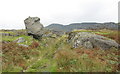
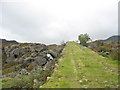
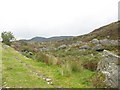
Situated on an elevated position, and seemingly teetering above the old miners track that leads from Manod Rd, Bethania, Blaenau Ffestiniog to the disussed quarry above Llyn Dwr Oer, this huge rock certainly stands out. Approaching from the south west it resembles the profile of a human face glancing towards the Manod Bach mountain. It is also close to Afon Du Bach that cascades down towards Bethania over the waterfall above the old mill.
The stone may be an erratic or a tumble from the quarry above? However, it appears quite frequently on local social media sites and I believe it deserves a marker.
You may be viewing yesterday's version of this page. To see the most up to date information please register for a free account.
")
Do not use the above information on other web sites or publications without permission of the contributor.
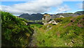
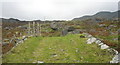
Nearby Images from Geograph Britain and Ireland:
©2023(licence)
©2007(licence)
©2007(licence)
©2007(licence)
©2007(licence)
The above images may not be of the site on this page, they are loaded from Geograph.
Please Submit an Image of this site or go out and take one for us!
Click here to see more info for this site
Nearby sites
Key: Red: member's photo, Blue: 3rd party photo, Yellow: other image, Green: no photo - please go there and take one, Grey: site destroyed
Download sites to:
KML (Google Earth)
GPX (GPS waypoints)
CSV (Garmin/Navman)
CSV (Excel)
To unlock full downloads you need to sign up as a Contributory Member. Otherwise downloads are limited to 50 sites.
Turn off the page maps and other distractions
Nearby sites listing. In the following links * = Image available
965m WSW 255° Cwm Bowydd Farm Hut Circle* Ancient Village or Settlement (SH702452)
1.4km WSW 239° Y Garth Settlement* Ancient Village or Settlement (SH69954475)
1.5km ESE 120° Manod Mawr Shelter Modern Stone Circle etc (SH7239544666)
1.6km S 169° Settlement South of Manod Bach* Ancient Village or Settlement (SH714438)
1.7km SW 224° Llanerch Y Moch standing stone* Modern Stone Circle etc (SH699442)
1.8km WSW 237° Cistfaen Llys Dorfil* Cist (SH69584447)
1.8km WSW 237° Llys Dorfil* Ancient Village or Settlement (SH69574447)
1.8km WSW 237° Llys Dorfil Hut Circle* Ancient Village or Settlement (SH69564447)
1.9km W 271° Gelli Gonan* Ancient Village or Settlement (SH692455)
1.9km SSW 208° Llwyn y Crair Sphynx* Natural Stone / Erratic / Other Natural Feature (SH70184374)
2.1km SE 126° Cwm Teigl Settlement* Ancient Village or Settlement (SH7278244175)
2.2km SE 132° Cwm Teigl Hut Circle* Ancient Village or Settlement (SH7273543921)
2.2km SSE 161° Cwm Teigl Stones* Stone Row / Alignment (SH718433)
2.3km SW 217° Coed y Cribau Hut Circle* Ancient Village or Settlement (SH69744365)
2.5km SW 214° Cymerau Uchaf* Ancient Village or Settlement (SH697434)
2.7km SE 132° Afon Gamallt Hut Circle west* Ancient Village or Settlement (SH7313543535)
2.8km SE 139° Sarn Helen Roman Military Road at Cwm Gamallt* Ancient Trackway (SH729433)
2.8km SE 124° Gamallt Iron Age Settlement* Ancient Village or Settlement (SH734438)
2.8km SE 134° Gamallt Estate Stones* Standing Stones (SH7308743433)
2.8km SE 135° Gamallt Estate hut circle viii* Ancient Village or Settlement (SH7305043393)
2.8km SE 129° Gamallt Hut Circle east* Ancient Village or Settlement (SH7327843594)
2.8km ESE 114° Gamallt hut circles* Ancient Village or Settlement (SH737442)
2.9km NNW 348° Cairn West of Llynnau Barlwyd* Cairn (SH70624831)
2.9km NNW 346° Hut Circle West of Llynnau Barlwyd* Ancient Village or Settlement (SH70504830)
3.0km SE 144° Bryn y Castell* Hillfort (SH7281342969)
View more nearby sites and additional images


 We would like to know more about this location. Please feel free to add a brief description and any relevant information in your own language.
 Wir möchten mehr über diese Stätte erfahren. Bitte zögern Sie nicht, eine kurze Beschreibung und relevante Informationen in Deutsch hinzuzufügen.
 Nous aimerions en savoir encore un peu sur les lieux. S'il vous plaît n'hesitez pas à ajouter une courte description et tous les renseignements pertinents dans votre propre langue.
 Quisieramos informarnos un poco más de las lugares. No dude en añadir una breve descripción y otros datos relevantes en su propio idioma.