


<< Our Photo Pages >> Llangaddock - Standing Stone (Menhir) in Wales in Carmarthenshire
Submitted by coldrum on Wednesday, 21 January 2009 Page Views: 4275
Neolithic and Bronze AgeSite Name: LlangaddockCountry: Wales
NOTE: This site is 0.133 km away from the location you searched for.
County: Carmarthenshire Type: Standing Stone (Menhir)
Nearest Town: Swansea Nearest Village: Llandeilo
Map Ref: SN6943825985
Latitude: 51.917040N Longitude: 3.899762W
Condition:
| 5 | Perfect |
| 4 | Almost Perfect |
| 3 | Reasonable but with some damage |
| 2 | Ruined but still recognisable as an ancient site |
| 1 | Pretty much destroyed, possibly visible as crop marks |
| 0 | No data. |
| -1 | Completely destroyed |
| 5 | Superb |
| 4 | Good |
| 3 | Ordinary |
| 2 | Not Good |
| 1 | Awful |
| 0 | No data. |
| 5 | Can be driven to, probably with disabled access |
| 4 | Short walk on a footpath |
| 3 | Requiring a bit more of a walk |
| 2 | A long walk |
| 1 | In the middle of nowhere, a nightmare to find |
| 0 | No data. |
| 5 | co-ordinates taken by GPS or official recorded co-ordinates |
| 4 | co-ordinates scaled from a detailed map |
| 3 | co-ordinates scaled from a bad map |
| 2 | co-ordinates of the nearest village |
| 1 | co-ordinates of the nearest town |
| 0 | no data |
Be the first person to rate this site - see the 'Contribute!' box in the right hand menu.
Internal Links:
External Links:
")
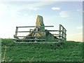
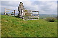
A standing on the east side of some earthworks on the north side of the main road from Llangaddock to Bethlehem.
Greyish coloured stone over 6 feet high with two supporting stones.
Information from The Ancient Stones of Wales, by Chris Barber and John Godfrey Williams, published 1989, ISBN 0951044478.
You may be viewing yesterday's version of this page. To see the most up to date information please register for a free account.
")
")
Do not use the above information on other web sites or publications without permission of the contributor.
coldrum has found this location on Google Street View:
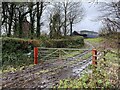
Nearby Images from Geograph Britain and Ireland:
©2008(licence)
©2012(licence)
©2012(licence)
©2012(licence)
©2023(licence)
The above images may not be of the site on this page, they are loaded from Geograph.
Please Submit an Image of this site or go out and take one for us!
Click here to see more info for this site
Nearby sites
Key: Red: member's photo, Blue: 3rd party photo, Yellow: other image, Green: no photo - please go there and take one, Grey: site destroyed
Download sites to:
KML (Google Earth)
GPX (GPS waypoints)
CSV (Garmin/Navman)
CSV (Excel)
To unlock full downloads you need to sign up as a Contributory Member. Otherwise downloads are limited to 50 sites.
Turn off the page maps and other distractions
Nearby sites listing. In the following links * = Image available
1.7km S 189° Carn Goch (Carmarthenshire)* Hillfort (SN69122432)
1.7km S 179° Carn Goch Cairn* Cairn (SN6942924253)
1.9km SSW 206° Gaer Fach, Y Garn Goch* Hillfort (SN6854624271)
2.0km SSW 202° Carreg Canol* Modern Stone Circle etc (SN68632417)
2.2km SW 224° Llwyndu Camp* Hillfort (SN67902447)
2.4km SW 229° Sythfaen Llwyn Du* Standing Stone (Menhir) (SN67562443)
2.8km ENE 72° Tir Mawr Defended Enclosure* Hillfort (SN72102676)
3.0km SSE 169° Trichrug* Cairn (SN69962298)
3.3km N 359° Careg Fawr* Standing Stone (Menhir) (SN69492933)
3.6km WSW 254° Capel Isaf Holy Well Holy Well or Sacred Spring (SN659251)
4.3km SSW 212° Sythfaen (Carmarthenshire)* Standing Stone (Menhir) (SN67052245)
4.8km ENE 63° Mandinam Hill Fort and Earth Works* Hillfort (SN73822808)
5.4km SE 126° Coitan Arthur Natural Stone / Erratic / Other Natural Feature (SN738227)
5.5km N 11° Cwmbran Camp* Hillfort (SN70593135)
6.3km N 353° Bryndyfan Standing Stone* Standing Stone (Menhir) (SN6886732240)
6.6km NE 51° Cilgwyn* Standing Stone (Menhir) (SN7470330061)
7.4km SSW 199° Carreg Cennen Cave* Cave or Rock Shelter (SN6683819064)
7.5km WSW 238° St. Teilo's Holy Well* Holy Well or Sacred Spring (SN62962224)
7.6km S 190° Hen Grofft* Round Barrow(s) (SN67931853)
7.7km SSE 162° Carn Pen-y-Clogau* Cairn (SN71701859)
7.8km NE 54° Llwynmeredydd Defended Enclosure* Hillfort (SN75853037)
7.8km SSE 163° Brynaman* Rock Art (SN7146518453)
7.8km SSE 154° Carn Pen Rhiw Ddu* Cairn (SN72751890)
7.9km S 183° Banc Wernwgan Boundary Stone* Marker Stone (SN68851811)
7.9km ESE 114° Pant-y-Turnor standing stone* Standing Stone (Menhir) (SN766226)
View more nearby sites and additional images


 We would like to know more about this location. Please feel free to add a brief description and any relevant information in your own language.
 Wir möchten mehr über diese Stätte erfahren. Bitte zögern Sie nicht, eine kurze Beschreibung und relevante Informationen in Deutsch hinzuzufügen.
 Nous aimerions en savoir encore un peu sur les lieux. S'il vous plaît n'hesitez pas à ajouter une courte description et tous les renseignements pertinents dans votre propre langue.
 Quisieramos informarnos un poco más de las lugares. No dude en añadir una breve descripción y otros datos relevantes en su propio idioma.