


<< Other Photo Pages >> Killin Broch - Broch or Nuraghe in Scotland in Caithness
Submitted by Andy B on Sunday, 18 April 2010 Page Views: 3879
Iron Age and Later PrehistorySite Name: Killin BrochCountry: Scotland
NOTE: This site is 2.76 km away from the location you searched for.
County: Caithness Type: Broch or Nuraghe
Map Ref: NC867076
Latitude: 58.043007N Longitude: 3.920876W
Condition:
| 5 | Perfect |
| 4 | Almost Perfect |
| 3 | Reasonable but with some damage |
| 2 | Ruined but still recognisable as an ancient site |
| 1 | Pretty much destroyed, possibly visible as crop marks |
| 0 | No data. |
| -1 | Completely destroyed |
| 5 | Superb |
| 4 | Good |
| 3 | Ordinary |
| 2 | Not Good |
| 1 | Awful |
| 0 | No data. |
| 5 | Can be driven to, probably with disabled access |
| 4 | Short walk on a footpath |
| 3 | Requiring a bit more of a walk |
| 2 | A long walk |
| 1 | In the middle of nowhere, a nightmare to find |
| 0 | No data. |
| 5 | co-ordinates taken by GPS or official recorded co-ordinates |
| 4 | co-ordinates scaled from a detailed map |
| 3 | co-ordinates scaled from a bad map |
| 2 | co-ordinates of the nearest village |
| 1 | co-ordinates of the nearest town |
| 0 | no data |
Internal Links:
External Links:
I have visited· I would like to visit
Andy B has visited here
")
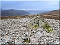
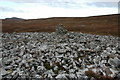
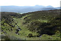
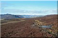
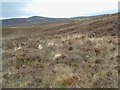
A ruined broch takes its name from the house at the narrows of Loch Brora in the valley below. Very little of the original structure is visible.
Further details are on Canmore
You may be viewing yesterday's version of this page. To see the most up to date information please register for a free account.
Do not use the above information on other web sites or publications without permission of the contributor.
Nearby Images from Geograph Britain and Ireland:
©2014(licence)
©2009(licence)
©2014(licence)
©2016(licence)
©2009(licence)
The above images may not be of the site on this page, they are loaded from Geograph.
Please Submit an Image of this site or go out and take one for us!
Click here to see more info for this site
Nearby sites
Key: Red: member's photo, Blue: 3rd party photo, Yellow: other image, Green: no photo - please go there and take one, Grey: site destroyed
Download sites to:
KML (Google Earth)
GPX (GPS waypoints)
CSV (Garmin/Navman)
CSV (Excel)
To unlock full downloads you need to sign up as a Contributory Member. Otherwise downloads are limited to 50 sites.
Turn off the page maps and other distractions
Nearby sites listing. In the following links * = Image available
2.4km WSW 240° Carrol* Broch or Nuraghe (NC84620646)
4.7km NW 308° Ascoile Henge (NC83091058)
4.9km WNW 295° Kilbraur Broch* Broch or Nuraghe (NC823098)
5.9km SSW 211° Backies Broch* Broch or Nuraghe (NC83450261)
6.2km S 175° Carn Liath (Sutherland)* Broch or Nuraghe (NC8703801376)
6.2km E 84° Cinn Trolla* Broch or Nuraghe (NC92930807)
6.7km SSW 192° Dunrobin Castle* Museum (NC85110103)
6.8km SSW 192° Craigton 1 Class I Pictish Symbol Stone (NC85130093)
8.5km WNW 291° Coich Burn Broch or Nuraghe (NC78801087)
8.6km NE 52° Glen Loth* Standing Stones (NC936127)
8.8km ENE 57° Carn Bran* Broch or Nuraghe (NC94201219)
9.1km NW 307° Caisteal Na Coille* Broch or Nuraghe (NC79571337)
10.5km NE 43° Clach Mhic Mhios* Standing Stone (Menhir) (NC9404515083)
11.2km SW 216° St. Carden's Chapel Class I Pictish Symbol Stone (NH79939870)
12.5km NNE 24° Kilearnan Broch* Broch or Nuraghe (NC92161887)
12.8km NNE 27° Kilearnan Hill* Broch or Nuraghe (NC92931882)
13.0km SW 227° Aberscross* Stone Circle (NH7690399077)
13.4km NE 36° Gailiable Broch or Nuraghe (NC94871823)
13.6km WSW 257° Achnagarron Stones Standing Stones (NC7329804978)
13.8km NNE 33° Balvalaich* Broch or Nuraghe (NC94521898)
14.0km NE 37° Kildonan SW* Multiple Stone Rows / Avenue (NC9550918564)
14.1km W 279° Cnoc An Liath-Bhaid* Stone Circle (NC728102)
14.3km ENE 67° Portgower Broch or Nuraghe (ND00081279)
14.5km SW 232° Thor's Tower Broch or Nuraghe (NH7599)
15.0km SW 235° Carn Liath (Dornoch) Chambered Cairn (NH74119945)
View more nearby sites and additional images


 We would like to know more about this location. Please feel free to add a brief description and any relevant information in your own language.
 Wir möchten mehr über diese Stätte erfahren. Bitte zögern Sie nicht, eine kurze Beschreibung und relevante Informationen in Deutsch hinzuzufügen.
 Nous aimerions en savoir encore un peu sur les lieux. S'il vous plaît n'hesitez pas à ajouter une courte description et tous les renseignements pertinents dans votre propre langue.
 Quisieramos informarnos un poco más de las lugares. No dude en añadir una breve descripción y otros datos relevantes en su propio idioma.