 with our Megalithic Portal iPhone app")

<< Text Pages >> Manod Mawr Shelter - Modern Stone Circle etc in Wales in Gwynedd
Submitted by TAlanJones on Thursday, 23 November 2023 Page Views: 126
Modern SitesSite Name: Manod Mawr ShelterCountry: Wales
NOTE: This site is 2.29 km away from the location you searched for.
County: Gwynedd Type: Modern Stone Circle etc
Nearest Town: Blaenau Ffestiniog Nearest Village: Llan Ffestiniog
Map Ref: SH7239544666
Latitude: 52.984094N Longitude: 3.90221W
Condition:
| 5 | Perfect |
| 4 | Almost Perfect |
| 3 | Reasonable but with some damage |
| 2 | Ruined but still recognisable as an ancient site |
| 1 | Pretty much destroyed, possibly visible as crop marks |
| 0 | No data. |
| -1 | Completely destroyed |
| 5 | Superb |
| 4 | Good |
| 3 | Ordinary |
| 2 | Not Good |
| 1 | Awful |
| 0 | No data. |
| 5 | Can be driven to, probably with disabled access |
| 4 | Short walk on a footpath |
| 3 | Requiring a bit more of a walk |
| 2 | A long walk |
| 1 | In the middle of nowhere, a nightmare to find |
| 0 | No data. |
| 5 | co-ordinates taken by GPS or official recorded co-ordinates |
| 4 | co-ordinates scaled from a detailed map |
| 3 | co-ordinates scaled from a bad map |
| 2 | co-ordinates of the nearest village |
| 1 | co-ordinates of the nearest town |
| 0 | no data |
Internal Links:
External Links:
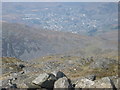
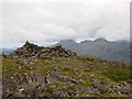
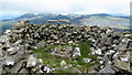
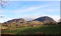
Situated near the summit of Manod Mawr is a circular structure, Coflein NPRN 537245. This is one of several dry stone structures close to the summit, and at 4.5m in diameter by 1m high it is also the largest. Considered a modern construct, it appears to have a concrete base for a flag pole, it commands a prominent position amongst the other structures. Many of which are much older in date.
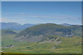
This is a rugged landscape with much evidence of past and recent quarrying that has scarred the surface but, with its many trackways, open adits and abandoned buildings it has also provided a wondrous environment for exploration.
You may be viewing yesterday's version of this page. To see the most up to date information please register for a free account.
")
")
")
")
Do not use the above information on other web sites or publications without permission of the contributor.
Nearby Images from Geograph Britain and Ireland:
©2010(licence)
©2016(licence)
©2023(licence)
©2014(licence)
©2024(licence)
The above images may not be of the site on this page, they are loaded from Geograph.
Please Submit an Image of this site or go out and take one for us!
Click here to see more info for this site
Nearby sites
Key: Red: member's photo, Blue: 3rd party photo, Yellow: other image, Green: no photo - please go there and take one, Grey: site destroyed
Download sites to:
KML (Google Earth)
GPX (GPS waypoints)
CSV (Garmin/Navman)
CSV (Excel)
To unlock full downloads you need to sign up as a Contributory Member. Otherwise downloads are limited to 50 sites.
Turn off the page maps and other distractions
Nearby sites listing. In the following links * = Image available
624m SE 140° Cwm Teigl Settlement* Ancient Village or Settlement (SH7278244175)
818m SSE 154° Cwm Teigl Hut Circle* Ancient Village or Settlement (SH7273543921)
1.3km SW 227° Settlement South of Manod Bach* Ancient Village or Settlement (SH714438)
1.3km SE 129° Gamallt Iron Age Settlement* Ancient Village or Settlement (SH734438)
1.3km SE 145° Afon Gamallt Hut Circle west* Ancient Village or Settlement (SH7313543535)
1.4km ESE 108° Gamallt hut circles* Ancient Village or Settlement (SH737442)
1.4km SE 139° Gamallt Hut Circle east* Ancient Village or Settlement (SH7327843594)
1.4km SSE 149° Gamallt Estate Stones* Standing Stones (SH7308743433)
1.4km SSE 151° Gamallt Estate hut circle viii* Ancient Village or Settlement (SH7305043393)
1.5km SSE 158° Sarn Helen Roman Military Road at Cwm Gamallt* Ancient Trackway (SH729433)
1.5km WNW 300° Pen Mawr Afon Du Bach* Natural Stone / Erratic / Other Natural Feature (SH71144543)
1.5km SSW 202° Cwm Teigl Stones* Stone Row / Alignment (SH718433)
1.5km SE 127° Afon Gamallt Hut Circles and Enclosure* Ancient Village or Settlement (SH7359243730)
1.7km SSE 162° Bryn Y Castell hut circle* Ancient Village or Settlement (SH729430)
1.7km SSE 165° Bryn y Castell* Hillfort (SH7281342969)
2.0km S 175° Cantiorix Lies Here* Early Christian Sculptured Stone (SH725427)
2.2km S 181° Beddau Gwyr Ardudwy* Artificial Mound (SH723425)
2.3km WNW 282° Cwm Bowydd Farm Hut Circle* Ancient Village or Settlement (SH702452)
2.4km SE 144° Llyn Morwynion Hut Circle ii* Ancient Village or Settlement (SH7373942695)
2.4km SE 129° Y Garnedd cairn* Cairn (SH742431)
2.4km WSW 246° Llwyn y Crair Sphynx* Natural Stone / Erratic / Other Natural Feature (SH70184374)
2.4km W 270° Y Garth Settlement* Ancient Village or Settlement (SH69954475)
2.5km SE 146° Llyn Morwynion Hut Circle Settlement* Ancient Village or Settlement (SH7372542594)
2.5km S 181° Sarn Helen Mound* Artificial Mound (SH723422)
2.5km WSW 258° Llanerch Y Moch standing stone* Modern Stone Circle etc (SH699442)
View more nearby sites and additional images


 We would like to know more about this location. Please feel free to add a brief description and any relevant information in your own language.
 Wir möchten mehr über diese Stätte erfahren. Bitte zögern Sie nicht, eine kurze Beschreibung und relevante Informationen in Deutsch hinzuzufügen.
 Nous aimerions en savoir encore un peu sur les lieux. S'il vous plaît n'hesitez pas à ajouter une courte description et tous les renseignements pertinents dans votre propre langue.
 Quisieramos informarnos un poco más de las lugares. No dude en añadir una breve descripción y otros datos relevantes en su propio idioma.