 with our Megalithic Portal iPhone app")


<< Text Pages >> Samson's Stone - Standing Stone (Menhir) in Scotland in Perth and Kinross
Submitted by BigSweetie on Thursday, 25 March 2004 Page Views: 7823
Neolithic and Bronze AgeSite Name: Samson's StoneCountry: Scotland
NOTE: This site is 1.777 km away from the location you searched for.
County: Perth and Kinross Type: Standing Stone (Menhir)
Nearest Town: Crieff Nearest Village: Strowan
Map Ref: NN82512202 Landranger Map Number: 52
Latitude: 56.375830N Longitude: 3.904002W
Condition:
| 5 | Perfect |
| 4 | Almost Perfect |
| 3 | Reasonable but with some damage |
| 2 | Ruined but still recognisable as an ancient site |
| 1 | Pretty much destroyed, possibly visible as crop marks |
| 0 | No data. |
| -1 | Completely destroyed |
| 5 | Superb |
| 4 | Good |
| 3 | Ordinary |
| 2 | Not Good |
| 1 | Awful |
| 0 | No data. |
| 5 | Can be driven to, probably with disabled access |
| 4 | Short walk on a footpath |
| 3 | Requiring a bit more of a walk |
| 2 | A long walk |
| 1 | In the middle of nowhere, a nightmare to find |
| 0 | No data. |
| 5 | co-ordinates taken by GPS or official recorded co-ordinates |
| 4 | co-ordinates scaled from a detailed map |
| 3 | co-ordinates scaled from a bad map |
| 2 | co-ordinates of the nearest village |
| 1 | co-ordinates of the nearest town |
| 0 | no data |
Be the first person to rate this site - see the 'Contribute!' box in the right hand menu.
Internal Links:
External Links:
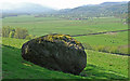
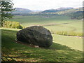
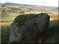
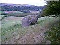
Large rounded boulder on hillside below Creag na Gaoith.
This legendary rock is recorded as Canmore site no. 96866, which records an entry from 1940, saying: "seen from Comrie road on N. Looks merely a huge erratic block on grass field. Probably not megalithic."
The Northern Antiquarian (TNA) features a page for this stone - see their entry for Samson’s Stone, Crieff, Perthshire, which gives directions for finding this stone, together with an image of the 1866 OS map showing the location of the stone, and a brief archaeology & history. TNA adds: "Mistakenly cited by some as a standing stone, the large boulder which rests here on the hillside just below the woodland is a glacial erratic. Highlighted on the 1866 OS-map of the region, I hoped that we might find some rock art on the stone, but cup-and-rings there were none. However, there is a curious ‘footprint’ on top of it, similar to the ones found at Dunnad, at Murlaganmore and other places (see Bord 2004); but I can find no previous reference to this carved footprint."
Note: Have you visited this site? Do you have any photographs or information to add?
You may be viewing yesterday's version of this page. To see the most up to date information please register for a free account.
Do not use the above information on other web sites or publications without permission of the contributor.
Nearby Images from Geograph Britain and Ireland:
©2008(licence)
©2021(licence)
©2008(licence)
©2008(licence)
©2005(licence)
The above images may not be of the site on this page, they are loaded from Geograph.
Please Submit an Image of this site or go out and take one for us!
Click here to see more info for this site
Nearby sites
Key: Red: member's photo, Blue: 3rd party photo, Yellow: other image, Green: no photo - please go there and take one, Grey: site destroyed
Download sites to:
KML (Google Earth)
GPX (GPS waypoints)
CSV (Garmin/Navman)
CSV (Excel)
To unlock full downloads you need to sign up as a Contributory Member. Otherwise downloads are limited to 50 sites.
Turn off the page maps and other distractions
Nearby sites listing. In the following links * = Image available
1.4km SSW 205° Strowan (Crieff)* Cairn (NN819208)
1.7km NW 309° Clathick House Standing Stone (Menhir) (NN81212315)
2.2km SE 129° Rottenreoch Chambered Cairn (NN842206)
2.5km WNW 284° Lawers* Standing Stone (Menhir) (NN80102267)
3.9km SE 129° Concraig* Standing Stone (Menhir) (NN8548419503)
3.9km ESE 119° Dargill* Standing Stone (Menhir) (NN85922004)
4.0km E 96° Crieff Cross Slab* Class III Pictish Cross Slab (NN865215)
4.1km NE 40° Stonefield Circle Stone Circle (NN85252505)
4.2km ESE 105° Duchlage, Crieff Standing Stone (Menhir) (NN86552079)
4.5km ESE 110° Crieff Cursus Cursus (NN86702040)
4.5km SW 236° Auchingarrich Farm Standing Stone (Menhir) (NN78731958)
4.5km W 259° Dalginross* Stone Circle (NN7802521264)
4.9km E 82° Ferntower* Stone Circle (NN874226)
5.0km W 273° Coney Hill (Comrie)* Misc. Earthwork (NN77552238)
5.0km SE 124° Crieff Cursus Cursus (NN86561910)
5.0km SE 126° Crieff Cursus Cursus (NN86531897)
5.2km NW 305° Balmuick* Stone Circle (NN78362513)
5.2km WSW 253° West Cowden* Stone Row / Alignment (NN7744520645)
5.3km SW 217° Craigneich Farm* Standing Stone (Menhir) (NN7922617871)
5.3km WSW 251° Comrie Cursus Cursus (NN77422047)
5.5km WSW 252° Comrie Cursus Cursus (NN77252048)
5.5km W 268° Tom na Chessaig Stone Circle (NN770220)
5.9km S 181° Dalchirla North (Muthill) Standing Stone (Menhir) (NN8227416125)
5.9km ENE 66° Witches' Stone, Monzie* Standing Stone (Menhir) (NN87982431)
5.9km SSW 213° Dunruchan C (Muthill)* Standing Stone (Menhir) (NN7910817137)
View more nearby sites and additional images


 We would like to know more about this location. Please feel free to add a brief description and any relevant information in your own language.
 Wir möchten mehr über diese Stätte erfahren. Bitte zögern Sie nicht, eine kurze Beschreibung und relevante Informationen in Deutsch hinzuzufügen.
 Nous aimerions en savoir encore un peu sur les lieux. S'il vous plaît n'hesitez pas à ajouter une courte description et tous les renseignements pertinents dans votre propre langue.
 Quisieramos informarnos un poco más de las lugares. No dude en añadir una breve descripción y otros datos relevantes en su propio idioma.