


<< Our Photo Pages >> Milton Loch NW - Crannog in Scotland in Dumfries and Galloway
Submitted by markj99 on Tuesday, 27 June 2023 Page Views: 198
Iron Age and Later PrehistorySite Name: Milton Loch NW Alternative Name: Milton Loch 1Country: Scotland
NOTE: This site is 4.854 km away from the location you searched for.
County: Dumfries and Galloway Type: Crannog
Nearest Town: Dumfries Nearest Village: Crocketford
Map Ref: NX83887188
Latitude: 55.027846N Longitude: 3.818111W
Condition:
| 5 | Perfect |
| 4 | Almost Perfect |
| 3 | Reasonable but with some damage |
| 2 | Ruined but still recognisable as an ancient site |
| 1 | Pretty much destroyed, possibly visible as crop marks |
| 0 | No data. |
| -1 | Completely destroyed |
| 5 | Superb |
| 4 | Good |
| 3 | Ordinary |
| 2 | Not Good |
| 1 | Awful |
| 0 | No data. |
| 5 | Can be driven to, probably with disabled access |
| 4 | Short walk on a footpath |
| 3 | Requiring a bit more of a walk |
| 2 | A long walk |
| 1 | In the middle of nowhere, a nightmare to find |
| 0 | No data. |
| 5 | co-ordinates taken by GPS or official recorded co-ordinates |
| 4 | co-ordinates scaled from a detailed map |
| 3 | co-ordinates scaled from a bad map |
| 2 | co-ordinates of the nearest village |
| 1 | co-ordinates of the nearest town |
| 0 | no data |
Internal Links:
External Links:
I have visited· I would like to visit
markj99 visited on 22nd Jun 2023 - their rating: Cond: 2 Amb: 3 Access: 3 Directions to Green Island, Milton Loch: Take the Park of Brandedleys turn off the A75 on the SW edge of Crocketford. Follow the road for c. 0.8 mile to Auchengibbert Farm. Bear left to Kirkgunzeon for c. 0.2 mile to a passing place on the left. Park up and follow a vague path along the margin of the field to the W bank of Milton Loch. My route is viewable on Milton Loch Crannogs.
")
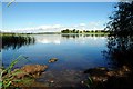
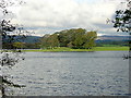
Milton Loch NW Crannog is in the NW corner of Milton Loch c. 1 mile SE of Crocketford in Dumfries and Galloway. According to Canmore ID 65046 the crannog was revealed when the water level of Milton Loch was lowered in 1953. A causeway c. 100 yards long was marked by a double line of wooden posts leading east to a low stone covered island, measuring 35 feet in diameter. The crannog was a circular house, measuring c. 47 feet in overall diameter, constructed in timber. The interior of the house was subdivided radially into compartments. A 6 feet platform supported by wooden posts surrounded the stony island. A small harbour measuring 35 feet was constructed on the SE of the crannog. Further details of archaeological excavations are available in Canmore ID 65046.
The crannog is now populated by mature trees obscuring the surface of the island and the current high water level has submerged the causeway.
You may be viewing yesterday's version of this page. To see the most up to date information please register for a free account.
")
")
Do not use the above information on other web sites or publications without permission of the contributor.
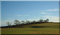
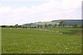
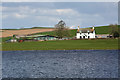
Nearby Images from Geograph Britain and Ireland:
©2012(licence)
©2008(licence)
©2018(licence)
©2007(licence)
©2006(licence)
The above images may not be of the site on this page, they are loaded from Geograph.
Please Submit an Image of this site or go out and take one for us!
Click here to see more info for this site
Nearby sites
Key: Red: member's photo, Blue: 3rd party photo, Yellow: other image, Green: no photo - please go there and take one, Grey: site destroyed
Download sites to:
KML (Google Earth)
GPX (GPS waypoints)
CSV (Garmin/Navman)
CSV (Excel)
To unlock full downloads you need to sign up as a Contributory Member. Otherwise downloads are limited to 50 sites.
Turn off the page maps and other distractions
Nearby sites listing. In the following links * = Image available
242m S 186° Green Island (Milton Loch)* Misc. Earthwork (NX83857164)
394m S 170° Milton Loch Central* Crannog (NX83947149)
788m SSE 148° Milton Loch SE* Crannog (NX84287120)
5.5km SSE 150° St Winning's Well (Kirkgunzeon)* Holy Well or Sacred Spring (NX86526699)
5.8km SSE 151° Kirkgunzeon Stone Circle (NX86576668)
6.0km NNE 30° The Doons* Hillfort (NX86987699)
6.0km ENE 78° Lochrutton Loch* Crannog (NX89837299)
6.8km NNE 29° Angel Well (Barnsoul) Holy Well or Sacred Spring (NX87337770)
8.3km ENE 75° Easthill* Stone Circle (NX91937388)
8.7km SW 222° St Michael's Well (Crossmichael) Holy Well or Sacred Spring (NX7783865566)
8.8km ENE 57° Beacon Hill (Dumfries and Galloway)* Hillfort (NX91397643)
10.1km NE 40° Hall Hill* Hillfort (NX90597949)
10.5km ENE 56° Ladye Well (Terregles) Holy Well or Sacred Spring (NX92767744)
10.6km SSW 192° Slot Well (Buittle) Holy Well or Sacred Spring (NX8134861618)
10.8km SW 215° Ernespie* Stone Circle (NX77476321)
10.9km SSW 197° Rumbling Well (Buittle) Holy Well or Sacred Spring (NX8050061547)
11.2km NE 42° Holywood Cursus Cursus (NX91558004)
11.5km E 87° Picts Knowe* Henge (NX95387213)
11.7km E 87° St Queran's Well* Holy Well or Sacred Spring (NX95597222)
11.7km SW 226° Greenlaw Cairn (NX75186404)
12.3km ENE 73° Troqueer Cursus Cursus (NX95837512)
12.4km N 357° Glenesslin Schoolhouse* Cairn (NX83488433)
12.6km ENE 73° Troqueer Cursus Cursus (NX96137517)
12.9km N 5° White Cairn, Gilmerston Cairn (NX853847)
13.1km NE 54° Twelve Apostles (Dumfries)* Stone Circle (NX9470079400)
View more nearby sites and additional images


 We would like to know more about this location. Please feel free to add a brief description and any relevant information in your own language.
 Wir möchten mehr über diese Stätte erfahren. Bitte zögern Sie nicht, eine kurze Beschreibung und relevante Informationen in Deutsch hinzuzufügen.
 Nous aimerions en savoir encore un peu sur les lieux. S'il vous plaît n'hesitez pas à ajouter une courte description et tous les renseignements pertinents dans votre propre langue.
 Quisieramos informarnos un poco más de las lugares. No dude en añadir una breve descripción y otros datos relevantes en su propio idioma.