<< Our Photo Pages >> Chagford Cross - Ancient Cross in England in Devon
Submitted by Anne T on Monday, 03 June 2019 Page Views: 838
Early Medieval (Dark Age)Site Name: Chagford Cross Alternative Name: St Michael The Archangel Churchyard CrossCountry: England
NOTE: This site is 0.185 km away from the location you searched for.
County: Devon Type: Ancient Cross
Nearest Town: Chagford
Map Ref: SX7020187542
Latitude: 50.673029N Longitude: 3.83828W
Condition:
| 5 | Perfect |
| 4 | Almost Perfect |
| 3 | Reasonable but with some damage |
| 2 | Ruined but still recognisable as an ancient site |
| 1 | Pretty much destroyed, possibly visible as crop marks |
| 0 | No data. |
| -1 | Completely destroyed |
| 5 | Superb |
| 4 | Good |
| 3 | Ordinary |
| 2 | Not Good |
| 1 | Awful |
| 0 | No data. |
| 5 | Can be driven to, probably with disabled access |
| 4 | Short walk on a footpath |
| 3 | Requiring a bit more of a walk |
| 2 | A long walk |
| 1 | In the middle of nowhere, a nightmare to find |
| 0 | No data. |
| 5 | co-ordinates taken by GPS or official recorded co-ordinates |
| 4 | co-ordinates scaled from a detailed map |
| 3 | co-ordinates scaled from a bad map |
| 2 | co-ordinates of the nearest village |
| 1 | co-ordinates of the nearest town |
| 0 | no data |
Internal Links:
External Links:
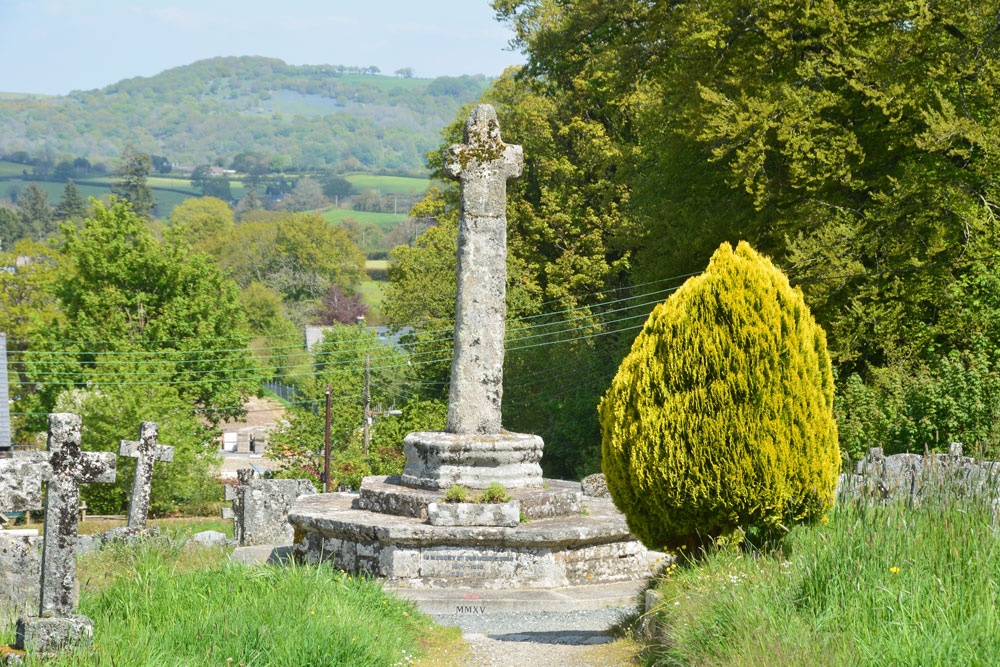
There are two entries for this cross in Pastscape - see Monument No. 445505 and Monument No. 443477.
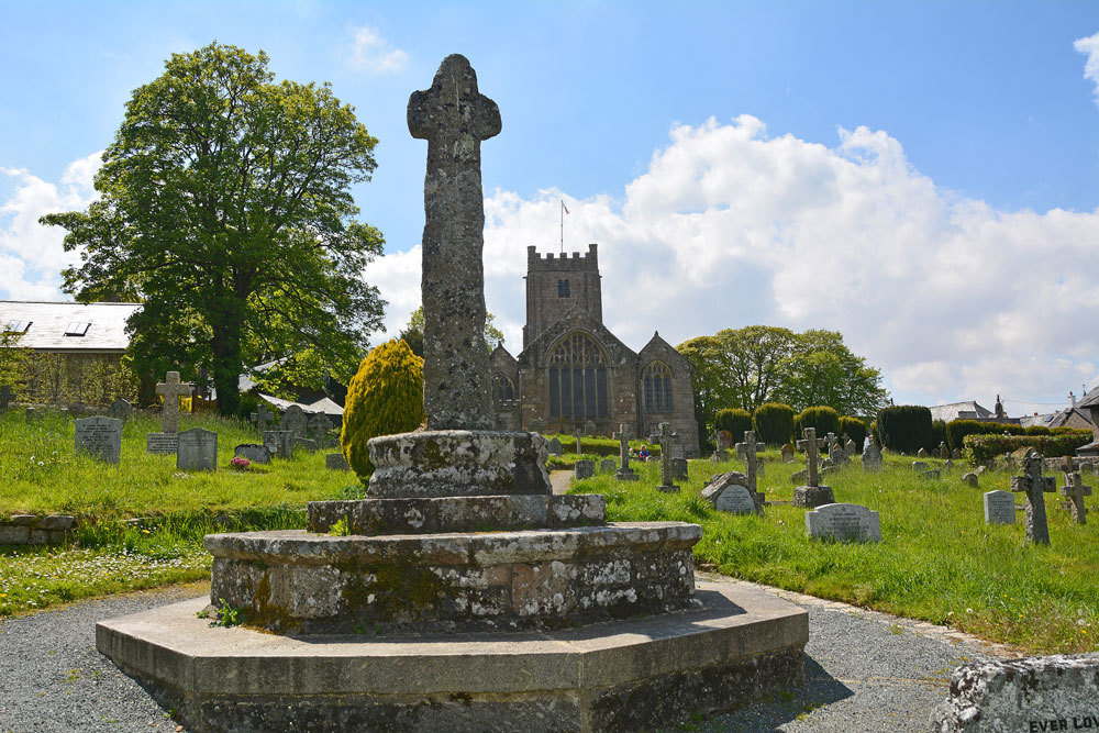
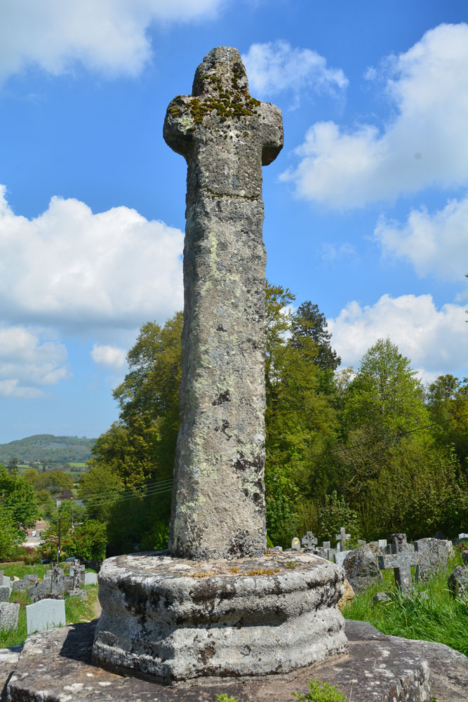
Pastscape 445505 tells us that the modern base/pedestal of the cross was once used as a water trough, now holding a modern cross shaft, to which has been attached the head and arms of an incised cross. Pastscape adds: "Both the socket stone and cross once stood in the market place, but they are quite different in character and do not belong together".
Pastscape 443477 adds a little more detail, saying the head of the former Chagford market cross was taken to nearby Holy Street Farm and later built into a wall near Holystreet Manor to preserve it; it was later attached to a shaft and reused as the Chagford War Memorial.
The cross is also recorded as Historic England List ID 130861 which says the cross was erected as a war memorial in 1928, using fragments of 15th century crosses. It stands 3.8m high, with a tall (modern) shaft and short, stumpy arms, with a cross inscribed on its western face, at the junction of the arms. "The socket stone was from the yard of Southmead House". The market cross used to stand under a tree on the north side of Chagford Market Place.
You may be viewing yesterday's version of this page. To see the most up to date information please register for a free account.



Do not use the above information on other web sites or publications without permission of the contributor.
Click here to see more info for this site
Nearby sites
Key: Red: member's photo, Blue: 3rd party photo, Yellow: other image, Green: no photo - please go there and take one, Grey: site destroyed
Download sites to:
KML (Google Earth)
GPX (GPS waypoints)
CSV (Garmin/Navman)
CSV (Excel)
To unlock full downloads you need to sign up as a Contributory Member. Otherwise downloads are limited to 50 sites.
Turn off the page maps and other distractions
Nearby sites listing. In the following links * = Image available
982m SSE 162° Natterdon Common fort* Hillfort (SX70488660)
1.4km SE 135° Week Down Cross* Ancient Cross (SX7115886534)
1.6km SE 132° Shorter Cross* Ancient Cross (SX7136886437)
1.9km SE 130° Chagford Druid's Well* Holy Well or Sacred Spring (SX71658625)
2.4km ESE 104° Meacombe Cist* Burial Chamber or Dolmen (SX7249486904)
2.5km ESE 108° Meacombe Cist Landscape Natural Stone / Erratic / Other Natural Feature (SX726867)
3.2km N 357° Spinsters' Rock* Burial Chamber or Dolmen (SX70109079)
3.3km N 353° Spinster's Rock Stone Row / Alignment (SX6989090789)
3.3km N 353° Shilstone Common (DRE 1a) Cairn Circle Cairn (SX6990090800)
3.4km SSE 160° Watching Place Waymarker* Marker Stone (SX7130484288)
3.5km SSE 161° Beetor Cross* Ancient Cross (SX7129584187)
3.6km WSW 252° Modern Stone Circle near Kestor Rock* Modern Stone Circle etc (SX66748652)
3.9km WSW 249° Kes Tor Rock Basin* Natural Stone / Erratic / Other Natural Feature (SX66558628)
3.9km WSW 250° Kestor Settlement* Ancient Village or Settlement (SX66538633)
3.9km WSW 258° The Round Pound* Ancient Village or Settlement (SX66398685)
3.9km WSW 250° Kes Tor Cairn* Cairn (SX6653286277)
3.9km SSE 149° Hele Cross* Ancient Cross (SX7213384164)
3.9km ENE 67° Cranbrook Castle* Hillfort (SX7386889010)
4.1km SW 218° Yardworthy* Stone Row / Alignment (SX6760184393)
4.2km S 178° Leeper Cross* Ancient Cross (SX7022083325)
4.3km SW 233° Thornworthy Down Stone Row / Alignment (SX66688505)
4.4km WSW 251° Shovel Down row 1* Stone Row / Alignment (SX660862)
4.4km ENE 64° Charles Cross* Ancient Cross (SX742894)
4.4km S 184° Challacombe Cross Settlement* Ancient Village or Settlement (SX69788313)
4.4km WSW 251° Shovel Down row 2* Multiple Stone Rows / Avenue (SX65958620)
View more nearby sites and additional images




 We would like to know more about this location. Please feel free to add a brief description and any relevant information in your own language.
 Wir möchten mehr über diese Stätte erfahren. Bitte zögern Sie nicht, eine kurze Beschreibung und relevante Informationen in Deutsch hinzuzufügen.
 Nous aimerions en savoir encore un peu sur les lieux. S'il vous plaît n'hesitez pas à ajouter une courte description et tous les renseignements pertinents dans votre propre langue.
 Quisieramos informarnos un poco más de las lugares. No dude en añadir una breve descripción y otros datos relevantes en su propio idioma.